Trail Walking Béhencourt - Le circuit des monts - Photo

Le circuit des monts

© OpenStreetMap contributors
Length
Length
16.4 km
Max alt
Max alt
127 m
Uphill gradient
Uphill gradient
165 m
Km-Effort
Km-Effort  
18.6 km
Min alt
Min alt
45 m
Downhill gradient
Downhill gradient
166 m
Boucle
Boucle
Yes
Creation date :
2014-12-10 00:00:00.0
Updated on :
2014-12-10 00:00:00.0

(0 Reviews)

Walking
Walking
--
Difficulty : Medium

Scan this QR Code to open this trail in the SityTrail application

FREE GPS app for hiking

Logo SityTrail SityTrail

IGN / Geographical institutes

Download SityTrail from the App Store Download SityTrail from Google Play

Logo SityTrail SityTrail World

The world is yours!

Download SityTrail from the App Store Download SityTrail from Google Play Download SityTrail on Huawei AppGallery

About

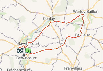
Trail Walking of 16.4 km to be discovered at Hauts-de-France, Somme, Béhencourt. This trail is proposed by vmalterre.

Description

Circuit PR du topoguide FFR de la région picarde.
Particularité:Le menhir de bavelincourt

Elevation profile

Positioning

Country:
France
Region :
Hauts-de-France
Department/Province :
Somme
Municipality :
Béhencourt
Location:
Unknown
Start:(UTM)
460488 ; 5536018 (31U) N.

Trails nearby

Trail Mountain bike Pont-Noyelles - Le passage aux loups - Pont-Noyelles - Photo
Mountain bike
tracegps

Mountain bike

Medium
Pont-Noyelles, Hauts-de-France, Somme, France
13.8 km | 15.7 km-effort
1h 15min
Yes
Trail Walking Pont-Noyelles - Le passage aux loups - Pont-Noyelles - Photo
Walking
tracegps

Walking

Difficult
(1)
Pont-Noyelles, Hauts-de-France, Somme, France
13.8 km | 15.7 km-effort
4h 40min
Yes
Trail Mountain bike Pont-Noyelles - Le passage aux loups - Pont-Noyelles - Photo
Mountain bike
Baltykatt

Mountain bike

Medium
Pont-Noyelles, Hauts-de-France, Somme, France
13.8 km | 15.8 km-effort
1h 15min
Yes
Trail Walking Fréchencourt - frechencourt - Photo
Walking
lefrancm

Walking

Medium
Fréchencourt, Hauts-de-France, Somme, France
20 km | 24 km-effort
4h 5min
Yes
Trail Walking Beaucourt-sur-l'Hallue - Menhir de bavelincourt - Photo
Walking
fitz2014

Walking

Medium
(1)
Beaucourt-sur-l'Hallue, Hauts-de-France, Somme, France
11.3 km | 12.9 km-effort
2h 50min
Yes
Trail Walking Beaucourt-sur-l'Hallue - Menhir Contay - Photo
Walking
Cheyenne80

Walking

Very easy
Beaucourt-sur-l'Hallue, Hauts-de-France, Somme, France
10.6 km | 12.2 km-effort
2h 40min
Yes
Trail Walking Pont-Noyelles - Mont de Corbie - Photo
Walking
Cheyenne80

Walking

Very easy
Pont-Noyelles, Hauts-de-France, Somme, France
13.9 km | 15.9 km-effort
3h 29min
Yes


Close
My subscriptions