![](/images/other/stat-length.png)
![Trail Walking Vernègues - Chateau Bas Aurons Vernègues - Photo](https://media.geolcdn.com/t/1900/400/ext.pjpeg?maxdim=2&url=https%3A%2F%2Fservices.sitytrail.com%2FGeolivesWS%2FDownloadMedia.ashx%3FTrailID%3D130504%26Media%3D20120527113357.jpeg)
Chateau Bas Aurons Vernègues
phidge
User
![Length](/images/other/stat-length.png)
Length
21 km
![Max alt](https://static1.geolcdn.com/siteimages/upload/files/1508320355ic_sort_altitude_max_24dp.png)
Max alt
387 m
![Uphill gradient](https://static1.geolcdn.com/siteimages/upload/files/1508320355ic_sort_den_pos_24dp.png)
Uphill gradient
435 m
![Km-Effort](/images/other/stat-length.png)
Km-Effort
27 km
![Min alt](https://static1.geolcdn.com/siteimages/upload/files/1508320355ic_sort_altitude_min_24dp.png)
Min alt
190 m
![Downhill gradient](https://static1.geolcdn.com/siteimages/upload/files/1508320355ic_sort_den_neg_24dp.png)
Downhill gradient
435 m
![Boucle](https://static1.geolcdn.com/siteimages/upload/files/16400158638029165_repeat_loop_refresh_sync_direction_icon.png)
Boucle
Yes
Creation date :
2019-01-20 16:38:16.49
Updated on :
2019-01-20 16:38:16.536
![Walking](https://static1.geolcdn.com/sitytour/trail-icons/101.png)
6h50
Difficulty : Medium
![Scan this QR Code to open this trail in the SityTrail application](https://capi.geolives.com/qq0zvz2zws4bq2lad0pu/sitytour/trails/130504/qr.png?size=200)
FREE GPS app for hiking
About
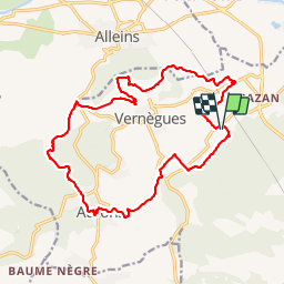
Trail Walking of 21 km to be discovered at Provence-Alpes-Côte d'Azur, Bouches-du-Rhône, Vernègues. This trail is proposed by phidge.
Description
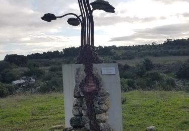
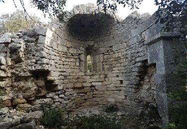
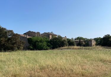
Très agréable, permet de découvrir Aurons et les ruines de Vernègues.
Parcours effectué le 27/05/2012 avec 8 personnes
Positioning
Country:
France
Region :
Provence-Alpes-Côte d'Azur
Department/Province :
Bouches-du-Rhône
Municipality :
Vernègues
Location:
Unknown
Start:(Dec)
Start:(UTM)
676901 ; 4839054 (31T) N.
Comments
Trails nearby
![Walking Walking](https://static1.geolcdn.com/sitytour/trail-icons/101.png)
PF-Alleins - Chapelle Saint-Jean - Rousset - Tour Vieille - Vallon de Valcros...
Walking
Easy
(1)
Alleins,
Provence-Alpes-Côte d'Azur,
Bouches-du-Rhône,
France
![](/images/other/stat-length.png)
7.1 km | 9 km-effort
2h 30min
![](https://static1.geolcdn.com/siteimages/upload/files/16400158638029165_repeat_loop_refresh_sync_direction_icon.png)
Yes
![Trail Walking Charleval - PF-Charleval - Les Costes - Bois des Taillades - Cuou de Peyrou - Photo](https://media.geolcdn.com/t/375/260/67a220c4-295b-4d31-b693-d6441f3ed082.jpg&format=jpg&maxdim=2)
![Walking Walking](https://static1.geolcdn.com/sitytour/trail-icons/101.png)
PF-Charleval - Les Costes - Bois des Taillades - Cuou de Peyrou
Walking
Easy
(1)
Charleval,
Provence-Alpes-Côte d'Azur,
Bouches-du-Rhône,
France
![](/images/other/stat-length.png)
5.2 km | 7.2 km-effort
2h 27min
![](https://static1.geolcdn.com/siteimages/upload/files/16400158638029165_repeat_loop_refresh_sync_direction_icon.png)
Yes
![Trail Walking Vernègues - Château bas-Vernègues-chapelle - Photo](https://media.geolcdn.com/t/375/260/9b82dc84-47a8-451b-adac-f7c55291d235.jpg&format=jpg&maxdim=2)
![Walking Walking](https://static1.geolcdn.com/sitytour/trail-icons/101.png)
Château bas-Vernègues-chapelle
Walking
Easy
(3)
Vernègues,
Provence-Alpes-Côte d'Azur,
Bouches-du-Rhône,
France
![](/images/other/stat-length.png)
9.8 km | 12 km-effort
2h 42min
![](https://static1.geolcdn.com/siteimages/upload/files/16400158638029165_repeat_loop_refresh_sync_direction_icon.png)
Yes
![Trail Walking Alleins - Vernegues, St Jean, Rousset, St Georges, Tour Vieille. - Photo](https://media.geolcdn.com/t/375/260/ext.jpg?maxdim=2&url=https%3A%2F%2Fservices.sitytrail.com%2FGeolivesWS%2FDownloadMedia.ashx%3FTrailID%3D696925%26Media%3Dfix__20170212100152.jpg)
![Walking Walking](https://static1.geolcdn.com/sitytour/trail-icons/101.png)
Vernegues, St Jean, Rousset, St Georges, Tour Vieille.
Walking
Very easy
(1)
Alleins,
Provence-Alpes-Côte d'Azur,
Bouches-du-Rhône,
France
![](/images/other/stat-length.png)
8.1 km | 10.4 km-effort
2h 6min
![](https://static1.geolcdn.com/siteimages/upload/files/16400158638029165_repeat_loop_refresh_sync_direction_icon.png)
Yes
![Trail Other activity Aurons - cabanon douceur - Photo](https://media.geolcdn.com/t/375/260/ext.jpg?maxdim=2&url=https%3A%2F%2Fservices.sitytrail.com%2FGeolivesWS%2FDownloadMedia.ashx%3FTrailID%3D568585%26Media%3Dfix__20160512110504.jpg)
![Other activity Other activity](https://static1.geolcdn.com/sitytour/trail-icons/900.png)
cabanon douceur
Other activity
Very easy
(2)
Aurons,
Provence-Alpes-Côte d'Azur,
Bouches-du-Rhône,
France
![](/images/other/stat-length.png)
6.6 km | 8.2 km-effort
3h 4min
![](https://static1.geolcdn.com/siteimages/upload/files/16400158638029165_repeat_loop_refresh_sync_direction_icon.png)
Yes
![Trail Walking Vernègues - PF-Vernègues - Château Bas-Badasset-Vernègues - Photo](https://media.geolcdn.com/t/375/260/ext.jpg?maxdim=2&url=https%3A%2F%2Fservices.sitytrail.com%2FGeolivesWS%2FDownloadMedia.ashx%3FTrailID%3D524378%26Media%3D20160211154541.jpg)
![Walking Walking](https://static1.geolcdn.com/sitytour/trail-icons/101.png)
PF-Vernègues - Château Bas-Badasset-Vernègues
Walking
Easy
(1)
Vernègues,
Provence-Alpes-Côte d'Azur,
Bouches-du-Rhône,
France
![](/images/other/stat-length.png)
7.8 km | 9.7 km-effort
2h 8min
![](https://static1.geolcdn.com/siteimages/upload/files/16400158638029165_repeat_loop_refresh_sync_direction_icon.png)
Yes
![Trail Mountain bike Aurons - Les Deux Bosquets - Photo](https://media.geolcdn.com/t/375/260/ext.jpg?maxdim=2&url=https%3A%2F%2Fservices.sitytrail.com%2FGeolivesWS%2FDownloadMedia.ashx%3FTrailID%3D108560%26Media%3D1468_2.jpg)
![Mountain bike Mountain bike](https://static1.geolcdn.com/sitytour/trail-icons/202.png)
Les Deux Bosquets
Mountain bike
Difficult
(1)
Aurons,
Provence-Alpes-Côte d'Azur,
Bouches-du-Rhône,
France
![](/images/other/stat-length.png)
7.4 km | 9.3 km-effort
2h 0min
![](https://static1.geolcdn.com/siteimages/upload/files/16400158638029165_repeat_loop_refresh_sync_direction_icon.png)
Yes
![Trail Walking Vernègues - PF-Vernègues - Saint Symphorien - Plateau - Saint Jacques - XA - 11.04.2024 - Photo](https://media.geolcdn.com/t/375/260/8f68e661-d95c-42ca-a729-ff91b0c9ff90.jpg&format=jpg&maxdim=2)
![Walking Walking](https://static1.geolcdn.com/sitytour/trail-icons/101.png)
PF-Vernègues - Saint Symphorien - Plateau - Saint Jacques - XA - 11.04.2024
Walking
Difficult
Vernègues,
Provence-Alpes-Côte d'Azur,
Bouches-du-Rhône,
France
![](/images/other/stat-length.png)
10.2 km | 13.5 km-effort
3h 4min
![](https://static1.geolcdn.com/siteimages/upload/files/16400158638029165_repeat_loop_refresh_sync_direction_icon.png)
Yes
![Walking Walking](https://static1.geolcdn.com/sitytour/trail-icons/101.png)
SityTrail - Les 3 chapelles et la Tour Vieille
Walking
Easy
Alleins,
Provence-Alpes-Côte d'Azur,
Bouches-du-Rhône,
France
![](/images/other/stat-length.png)
6.8 km | 8.2 km-effort
1h 51min
![](https://static1.geolcdn.com/siteimages/upload/files/16400158638029165_repeat_loop_refresh_sync_direction_icon.png)
Yes