![](/images/other/stat-length.png)
![Trail Walking Blot-l'Église - Blot l'Eglise et le Château Rocher - Photo](https://media.geolcdn.com/t/1900/400/ext.pjpeg?maxdim=2&url=https%3A%2F%2Fservices.sitytrail.com%2FGeolivesWS%2FDownloadMedia.ashx%3FTrailID%3D129845%26Media%3D13398_4.jpg)
Blot l'Eglise et le Château Rocher
tracegps
User
![Length](/images/other/stat-length.png)
Length
20 km
![Max alt](https://static1.geolcdn.com/siteimages/upload/files/1508320355ic_sort_altitude_max_24dp.png)
Max alt
633 m
![Uphill gradient](https://static1.geolcdn.com/siteimages/upload/files/1508320355ic_sort_den_pos_24dp.png)
Uphill gradient
629 m
![Km-Effort](/images/other/stat-length.png)
Km-Effort
28 km
![Min alt](https://static1.geolcdn.com/siteimages/upload/files/1508320355ic_sort_altitude_min_24dp.png)
Min alt
362 m
![Downhill gradient](https://static1.geolcdn.com/siteimages/upload/files/1508320355ic_sort_den_neg_24dp.png)
Downhill gradient
627 m
![Boucle](https://static1.geolcdn.com/siteimages/upload/files/16400158638029165_repeat_loop_refresh_sync_direction_icon.png)
Boucle
Yes
Creation date :
2014-12-10 00:00:00.0
Updated on :
2014-12-10 00:00:00.0
![Walking](https://static1.geolcdn.com/sitytour/trail-icons/101.png)
5h30
Difficulty : Difficult
![Scan this QR Code to open this trail in the SityTrail application](https://capi.geolives.com/qq0zvz2zws4bq2lad0pu/sitytour/trails/129845/qr.png?size=200)
FREE GPS app for hiking
About
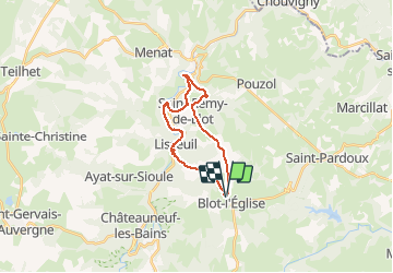
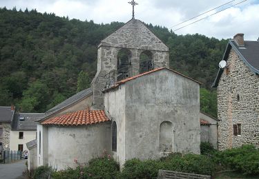
Trail Walking of 20 km to be discovered at Auvergne-Rhône-Alpes, Puy-de-Dôme, Blot-l'Église. This trail is proposed by tracegps.
Description
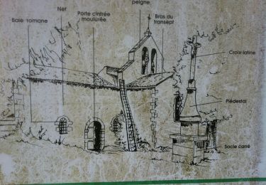
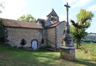
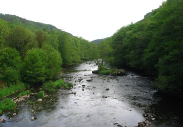
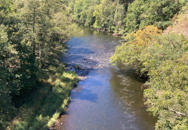
Un bel itinéraire qui longe la Sioule en certains endroits, qui conduit au Château Rocher, ruines en constantes restaurations, avec des paysages vallonnés boisés et des vues de tous cotés. Le parcours peut-être raccourci si besoin un peu au Nord de St-Rémy de Biot.
Positioning
Country:
France
Region :
Auvergne-Rhône-Alpes
Department/Province :
Puy-de-Dôme
Municipality :
Blot-l'Église
Location:
Unknown
Start:(Dec)
Start:(UTM)
496228 ; 5098570 (31T) N.
Comments
Trails nearby
![Trail Walking Blot-l'Église - Blot_Eglise_Pery - Photo](https://media.geolcdn.com/t/375/260/d9de8da0-8f81-48e6-a962-7e78784a81e9.jpg&format=jpg&maxdim=2)
![Walking Walking](https://static1.geolcdn.com/sitytour/trail-icons/101.png)
Blot_Eglise_Pery
Walking
Easy
(2)
Blot-l'Église,
Auvergne-Rhône-Alpes,
Puy-de-Dôme,
France
![](/images/other/stat-length.png)
9.8 km | 12.1 km-effort
3h 0min
![](https://static1.geolcdn.com/siteimages/upload/files/16400158638029165_repeat_loop_refresh_sync_direction_icon.png)
Yes
![Trail Walking Châteauneuf-les-Bains - La chapelle Saint Valentin - Chateauneuf les Bains - Photo](https://media.geolcdn.com/t/375/260/ext.jpg?maxdim=2&url=https%3A%2F%2Fservices.sitytrail.com%2FGeolivesWS%2FDownloadMedia.ashx%3FTrailID%3D107367%26Media%3D12265_4.jpg)
![Walking Walking](https://static1.geolcdn.com/sitytour/trail-icons/101.png)
La chapelle Saint Valentin - Chateauneuf les Bains
Walking
Medium
(2)
Châteauneuf-les-Bains,
Auvergne-Rhône-Alpes,
Puy-de-Dôme,
France
![](/images/other/stat-length.png)
14.4 km | 20 km-effort
3h 49min
![](https://static1.geolcdn.com/siteimages/upload/files/16400158638029165_repeat_loop_refresh_sync_direction_icon.png)
Yes
![Trail On foot Blot-l'Église - Chapelle Saint-Valentin - Photo](https://media.geolcdn.com/t/375/260/636b7308-827b-484c-af88-d10eb681c6f6.jpeg&format=jpg&maxdim=2)
![On foot On foot](https://static1.geolcdn.com/sitytour/trail-icons/100.png)
Chapelle Saint-Valentin
On foot
Easy
Blot-l'Église,
Auvergne-Rhône-Alpes,
Puy-de-Dôme,
France
![](/images/other/stat-length.png)
13.6 km | 19.6 km-effort
4h 26min
![](https://static1.geolcdn.com/siteimages/upload/files/16400158638029165_repeat_loop_refresh_sync_direction_icon.png)
Yes
![Trail On foot Ayat-sur-Sioule - Les Cotes - Photo](https://media.geolcdn.com/t/375/260/1a7ac899-7188-4fdf-bd9b-f25ee51e895d.jpeg&format=jpg&maxdim=2)
![On foot On foot](https://static1.geolcdn.com/sitytour/trail-icons/100.png)
Les Cotes
On foot
Easy
Ayat-sur-Sioule,
Auvergne-Rhône-Alpes,
Puy-de-Dôme,
France
![](/images/other/stat-length.png)
6 km | 8.9 km-effort
2h 1min
![](https://static1.geolcdn.com/siteimages/upload/files/16400158638029165_repeat_loop_refresh_sync_direction_icon.png)
No
![Trail On foot Lisseuil - Lisseuil - Photo](https://media.geolcdn.com/t/375/260/5816c14b-dd3a-4f14-83b4-045502c6d651.jpeg&format=jpg&maxdim=2)
![On foot On foot](https://static1.geolcdn.com/sitytour/trail-icons/100.png)
Lisseuil
On foot
Medium
Lisseuil,
Auvergne-Rhône-Alpes,
Puy-de-Dôme,
France
![](/images/other/stat-length.png)
14.4 km | 20 km-effort
4h 37min
![](https://static1.geolcdn.com/siteimages/upload/files/16400158638029165_repeat_loop_refresh_sync_direction_icon.png)
Yes
![Trail On foot Saint-Rémy-de-Blot - Chateau-Rocher - Photo](https://media.geolcdn.com/t/375/260/b4e40603-7f2c-4069-952e-528bc9ebae62.jpeg&format=jpg&maxdim=2)
![On foot On foot](https://static1.geolcdn.com/sitytour/trail-icons/100.png)
Chateau-Rocher
On foot
Easy
Saint-Rémy-de-Blot,
Auvergne-Rhône-Alpes,
Puy-de-Dôme,
France
![](/images/other/stat-length.png)
4.7 km | 6.9 km-effort
1h 34min
![](https://static1.geolcdn.com/siteimages/upload/files/16400158638029165_repeat_loop_refresh_sync_direction_icon.png)
Yes
![Trail Mountain bike Saint-Angel - St-Angel_Sioule_35 - Photo](https://media.geolcdn.com/t/375/260/ext.jpg?maxdim=2&url=https%3A%2F%2Fstatic1.geolcdn.com%2Fsiteimages%2Fupload%2Ffiles%2F1524743154velo.jpg)
![Mountain bike Mountain bike](https://static1.geolcdn.com/sitytour/trail-icons/202.png)
St-Angel_Sioule_35
Mountain bike
Difficult
(1)
Saint-Angel,
Auvergne-Rhône-Alpes,
Puy-de-Dôme,
France
![](/images/other/stat-length.png)
35 km | 49 km-effort
3h 23min
![](https://static1.geolcdn.com/siteimages/upload/files/16400158638029165_repeat_loop_refresh_sync_direction_icon.png)
Yes
![Trail Walking Lisseuil - Lisseuil_Chateau_Rocher - Photo](https://media.geolcdn.com/t/375/260/d16a416c-06fd-4b71-8673-2d1f708bade4.jpg&format=jpg&maxdim=2)
![Walking Walking](https://static1.geolcdn.com/sitytour/trail-icons/101.png)
Lisseuil_Chateau_Rocher
Walking
Medium
(2)
Lisseuil,
Auvergne-Rhône-Alpes,
Puy-de-Dôme,
France
![](/images/other/stat-length.png)
9.2 km | 13.4 km-effort
2h 45min
![](https://static1.geolcdn.com/siteimages/upload/files/16400158638029165_repeat_loop_refresh_sync_direction_icon.png)
Yes
![Trail Walking Châteauneuf-les-Bains - Gorges de la sioule - Photo](https://media.geolcdn.com/t/375/260/3e504d16-c296-422e-84ea-74304fd11fa5.jpg&format=jpg&maxdim=2)
![Walking Walking](https://static1.geolcdn.com/sitytour/trail-icons/101.png)
Gorges de la sioule
Walking
Easy
Châteauneuf-les-Bains,
Auvergne-Rhône-Alpes,
Puy-de-Dôme,
France
![](/images/other/stat-length.png)
18.7 km | 27 km-effort
6h 3min
![](https://static1.geolcdn.com/siteimages/upload/files/16400158638029165_repeat_loop_refresh_sync_direction_icon.png)
Yes