![](/images/other/stat-length.png)
![Trail Cycle Decazeville - Le carrefour des contrastes - Decazeville - Photo](https://media.geolcdn.com/t/1900/400/ext.pjpeg?maxdim=2&url=https%3A%2F%2Fservices.sitytrail.com%2FGeolivesWS%2FDownloadMedia.ashx%3FTrailID%3D129802%26Media%3D13351_5.jpg)
Le carrefour des contrastes - Decazeville
tracegps
User
![Length](/images/other/stat-length.png)
![Max alt](https://static1.geolcdn.com/siteimages/upload/files/1508320355ic_sort_altitude_max_24dp.png)
![Uphill gradient](https://static1.geolcdn.com/siteimages/upload/files/1508320355ic_sort_den_pos_24dp.png)
![Km-Effort](/images/other/stat-length.png)
![Min alt](https://static1.geolcdn.com/siteimages/upload/files/1508320355ic_sort_altitude_min_24dp.png)
![Downhill gradient](https://static1.geolcdn.com/siteimages/upload/files/1508320355ic_sort_den_neg_24dp.png)
![Boucle](https://static1.geolcdn.com/siteimages/upload/files/16400158638029165_repeat_loop_refresh_sync_direction_icon.png)
![Cycle](https://static1.geolcdn.com/sitytour/trail-icons/200.png)
5h49
Difficulty : Difficult
![Scan this QR Code to open this trail in the SityTrail application](https://capi.geolives.com/qq0zvz2zws4bq2lad0pu/sitytour/trails/129802/qr.png?size=200)
FREE GPS app for hiking
About
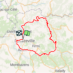
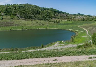
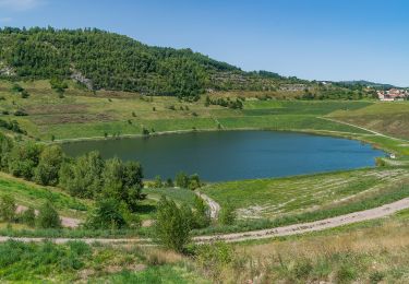
Trail Cycle of 67 km to be discovered at Occitania, Aveyron, Decazeville. This trail is proposed by tracegps.
Description
Circuit proposé par le Comité Départemental de Tourisme de l'Aveyron. Au départ de Decazeville, nous vous invitons à venir découvrir et admirer le charme atypique des paysages du Bassin Decazeville-Aubin; de vastes espaces riches en histoire où se mêle le patrimoine industriel et culturel. Point de convergence des régions Midi-Pyrénées et Auvergne, le bassin est situé à l’ouest du département de l’Aveyron. Carrefour des contrastes, notre territoire est une invitation à la découverte, aux plaisirs de la table, à la convivialité, à l’authenticité. Au fil du Lot, goûtez aux produits du terroir, changez de rythme, plongez dans le bien-être, retrouvez l’histoire des hommes. Un détour que seront appréciés les amoureux de la nature, des espaces offrant sérénité et détente. Vous vous laisserez surprendre par la beauté des sites qui vous plongeront dans une région offrant une diversité d’atouts aussi surprenants les uns que les autres. Vous longerez ensuite « un chemin reconnu », celui menant à Saint-Jacques-de-Compostelle, aujourd’hui très fréquenté par les Pèlerins et les randonneurs. Puis, vous quitterez le bassin pour rejoindre notre fameuse Vallée du Lot, un petit détour vivement recommandé aux promeneurs qui aiment flâner le long des cours d’eau. Arrêtez-vous à Saint-Parthem, charmant petit village, pour découvrir la maison de la rivière. Cet espace scénographique vivant pour petits et grands est dédié à la rivière Lot.
Positioning
Comments
Trails nearby
![Trail Other activity Decazeville - compostelle 2017 mt - Photo](https://media.geolcdn.com/t/375/260/ext.jpg?maxdim=2&url=https%3A%2F%2Fstatic1.geolcdn.com%2Fsiteimages%2Fupload%2Ffiles%2F1545311037marcheuse_200dpi.jpg)
![Other activity Other activity](https://static1.geolcdn.com/sitytour/trail-icons/900.png)
Other activity
![](/images/other/stat-length.png)
![](https://static1.geolcdn.com/siteimages/upload/files/16400158638029165_repeat_loop_refresh_sync_direction_icon.png)
![Trail Walking Livinhac-le-Haut - Livinhac le Haut - Figeac - Chemin de St-Jacques de Compostelle - Photo](https://media.geolcdn.com/t/375/260/ext.jpg?maxdim=2&url=https%3A%2F%2Fservices.sitytrail.com%2FGeolivesWS%2FDownloadMedia.ashx%3FTrailID%3D108748%26Media%3D1843_2.jpg)
![Walking Walking](https://static1.geolcdn.com/sitytour/trail-icons/101.png)
Walking
![](/images/other/stat-length.png)
![](https://static1.geolcdn.com/siteimages/upload/files/16400158638029165_repeat_loop_refresh_sync_direction_icon.png)
![Trail On foot Decazeville - Les découvertes - Photo](https://media.geolcdn.com/t/375/260/dbdb4e7f-cbdd-4117-b74f-a3bed6296852.jpeg&format=jpg&maxdim=2)
![On foot On foot](https://static1.geolcdn.com/sitytour/trail-icons/100.png)
On foot
![](/images/other/stat-length.png)
![](https://static1.geolcdn.com/siteimages/upload/files/16400158638029165_repeat_loop_refresh_sync_direction_icon.png)
![Trail On foot Aubin - Les crêtes de Combes - Photo](https://media.geolcdn.com/t/375/260/482e8e3a-161f-4109-bd88-0e5ccb5b5287.jpeg&format=jpg&maxdim=2)
![On foot On foot](https://static1.geolcdn.com/sitytour/trail-icons/100.png)
On foot
![](/images/other/stat-length.png)
![](https://static1.geolcdn.com/siteimages/upload/files/16400158638029165_repeat_loop_refresh_sync_direction_icon.png)
![Trail On foot Decazeville - Entre plateau et découverte - Photo](https://media.geolcdn.com/t/375/260/482e8e3a-161f-4109-bd88-0e5ccb5b5287.jpeg&format=jpg&maxdim=2)
![On foot On foot](https://static1.geolcdn.com/sitytour/trail-icons/100.png)
On foot
![](/images/other/stat-length.png)
![](https://static1.geolcdn.com/siteimages/upload/files/16400158638029165_repeat_loop_refresh_sync_direction_icon.png)
![Trail On foot Aubin - Entre Deux Vallées - Photo](https://media.geolcdn.com/t/375/260/dbdb4e7f-cbdd-4117-b74f-a3bed6296852.jpeg&format=jpg&maxdim=2)
![On foot On foot](https://static1.geolcdn.com/sitytour/trail-icons/100.png)
On foot
![](/images/other/stat-length.png)
![](https://static1.geolcdn.com/siteimages/upload/files/16400158638029165_repeat_loop_refresh_sync_direction_icon.png)
![Trail On foot Decazeville - Le panoramique - Photo](https://media.geolcdn.com/t/375/260/2922232d-a6ec-4323-81bd-6511998b3c56.jpeg&format=jpg&maxdim=2)
![On foot On foot](https://static1.geolcdn.com/sitytour/trail-icons/100.png)
On foot
![](/images/other/stat-length.png)
![](https://static1.geolcdn.com/siteimages/upload/files/16400158638029165_repeat_loop_refresh_sync_direction_icon.png)
![Trail On foot Aubin - Petit tour de la vaysse - Photo](https://media.geolcdn.com/t/375/260/054d6cf8-8ae7-4015-915e-d1bd93b18074.jpeg&format=jpg&maxdim=2)
![On foot On foot](https://static1.geolcdn.com/sitytour/trail-icons/100.png)
On foot
![](/images/other/stat-length.png)
![](https://static1.geolcdn.com/siteimages/upload/files/16400158638029165_repeat_loop_refresh_sync_direction_icon.png)
![Trail On foot Cransac - Les surprises de la Vaysse - Photo](https://media.geolcdn.com/t/375/260/054d6cf8-8ae7-4015-915e-d1bd93b18074.jpeg&format=jpg&maxdim=2)
![On foot On foot](https://static1.geolcdn.com/sitytour/trail-icons/100.png)
On foot
![](/images/other/stat-length.png)
![](https://static1.geolcdn.com/siteimages/upload/files/16400158638029165_repeat_loop_refresh_sync_direction_icon.png)