![](/images/other/stat-length.png)
![Trail Cycle Foix - Repérage La Mountagnole 2012 - Photo](https://media.geolcdn.com/t/1900/400/ext.pjpeg?maxdim=2&url=https%3A%2F%2Fservices.sitytrail.com%2FGeolivesWS%2FDownloadMedia.ashx%3FTrailID%3D129700%26Media%3D13240_1.jpg)
Repérage La Mountagnole 2012
tracegps
User
![Length](/images/other/stat-length.png)
Length
125 km
![Max alt](https://static1.geolcdn.com/siteimages/upload/files/1508320355ic_sort_altitude_max_24dp.png)
Max alt
957 m
![Uphill gradient](https://static1.geolcdn.com/siteimages/upload/files/1508320355ic_sort_den_pos_24dp.png)
Uphill gradient
2034 m
![Km-Effort](/images/other/stat-length.png)
Km-Effort
152 km
![Min alt](https://static1.geolcdn.com/siteimages/upload/files/1508320355ic_sort_altitude_min_24dp.png)
Min alt
376 m
![Downhill gradient](https://static1.geolcdn.com/siteimages/upload/files/1508320355ic_sort_den_neg_24dp.png)
Downhill gradient
2034 m
![Boucle](https://static1.geolcdn.com/siteimages/upload/files/16400158638029165_repeat_loop_refresh_sync_direction_icon.png)
Boucle
Yes
Creation date :
2014-12-10 00:00:00.0
Updated on :
2014-12-10 00:00:00.0
![Cycle](https://static1.geolcdn.com/sitytour/trail-icons/200.png)
5h30
Difficulty : Difficult
![Scan this QR Code to open this trail in the SityTrail application](https://capi.geolives.com/qq0zvz2zws4bq2lad0pu/sitytour/trails/129700/qr.png?size=200)
FREE GPS app for hiking
About
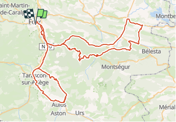
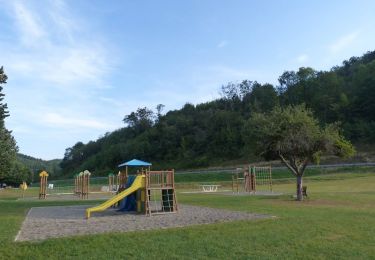
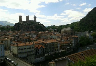
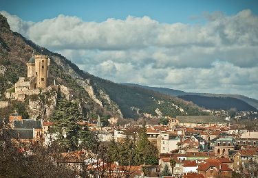
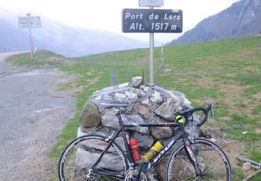
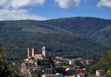
Trail Cycle of 125 km to be discovered at Occitania, Ariège, Foix. This trail is proposed by tracegps.
Description
Ce circuit permet de se faire une idée du circuit de la Mountagnole 2012. Je n'ai pas fait la montée sur le plateau de Beille car il fallait ensuite rentrer ensuite sur Foix et au vue de la météo du jour je ne me suis pas senti physiquement près. Donc à refaire avant l'Ariègeoise 2012.
Positioning
Country:
France
Region :
Occitania
Department/Province :
Ariège
Municipality :
Foix
Location:
Unknown
Start:(Dec)
Start:(UTM)
386488 ; 4757042 (31T) N.
Comments
Trails nearby
![Trail Mountain bike Ganac - Prat Albis - Verniolle - Photo](https://media.geolcdn.com/t/375/260/ext.jpg?maxdim=2&url=https%3A%2F%2Fservices.sitytrail.com%2FGeolivesWS%2FDownloadMedia.ashx%3FTrailID%3D128789%26Media%3D05b2f854-454a-4b38-ac8f-0c42da59f54b.jpg)
![Mountain bike Mountain bike](https://static1.geolcdn.com/sitytour/trail-icons/202.png)
Prat Albis - Verniolle
Mountain bike
Difficult
(1)
Ganac,
Occitania,
Ariège,
France
![](/images/other/stat-length.png)
30 km | 36 km-effort
2h 30min
![](https://static1.geolcdn.com/siteimages/upload/files/16400158638029165_repeat_loop_refresh_sync_direction_icon.png)
No
![Trail Walking Prayols - Cuminge - Photo](https://media.geolcdn.com/t/375/260/ext.jpg?maxdim=2&url=https%3A%2F%2Fstatic1.geolcdn.com%2Fsiteimages%2Fupload%2Ffiles%2F1553511878bg_sport_marche.png)
![Walking Walking](https://static1.geolcdn.com/sitytour/trail-icons/101.png)
![Trail Walking Foix - 01 - FOIX à ROQUEFIXADE - Chemin des Bons-Hommes GR107 GR367 - Photo](https://media.geolcdn.com/t/375/260/ext.jpg?maxdim=2&url=https%3A%2F%2Fservices.sitytrail.com%2FGeolivesWS%2FDownloadMedia.ashx%3FTrailID%3D576319%26Media%3Dfix__20160507165235.jpg)
![Walking Walking](https://static1.geolcdn.com/sitytour/trail-icons/101.png)
01 - FOIX à ROQUEFIXADE - Chemin des Bons-Hommes GR107 GR367
Walking
Difficult
Foix,
Occitania,
Ariège,
France
![](/images/other/stat-length.png)
18.6 km | 30 km-effort
6h 36min
![](https://static1.geolcdn.com/siteimages/upload/files/16400158638029165_repeat_loop_refresh_sync_direction_icon.png)
No
![Trail Walking Saint-Paul-de-Jarrat - De Saint-Paul à Montgailhard - Photo](https://media.geolcdn.com/t/375/260/ext.jpg?maxdim=2&url=https%3A%2F%2Fservices.sitytrail.com%2FGeolivesWS%2FDownloadMedia.ashx%3FTrailID%3D316875%26Media%3D15959_3.jpg)
![Walking Walking](https://static1.geolcdn.com/sitytour/trail-icons/101.png)
De Saint-Paul à Montgailhard
Walking
Medium
Saint-Paul-de-Jarrat,
Occitania,
Ariège,
France
![](/images/other/stat-length.png)
9.9 km | 11.7 km-effort
2h 30min
![](https://static1.geolcdn.com/siteimages/upload/files/16400158638029165_repeat_loop_refresh_sync_direction_icon.png)
Yes
![Trail Walking Foix - pech de foix - Photo](https://media.geolcdn.com/t/375/260/ext.jpg?maxdim=2&url=https%3A%2F%2Fservices.sitytrail.com%2FGeolivesWS%2FDownloadMedia.ashx%3FTrailID%3D302514%26Media%3Dfix__20140517151247.jpg)
![Walking Walking](https://static1.geolcdn.com/sitytour/trail-icons/101.png)
pech de foix
Walking
Very easy
(1)
Foix,
Occitania,
Ariège,
France
![](/images/other/stat-length.png)
7.5 km | 13.6 km-effort
3h 43min
![](https://static1.geolcdn.com/siteimages/upload/files/16400158638029165_repeat_loop_refresh_sync_direction_icon.png)
Yes
![Trail Mountain bike Ganac - prat - prayols 1 - Photo](https://media.geolcdn.com/t/375/260/ext.jpg?maxdim=2&url=https%3A%2F%2Fstatic1.geolcdn.com%2Fsiteimages%2Fupload%2Ffiles%2F1524743154velo.jpg)
![Mountain bike Mountain bike](https://static1.geolcdn.com/sitytour/trail-icons/202.png)
prat - prayols 1
Mountain bike
Medium
(1)
Ganac,
Occitania,
Ariège,
France
![](/images/other/stat-length.png)
7.7 km | 11.1 km-effort
41min
![](https://static1.geolcdn.com/siteimages/upload/files/16400158638029165_repeat_loop_refresh_sync_direction_icon.png)
No
![Trail Cycle Foix - A vélo en Basse Ariège - Foix - Photo](https://media.geolcdn.com/t/375/260/ext.jpg?maxdim=2&url=https%3A%2F%2Fservices.sitytrail.com%2FGeolivesWS%2FDownloadMedia.ashx%3FTrailID%3D215209%26Media%3D15823_6.jpg)
![Cycle Cycle](https://static1.geolcdn.com/sitytour/trail-icons/200.png)
A vélo en Basse Ariège - Foix
Cycle
Medium
Foix,
Occitania,
Ariège,
France
![](/images/other/stat-length.png)
97 km | 111 km-effort
4h 49min
![](https://static1.geolcdn.com/siteimages/upload/files/16400158638029165_repeat_loop_refresh_sync_direction_icon.png)
Yes
![Trail Cycle Foix - Port de Lers - Foix - Photo](https://media.geolcdn.com/t/375/260/ext.jpg?maxdim=2&url=https%3A%2F%2Fservices.sitytrail.com%2FGeolivesWS%2FDownloadMedia.ashx%3FTrailID%3D214964%26Media%3D15533_3.jpg)
![Cycle Cycle](https://static1.geolcdn.com/sitytour/trail-icons/200.png)
Port de Lers - Foix
Cycle
Difficult
Foix,
Occitania,
Ariège,
France
![](/images/other/stat-length.png)
115 km | 152 km-effort
6h 7min
![](https://static1.geolcdn.com/siteimages/upload/files/16400158638029165_repeat_loop_refresh_sync_direction_icon.png)
Yes
![Trail Cycle Foix - De Foix au lac de Montbel - Photo](https://media.geolcdn.com/t/375/260/ext.jpg?maxdim=2&url=https%3A%2F%2Fservices.sitytrail.com%2FGeolivesWS%2FDownloadMedia.ashx%3FTrailID%3D173108%26Media%3D14657_6.jpg)
![Cycle Cycle](https://static1.geolcdn.com/sitytour/trail-icons/200.png)
De Foix au lac de Montbel
Cycle
Difficult
Foix,
Occitania,
Ariège,
France
![](/images/other/stat-length.png)
104 km | 124 km-effort
5h 0min
![](https://static1.geolcdn.com/siteimages/upload/files/16400158638029165_repeat_loop_refresh_sync_direction_icon.png)
Yes