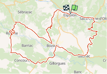
![](/images/other/stat-length.png)
![Trail Cycle Espalion - L'histoire des paysages - Espalion - Photo](https://media.geolcdn.com/t/1900/400/ext.pjpeg?maxdim=2&url=https%3A%2F%2Fservices.sitytrail.com%2FGeolivesWS%2FDownloadMedia.ashx%3FTrailID%3D129678%26Media%3D13210_5.jpg)
L'histoire des paysages - Espalion
tracegps
User
![Length](/images/other/stat-length.png)
![Max alt](https://static1.geolcdn.com/siteimages/upload/files/1508320355ic_sort_altitude_max_24dp.png)
![Uphill gradient](https://static1.geolcdn.com/siteimages/upload/files/1508320355ic_sort_den_pos_24dp.png)
![Km-Effort](/images/other/stat-length.png)
![Min alt](https://static1.geolcdn.com/siteimages/upload/files/1508320355ic_sort_altitude_min_24dp.png)
![Downhill gradient](https://static1.geolcdn.com/siteimages/upload/files/1508320355ic_sort_den_neg_24dp.png)
![Boucle](https://static1.geolcdn.com/siteimages/upload/files/16400158638029165_repeat_loop_refresh_sync_direction_icon.png)
![Cycle](https://static1.geolcdn.com/sitytour/trail-icons/200.png)
4h19
Difficulty : Difficult
![Scan this QR Code to open this trail in the SityTrail application](https://capi.geolives.com/qq0zvz2zws4bq2lad0pu/sitytour/trails/129678/qr.png?size=200)
FREE GPS app for hiking
About
Trail Cycle of 64 km to be discovered at Occitania, Aveyron, Espalion. This trail is proposed by tracegps.
Description
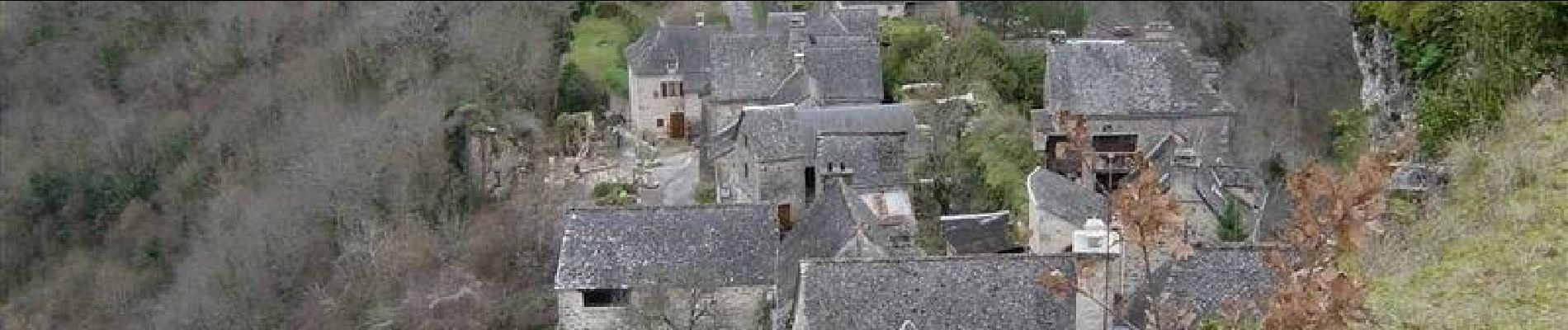
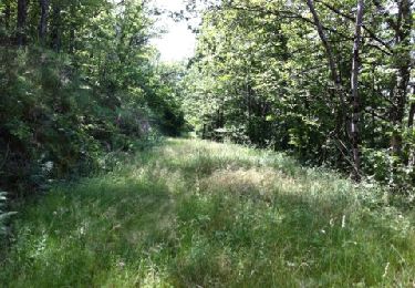
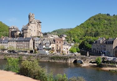
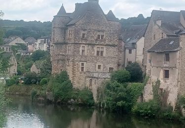
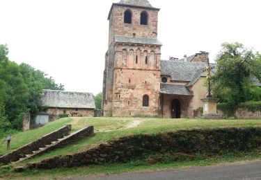
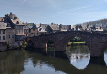
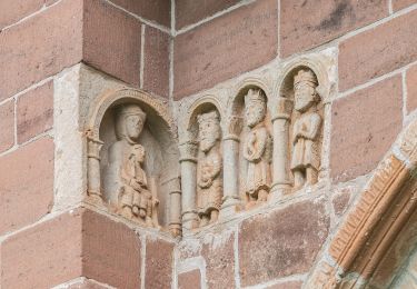
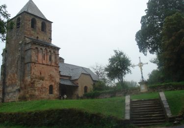
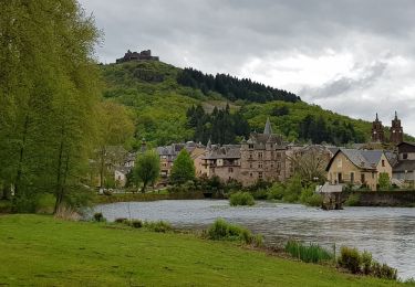
Circuit proposé par le Comité Départemental de Tourisme de l'Aveyron. Entre Monts-d’Aubrac et Causse-Comtal, le Lot (anciennement « olt ») a creusé son lit et a pris ses aises en aval et en amont d’Espalion. En plein cœur de la Vallée du Lot, Espalion est situé sur l’un des grands chemins du pèlerinage de Saint-Jacques-de-Compostelle « Le Puy-en-Velay-sur-Conques » (le GR65), dont ce tronçon et le Pont Vieux ont été classés au Patrimoine mondial de l’Unesco. Vous pourrez plonger dans l’histoire insolite et fascinante de l’homme sous la mer, en visitant le premier musée d’Europe consacré au scaphandre créé pour rendre hommage aux inventions de deux Espalionnais. Un petit détour à l’église de Perse s’impose ; ce joyau d’art roman du XIe siècle est construit en grès rose et situé sur le GR 65. En longeant le Lot en amont, vous n’oublierez pas de faire un petit détour au village fortifié de Flaujac. Ensuite, vous arriverez à Saint-Côme d’Olt, bourg moyenâgeux classé « Plus beaux villages de France », qui présente une église du XVIe siècle surmontée d’un clocher flammé. Une petite route ombragée vous mènera à la Coulée de Lave qui s’étend sur la colline. Cet impressionnant champ de basalte appelé aussi « Clapas de Thubiès » va se perdre dans une forêt de hêtres, de chênes et de châtaigniers. En regagnant le hameau de Roquelaure, où la rivière Lot sera le point de mire de ce périple, ne manquez pas la vue panoramique exceptionnelle depuis l’arrière de la chapelle. Rattrapez le Causse-Comtal et faites le détour pour visiter le petit village de Rodelle situé sur son éperon rocheux. Cette halte est une empreinte de l’un des si nombreux petits joyaux dont recèle notre département. En route vers Bozouls et sa particularité géologique unique en Aveyron ; c’est un canyon de 400 m de diamètre et près de 100 m de profondeur. De ce site géologique est né un espace de découverte, « Terra-Mémoria ».Vous rejoignez Bessuéjouls « la clairière aux buis ». Votre itinéraire vous mène à la remarquable petite église de Saint-Pierre de Bessuéjouls. Sa particularité est une chapelle haute d’un étage où l’on accède par un escalier au fond de la nef. Enfin de retour à Espalion, prenez le temps de flâner dans cette séduisante petite ville.
Positioning
Comments
Trails nearby
![Trail Walking Espalion - Compostelle 08 - Espalion -> Estaing - Photo](https://media.geolcdn.com/t/375/260/ext.jpg?maxdim=2&url=https%3A%2F%2Fservices.sitytrail.com%2FGeolivesWS%2FDownloadMedia.ashx%3FTrailID%3D442134%26Media%3D20120624142259.jpg)
![Walking Walking](https://static1.geolcdn.com/sitytour/trail-icons/101.png)
Walking
![](/images/other/stat-length.png)
![](https://static1.geolcdn.com/siteimages/upload/files/16400158638029165_repeat_loop_refresh_sync_direction_icon.png)
![Trail Walking Espalion - Espalion Massip Avril 2018 - Photo](https://media.geolcdn.com/t/375/260/ext.jpg?maxdim=2&url=https%3A%2F%2Fservices.sitytrail.com%2FGeolivesWS%2FDownloadMedia.ashx%3FTrailID%3D955009%26Media%3Dfix__20180424110415.jpg)
![Walking Walking](https://static1.geolcdn.com/sitytour/trail-icons/101.png)
Walking
![](/images/other/stat-length.png)
![](https://static1.geolcdn.com/siteimages/upload/files/16400158638029165_repeat_loop_refresh_sync_direction_icon.png)
![Trail Walking Espalion - AVEYRON ESPARIAT O - Photo](https://media.geolcdn.com/t/375/260/4565ad9c-3f8a-44cf-88d9-f429e395cd9c.jpg&format=jpg&maxdim=2)
![Walking Walking](https://static1.geolcdn.com/sitytour/trail-icons/101.png)
Walking
![](/images/other/stat-length.png)
![](https://static1.geolcdn.com/siteimages/upload/files/16400158638029165_repeat_loop_refresh_sync_direction_icon.png)
![Trail Walking Saint-Côme-d'Olt - étape st Jacques st come sur d olt-estaing - Photo](https://media.geolcdn.com/t/375/260/474b24f6-c6fb-4dc7-bd61-3496ab5d9373.jpg&format=jpg&maxdim=2)
![Walking Walking](https://static1.geolcdn.com/sitytour/trail-icons/101.png)
Walking
![](/images/other/stat-length.png)
![](https://static1.geolcdn.com/siteimages/upload/files/16400158638029165_repeat_loop_refresh_sync_direction_icon.png)
![Trail Walking Saint-Côme-d'Olt - saint Come d'Olt Estaing - Photo](https://media.geolcdn.com/t/375/260/c7fd43f8-31b2-462b-af01-373edc4bd2c8.jpg&format=jpg&maxdim=2)
![Walking Walking](https://static1.geolcdn.com/sitytour/trail-icons/101.png)
Walking
![](/images/other/stat-length.png)
![](https://static1.geolcdn.com/siteimages/upload/files/16400158638029165_repeat_loop_refresh_sync_direction_icon.png)
![Trail On foot Espalion - La Voie du Rail - Photo](https://media.geolcdn.com/t/375/260/640990e0-ce63-48db-b0cb-2c1e1a59b13d.jpeg&format=jpg&maxdim=2)
![On foot On foot](https://static1.geolcdn.com/sitytour/trail-icons/100.png)
On foot
![](/images/other/stat-length.png)
![](https://static1.geolcdn.com/siteimages/upload/files/16400158638029165_repeat_loop_refresh_sync_direction_icon.png)
![Walking Walking](https://static1.geolcdn.com/sitytour/trail-icons/101.png)
Walking
![](/images/other/stat-length.png)
![](https://static1.geolcdn.com/siteimages/upload/files/16400158638029165_repeat_loop_refresh_sync_direction_icon.png)
![Trail Walking Saint-Côme-d'Olt - saint Côme d'olt- Estaing - Photo](https://media.geolcdn.com/t/375/260/573572db-bc00-4b76-94ac-152ed11426a7.jpg&format=jpg&maxdim=2)
![Walking Walking](https://static1.geolcdn.com/sitytour/trail-icons/101.png)
Walking
![](/images/other/stat-length.png)
![](https://static1.geolcdn.com/siteimages/upload/files/16400158638029165_repeat_loop_refresh_sync_direction_icon.png)
![Trail Walking Saint-Côme-d'Olt - Saint Côme d'Olt vers Estaing - Photo](https://media.geolcdn.com/t/375/260/ext.jpg?maxdim=2&url=https%3A%2F%2Fservices.sitytrail.com%2FGeolivesWS%2FDownloadMedia.ashx%3FTrailID%3D811193%26Media%3D20170816154701.jpg)
![Walking Walking](https://static1.geolcdn.com/sitytour/trail-icons/101.png)
Walking
![](/images/other/stat-length.png)
![](https://static1.geolcdn.com/siteimages/upload/files/16400158638029165_repeat_loop_refresh_sync_direction_icon.png)