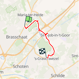
![](/images/other/stat-length.png)
![Trail Walking Brasschaat - Maria Ter Heide - Mikerf - De Kolonie - 's Gravenwezel - Photo](https://media.geolcdn.com/t/1900/400/ext.pjpeg?maxdim=2&url=https%3A%2F%2Fstatic1.geolcdn.com%2Fsiteimages%2Fupload%2Ffiles%2F1553511878bg_sport_marche.png)
Maria Ter Heide - Mikerf - De Kolonie - 's Gravenwezel
LukVL
User
![Length](/images/other/stat-length.png)
Length
12.2 km
![Max alt](https://static1.geolcdn.com/siteimages/upload/files/1508320355ic_sort_altitude_max_24dp.png)
Max alt
32 m
![Uphill gradient](https://static1.geolcdn.com/siteimages/upload/files/1508320355ic_sort_den_pos_24dp.png)
Uphill gradient
79 m
![Km-Effort](/images/other/stat-length.png)
Km-Effort
13.2 km
![Min alt](https://static1.geolcdn.com/siteimages/upload/files/1508320355ic_sort_altitude_min_24dp.png)
Min alt
10 m
![Downhill gradient](https://static1.geolcdn.com/siteimages/upload/files/1508320355ic_sort_den_neg_24dp.png)
Downhill gradient
80 m
![Boucle](https://static1.geolcdn.com/siteimages/upload/files/16400158638029165_repeat_loop_refresh_sync_direction_icon.png)
Boucle
No
Creation date :
2014-12-10 00:00:00.0
Updated on :
2014-12-10 00:00:00.0
![Walking](https://static1.geolcdn.com/sitytour/trail-icons/101.png)
--
Difficulty : Easy
![Scan this QR Code to open this trail in the SityTrail application](https://capi.geolives.com/qq0zvz2zws4bq2lad0pu/sitytour/trails/127798/qr.png?size=200)
FREE GPS app for hiking
About
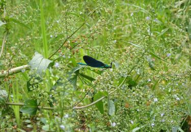
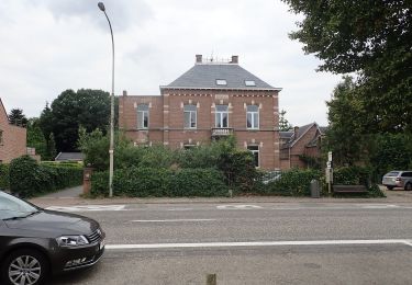
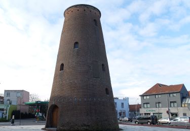
Trail Walking of 12.2 km to be discovered at Flanders, Antwerp, Brasschaat. This trail is proposed by LukVL.
Description
Mooie wandeling vanuit Antwerpen met het openbaar vervoer.
Heen: De Lijn bus 640 tot halte BRASSCHAAT PAUWELSLEI.
Terug: De Lijn 610 halte 'S GRAVENWEZEL EIKENLEI.
Points of interest
Positioning
Country:
Belgium
Region :
Flanders
Department/Province :
Antwerp
Municipality :
Brasschaat
Location:
Brasschaat
Start:(Dec)
Start:(UTM)
605078 ; 5685145 (31U) N.
Comments
Trails nearby
![Trail On foot Brasschaat - Waterpad - Photo](https://media.geolcdn.com/t/375/260/ext.jpg?maxdim=2&url=https%3A%2F%2Fmedia.geolcdn.com%2Ff%2F3c4423df-adee-44e1-b8a7-f10b6f981722.jpeg)
![On foot On foot](https://static1.geolcdn.com/sitytour/trail-icons/100.png)
![Trail On foot Brasschaat - Vriesdonkpad - Photo](https://media.geolcdn.com/t/375/260/ext.jpg?maxdim=2&url=https%3A%2F%2Fmedia.geolcdn.com%2Ff%2F5cf99b83-3fff-480f-bf50-8c22680b5c1a.jpeg)
![On foot On foot](https://static1.geolcdn.com/sitytour/trail-icons/100.png)
Vriesdonkpad
On foot
Easy
Brasschaat,
Flanders,
Antwerp,
Belgium
![](/images/other/stat-length.png)
7.4 km | 7.9 km-effort
1h 48min
![](https://static1.geolcdn.com/siteimages/upload/files/16400158638029165_repeat_loop_refresh_sync_direction_icon.png)
Yes
![Trail On foot Antwerp - Antverpiapad - Photo](https://media.geolcdn.com/t/375/260/ext.jpg?maxdim=2&url=https%3A%2F%2Fmedia.geolcdn.com%2Ff%2F3d97aa58-02af-499e-a512-2ded0c8b1632.jpeg)
![On foot On foot](https://static1.geolcdn.com/sitytour/trail-icons/100.png)
![Trail Walking Schilde - sGravenwezel langs vaart naar Sint-Job - 14 km RT - Photo](https://media.geolcdn.com/t/375/260/ext.jpg?maxdim=2&url=https%3A%2F%2Fstatic1.geolcdn.com%2Fsiteimages%2Fupload%2Ffiles%2F1553511878bg_sport_marche.png)
![Walking Walking](https://static1.geolcdn.com/sitytour/trail-icons/101.png)
sGravenwezel langs vaart naar Sint-Job - 14 km RT
Walking
Very easy
Schilde,
Flanders,
Antwerp,
Belgium
![](/images/other/stat-length.png)
13.8 km | 15 km-effort
Unknown
![](https://static1.geolcdn.com/siteimages/upload/files/16400158638029165_repeat_loop_refresh_sync_direction_icon.png)
Yes
![Trail Walking Brasschaat - Brasschaat Park en Peersbos - 6 km RT - Photo](https://media.geolcdn.com/t/375/260/ext.jpg?maxdim=2&url=https%3A%2F%2Fstatic1.geolcdn.com%2Fsiteimages%2Fupload%2Ffiles%2F1553511878bg_sport_marche.png)
![Walking Walking](https://static1.geolcdn.com/sitytour/trail-icons/101.png)
Brasschaat Park en Peersbos - 6 km RT
Walking
Very easy
(1)
Brasschaat,
Flanders,
Antwerp,
Belgium
![](/images/other/stat-length.png)
6.2 km | 6.9 km-effort
Unknown
![](https://static1.geolcdn.com/siteimages/upload/files/16400158638029165_repeat_loop_refresh_sync_direction_icon.png)
Yes
![Trail Walking Kapellen - klein schietveld - Photo](https://media.geolcdn.com/t/375/260/ext.jpg?maxdim=2&url=https%3A%2F%2Fstatic1.geolcdn.com%2Fsiteimages%2Fupload%2Ffiles%2F1553511878bg_sport_marche.png)
![Walking Walking](https://static1.geolcdn.com/sitytour/trail-icons/101.png)
klein schietveld
Walking
Very easy
(1)
Kapellen,
Flanders,
Antwerp,
Belgium
![](/images/other/stat-length.png)
6.9 km | 7.5 km-effort
1h 56min
![](https://static1.geolcdn.com/siteimages/upload/files/16400158638029165_repeat_loop_refresh_sync_direction_icon.png)
Yes
![Trail On foot Brasschaat - Bethaniepad - Photo](https://media.geolcdn.com/t/375/260/ext.jpg?maxdim=2&url=https%3A%2F%2Fmedia.geolcdn.com%2Ff%2F0b70f99f-4302-4219-9a0b-a894a5a60850.jpeg)
![On foot On foot](https://static1.geolcdn.com/sitytour/trail-icons/100.png)
![Trail On foot Brasschaat - Parkpad - Photo](https://media.geolcdn.com/t/375/260/ext.jpg?maxdim=2&url=https%3A%2F%2Fmedia.geolcdn.com%2Ff%2F453efb65-83fc-4277-8dc1-b58b30da10e7.jpeg)
![On foot On foot](https://static1.geolcdn.com/sitytour/trail-icons/100.png)
![Trail On foot Brasschaat - H. Luytenpad - Photo](https://media.geolcdn.com/t/375/260/ext.jpg?maxdim=2&url=https%3A%2F%2Fmedia.geolcdn.com%2Ff%2Fd075b9ee-920a-44ed-ae43-c512fc81cf73.jpeg)
![On foot On foot](https://static1.geolcdn.com/sitytour/trail-icons/100.png)