Trail Other activity Le Boulou - Nouveau guide - Photo
 beylyc
beylyc

User

© OpenStreetMap contributors
Length
Length
40 km
Max alt
Max alt
704 m
Uphill gradient
Uphill gradient
949 m
Km-Effort
Km-Effort  
51 km
Min alt
Min alt
65 m
Downhill gradient
Downhill gradient
319 m
Boucle
Boucle
No
Creation date :
2014-12-10 00:00:00.0
Updated on :
2014-12-10 00:00:00.0

(0 Reviews)

Other activity
Other activity
--
Difficulty : Unknown

Scan this QR Code to open this trail in the SityTrail application

FREE GPS app for hiking

Logo SityTrail SityTrail

IGN / Geographical institutes

Download SityTrail from the App Store Download SityTrail from Google Play

Logo SityTrail SityTrail World

The world is yours!

Download SityTrail from the App Store Download SityTrail from Google Play Download SityTrail on Huawei AppGallery

About

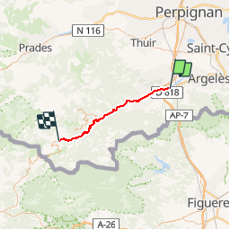
Trail Other activity of 40 km to be discovered at Occitania, Pyrénées-Orientales, Le Boulou. This trail is proposed by beylyc.

Description

Guide points principaux, tour du canigou

Elevation profile

Positioning

Country:
France
Region :
Occitania
Department/Province :
Pyrénées-Orientales
Municipality :
Le Boulou
Location:
Unknown
Start:(UTM)
486578 ; 4708007 (31T) N.

Trails nearby

Trail Walking Le Boulou - rando de la bataille du Boulou - Photo
Walking
GUIDE
stef789

Walking

Very difficult
(1)
Le Boulou, Occitania, Pyrénées-Orientales, France
8.4 km | 10.5 km-effort
3h 27min
Yes
Trail Walking Les Cluses - LES CLUSES 66 - Photo
Walking
jeff66

Walking

Easy
(9)
Les Cluses, Occitania, Pyrénées-Orientales, France
9.4 km | 12.8 km-effort
1h 50min
Yes
Trail Walking Saint-Jean-Pla-de-Corts - 66 ST-JEAN-PLA-DE-CORTS, promenade autour du Tech, jusqu'au BOULOU  - Photo
Walking
jeff66

Walking

Easy
(1)
Saint-Jean-Pla-de-Corts, Occitania, Pyrénées-Orientales, France
7.9 km | 8.8 km-effort
1h 18min
Yes
Trail Walking L'Albère - SAINT-JEAN-D'ALBERE 66 - PUIG  de Sant Christau par le coll de Sant Joan  - Photo
Walking
jeff66

Walking

Difficult
(1)
L'Albère, Occitania, Pyrénées-Orientales, France
10.1 km | 17 km-effort
2h 46min
Yes
Trail Walking Montesquieu-des-Albères - MONTESQUIEU-DES-ALBERES 66 - Les Agouillous - les chemins de l'eau dans les Albères - Photo
Walking
jeff66

Walking

Medium
(1)
Montesquieu-des-Albères, Occitania, Pyrénées-Orientales, France
12.7 km | 13.9 km-effort
2h 16min
Yes
Trail Walking Le Boulou - LES THERMES DU BOULOU - 66 - Albera viva - PUIG de l'Estella - Photo
Walking
jeff66

Walking

Medium
(2)
Le Boulou, Occitania, Pyrénées-Orientales, France
7.3 km | 11.4 km-effort
1h 32min
Yes
Trail Walking Le Boulou - Bataille du Boulou (1793 - 1794) - Photo
Walking
GUIDE
toutankhcarton

Walking

Very easy
Le Boulou, Occitania, Pyrénées-Orientales, France
10.4 km | 13.2 km-effort
1h 57min
Yes
Trail Hybrid bike Le Boulou - Autour du Boulou (66) - Photo
Hybrid bike
GUIDE
toutankhcarton

Hybrid bike

Easy
Le Boulou, Occitania, Pyrénées-Orientales, France
17 km | 19.5 km-effort
1h 54min
No
Trail Walking Le Boulou - Pic Estelle (377m) - Le Boulou - Pyrénées orientales (66) - Photo
Walking
GUIDE
toutankhcarton

Walking

Very easy
Le Boulou, Occitania, Pyrénées-Orientales, France
10.9 km | 15.9 km-effort
2h 19min
Yes


Close
My subscriptions