Trail Walking Soultz-Haut-Rhin - Tour de Rimbach-près-Guebvillers 68500 - Photo

Tour de Rimbach-près-Guebvillers 68500

 davidl03
davidl03

User

© OpenStreetMap contributors
Length
Length
11.7 km
Max alt
Max alt
972 m
Uphill gradient
Uphill gradient
485 m
Km-Effort
Km-Effort  
18.1 km
Min alt
Min alt
537 m
Downhill gradient
Downhill gradient
481 m
Boucle
Boucle
Yes
Creation date :
2014-12-10 00:00:00.0
Updated on :
2014-12-10 00:00:00.0

(0 Reviews)

Walking
Walking
3h30
Difficulty : Easy

Scan this QR Code to open this trail in the SityTrail application

FREE GPS app for hiking

Logo SityTrail SityTrail

IGN / Geographical institutes

Download SityTrail from the App Store Download SityTrail from Google Play

Logo SityTrail SityTrail World

The world is yours!

Download SityTrail from the App Store Download SityTrail from Google Play Download SityTrail on Huawei AppGallery

About

Trail Walking of 11.7 km to be discovered at Grand Est, Haut-Rhin, Soultz-Haut-Rhin. This trail is proposed by davidl03.

Description

Suivre le balisage "Rouge-blanc-rouge"

Tracé plus difficile dans le sens inverse

Elevation profile

Photos

Points of interest

Point of interest Soultz-Haut-Rhin - Glashutte - Photo
davidl03
SOULTZ-HAUT-RHIN 
Point of interest Soultz-Haut-Rhin - Parking pour véhicule - Photo
davidl03
SOULTZ-HAUT-RHIN 
Point of interest Rimbach-près-Guebwiller - Col de Judenhut - Photo
davidl03
RIMBACH-PRÈS-GUEBWILLER 
Point of interest Buhl - Munsteraeckerle - Photo
davidl03
Point of interest Rimbach-près-Guebwiller - Col de Peternic - Photo
davidl03
RIMBACH-PRÈS-GUEBWILLER 

Positioning

Country:
France
Region :
Grand Est
Department/Province :
Haut-Rhin
Municipality :
Soultz-Haut-Rhin
Location:
Unknown
Start:(UTM)
362710 ; 5307497 (32T) N.

Trails nearby

Trail Walking Lautenbachzell - Le Markstein - Photo
Walking
tracegps

Walking

Difficult
(1)
Lautenbachzell, Grand Est, Haut-Rhin, France
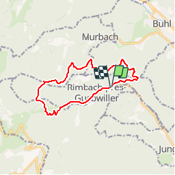
22 km | 35 km-effort
6h 0min
Yes
Trail On foot Goldbach-Altenbach - Firstacker - Willer sur Thur - Photo
On foot
GUIDE+

On foot

Easy
Goldbach-Altenbach, Grand Est, Haut-Rhin, France
7.4 km | 9.6 km-effort
2h 11min
No
Trail Walking Murbach - Rando du 01/08/2024 - Photo
Walking
boubou68

Walking

Very difficult
Murbach, Grand Est, Haut-Rhin, France
18.9 km | 30 km-effort
5h 53min
Yes
Trail Walking Soultz-Haut-Rhin - Rando Marcheurs..04/04_2025 - Photo
Walking
boubou68

Walking

Very difficult
Soultz-Haut-Rhin, Grand Est, Haut-Rhin, France
21 km | 35 km-effort
4h 42min
Yes
Trail Walking Jungholtz - Rando Retrouvailles...01/03/2024.par Jean Marc - Photo
Walking
boubou68

Walking

Very difficult
Jungholtz, Grand Est, Haut-Rhin, France
11.3 km | 19.2 km-effort
1h 35min
Yes
Trail Walking Soultz-Haut-Rhin - Mon tour des Vosges (4 jours) - Photo
Walking
annefrance70

Walking

Very difficult
Soultz-Haut-Rhin, Grand Est, Haut-Rhin, France
71 km | 113 km-effort
25h 38min
Yes
Trail Walking Murbach - La
Walking
boubou68

Walking

Very difficult
Murbach, Grand Est, Haut-Rhin, France
14.7 km | 28 km-effort
4h 3min
Yes
Trail Walking Murbach - Murbach - Photo
Walking
oscar1

Walking

Difficult
Murbach, Grand Est, Haut-Rhin, France
15.4 km | 25 km-effort
4h 25min
Yes
Trail Walking Soultz-Haut-Rhin - Rando avec 0mar et Mouloud..18/02/2023 - Photo
Walking
boubou68

Walking

Very difficult
Soultz-Haut-Rhin, Grand Est, Haut-Rhin, France
12 km | 20 km-effort
3h 9min
Yes


Close
My subscriptions