![](/images/other/stat-length.png)
![Trail Equestrian Grémévillers - gerberoy - Photo](https://media.geolcdn.com/t/1900/400/ext.pjpeg?maxdim=2&url=https%3A%2F%2Fstatic1.geolcdn.com%2Fsiteimages%2Fupload%2Ffiles%2F1524743154cheval.jpg)
gerberoy
hippomobiles
User
![Length](/images/other/stat-length.png)
Length
27 km
![Max alt](https://static1.geolcdn.com/siteimages/upload/files/1508320355ic_sort_altitude_max_24dp.png)
Max alt
191 m
![Uphill gradient](https://static1.geolcdn.com/siteimages/upload/files/1508320355ic_sort_den_pos_24dp.png)
Uphill gradient
363 m
![Km-Effort](/images/other/stat-length.png)
Km-Effort
32 km
![Min alt](https://static1.geolcdn.com/siteimages/upload/files/1508320355ic_sort_altitude_min_24dp.png)
Min alt
103 m
![Downhill gradient](https://static1.geolcdn.com/siteimages/upload/files/1508320355ic_sort_den_neg_24dp.png)
Downhill gradient
360 m
![Boucle](https://static1.geolcdn.com/siteimages/upload/files/16400158638029165_repeat_loop_refresh_sync_direction_icon.png)
Boucle
Yes
Creation date :
2014-12-10 00:00:00.0
Updated on :
2014-12-10 00:00:00.0
![Equestrian](https://static1.geolcdn.com/sitytour/trail-icons/300.png)
--
Difficulty : Difficult
![Scan this QR Code to open this trail in the SityTrail application](https://capi.geolives.com/qq0zvz2zws4bq2lad0pu/sitytour/trails/124353/qr.png?size=200)
FREE GPS app for hiking
About
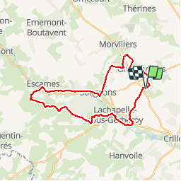
Trail Equestrian of 27 km to be discovered at Hauts-de-France, Oise, Grémévillers. This trail is proposed by hippomobiles.
Description
Randonnée de printemps à l'occasion de la journée nationale de l'attelage de loisirs.
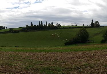
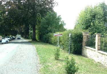
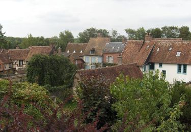
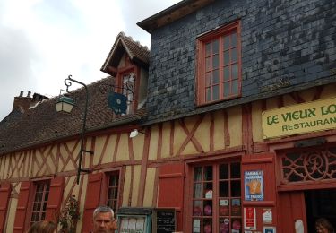
Cette promenade permet de découvrir de très beaux paysages avec en particulier la traversée de Gerberoy. Cette randonnée nécessite des chevaux entrainés compte tenu des dénivelés.
Positioning
Country:
France
Region :
Hauts-de-France
Department/Province :
Oise
Municipality :
Grémévillers
Location:
Unknown
Start:(Dec)
Start:(UTM)
420429 ; 5489482 (31U) N.
Comments
Trails nearby
![Trail Walking Hanvoile - 20200903-Gerberoy - Photo](https://media.geolcdn.com/t/375/260/5a05eb85-8439-4176-8f94-b0fe2d62e8c6.jpg&format=jpg&maxdim=2)
![Walking Walking](https://static1.geolcdn.com/sitytour/trail-icons/101.png)
20200903-Gerberoy
Walking
Medium
Hanvoile,
Hauts-de-France,
Oise,
France
![](/images/other/stat-length.png)
24 km | 29 km-effort
6h 59min
![](https://static1.geolcdn.com/siteimages/upload/files/16400158638029165_repeat_loop_refresh_sync_direction_icon.png)
Yes
![Trail Walking Gerberoy - gerberoy et songeons - Photo](https://media.geolcdn.com/t/375/260/ext.jpg?maxdim=2&url=https%3A%2F%2Fservices.sitytrail.com%2FGeolivesWS%2FDownloadMedia.ashx%3FTrailID%3D798824%26Media%3Dfix__20170730114547.jpg)
![Walking Walking](https://static1.geolcdn.com/sitytour/trail-icons/101.png)
gerberoy et songeons
Walking
Medium
Gerberoy,
Hauts-de-France,
Oise,
France
![](/images/other/stat-length.png)
6.9 km | 9.1 km-effort
1h 46min
![](https://static1.geolcdn.com/siteimages/upload/files/16400158638029165_repeat_loop_refresh_sync_direction_icon.png)
Yes
![Trail Walking Songeons - gerberoy - Photo](https://media.geolcdn.com/t/375/260/ext.jpg?maxdim=2&url=https%3A%2F%2Fstatic1.geolcdn.com%2Fsiteimages%2Fupload%2Ffiles%2F1553511878bg_sport_marche.png)
![Walking Walking](https://static1.geolcdn.com/sitytour/trail-icons/101.png)
gerberoy
Walking
Medium
(2)
Songeons,
Hauts-de-France,
Oise,
France
![](/images/other/stat-length.png)
12.9 km | 16.7 km-effort
Unknown
![](https://static1.geolcdn.com/siteimages/upload/files/16400158638029165_repeat_loop_refresh_sync_direction_icon.png)
Yes
![Trail Walking Songeons - Circuit à la découverte de Gerberoy - Songeons - Photo](https://media.geolcdn.com/t/375/260/ext.jpg?maxdim=2&url=https%3A%2F%2Fservices.sitytrail.com%2FGeolivesWS%2FDownloadMedia.ashx%3FTrailID%3D110353%26Media%3D5805_6.jpg)
![Walking Walking](https://static1.geolcdn.com/sitytour/trail-icons/101.png)
Circuit à la découverte de Gerberoy - Songeons
Walking
Medium
Songeons,
Hauts-de-France,
Oise,
France
![](/images/other/stat-length.png)
9.3 km | 11.9 km-effort
2h 15min
![](https://static1.geolcdn.com/siteimages/upload/files/16400158638029165_repeat_loop_refresh_sync_direction_icon.png)
Yes
![Trail Walking Gerberoy - Sortie Gerberoy 24/05/2018 - Photo](https://media.geolcdn.com/t/375/260/ext.jpg?maxdim=2&url=https%3A%2F%2Fservices.sitytrail.com%2FGeolivesWS%2FDownloadMedia.ashx%3FTrailID%3D979106%26Media%3Dfix__20180524120224.jpg)
![Walking Walking](https://static1.geolcdn.com/sitytour/trail-icons/101.png)
Sortie Gerberoy 24/05/2018
Walking
Easy
Gerberoy,
Hauts-de-France,
Oise,
France
![](/images/other/stat-length.png)
1.2 km | 1.4 km-effort
1h 42min
![](https://static1.geolcdn.com/siteimages/upload/files/16400158638029165_repeat_loop_refresh_sync_direction_icon.png)
Yes
![Trail On foot Gerberoy - gerberoy et les 2 lavoirs - Photo](https://media.geolcdn.com/t/375/260/ext.jpg?maxdim=2&url=https%3A%2F%2Fstatic1.geolcdn.com%2Fsiteimages%2Fupload%2Ffiles%2F1545311037marcheuse_200dpi.jpg)
![On foot On foot](https://static1.geolcdn.com/sitytour/trail-icons/100.png)
gerberoy et les 2 lavoirs
On foot
Easy
Gerberoy,
Hauts-de-France,
Oise,
France
![](/images/other/stat-length.png)
6.8 km | 8.7 km-effort
1h 58min
![](https://static1.geolcdn.com/siteimages/upload/files/16400158638029165_repeat_loop_refresh_sync_direction_icon.png)
Yes
![Trail On foot Gerberoy - gerberoy - Photo](https://media.geolcdn.com/t/375/260/ext.jpg?maxdim=2&url=https%3A%2F%2Fstatic1.geolcdn.com%2Fsiteimages%2Fupload%2Ffiles%2F1545311037marcheuse_200dpi.jpg)
![On foot On foot](https://static1.geolcdn.com/sitytour/trail-icons/100.png)
![Trail Walking Songeons - 20170625 - Songeons - Photo](https://media.geolcdn.com/t/375/260/ext.jpg?maxdim=2&url=https%3A%2F%2Fstatic1.geolcdn.com%2Fsiteimages%2Fupload%2Ffiles%2F1553511878bg_sport_marche.png)
![Walking Walking](https://static1.geolcdn.com/sitytour/trail-icons/101.png)
20170625 - Songeons
Walking
Very difficult
Songeons,
Hauts-de-France,
Oise,
France
![](/images/other/stat-length.png)
16.8 km | 22 km-effort
4h 55min
![](https://static1.geolcdn.com/siteimages/upload/files/16400158638029165_repeat_loop_refresh_sync_direction_icon.png)
Yes
![Trail Walking Gerberoy - Gerberoy vers Songeons et retour - Photo](https://media.geolcdn.com/t/375/260/ext.jpg?maxdim=2&url=https%3A%2F%2Fstatic1.geolcdn.com%2Fsiteimages%2Fupload%2Ffiles%2F1553511878bg_sport_marche.png)
![Walking Walking](https://static1.geolcdn.com/sitytour/trail-icons/101.png)
Gerberoy vers Songeons et retour
Walking
Very easy
Gerberoy,
Hauts-de-France,
Oise,
France
![](/images/other/stat-length.png)
7 km | 8.7 km-effort
1h 50min
![](https://static1.geolcdn.com/siteimages/upload/files/16400158638029165_repeat_loop_refresh_sync_direction_icon.png)
No