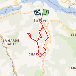
![](/images/other/stat-length.png)
![Trail Walking Ubaye-Serre-Ponçon - Circuit de Clot la Cime - Photo](https://media.geolcdn.com/t/1900/400/ext.pjpeg?maxdim=2&url=https%3A%2F%2Fstatic1.geolcdn.com%2Fsiteimages%2Fupload%2Ffiles%2F1553511878bg_sport_marche.png)
Circuit de Clot la Cime
saintherant
User
![Length](/images/other/stat-length.png)
![Max alt](https://static1.geolcdn.com/siteimages/upload/files/1508320355ic_sort_altitude_max_24dp.png)
![Uphill gradient](https://static1.geolcdn.com/siteimages/upload/files/1508320355ic_sort_den_pos_24dp.png)
![Km-Effort](/images/other/stat-length.png)
![Min alt](https://static1.geolcdn.com/siteimages/upload/files/1508320355ic_sort_altitude_min_24dp.png)
![Downhill gradient](https://static1.geolcdn.com/siteimages/upload/files/1508320355ic_sort_den_neg_24dp.png)
![Boucle](https://static1.geolcdn.com/siteimages/upload/files/16400158638029165_repeat_loop_refresh_sync_direction_icon.png)
![Walking](https://static1.geolcdn.com/sitytour/trail-icons/101.png)
4h30
Difficulty : Difficult
![Scan this QR Code to open this trail in the SityTrail application](https://capi.geolives.com/qq0zvz2zws4bq2lad0pu/sitytour/trails/123765/qr.png?size=200)
FREE GPS app for hiking
About
Trail Walking of 12.6 km to be discovered at Provence-Alpes-Côte d'Azur, Alpes-de-Haute-Provence, Ubaye-Serre-Ponçon. This trail is proposed by saintherant.
Description
Distance : 12.8 kms Dénivelé : 700 m Temps : 4 h 30
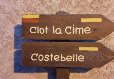
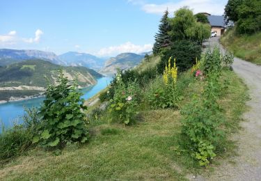
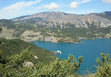
Au départ du village de La Bréole, le circuit de Clot la Cime vous offrira une randonnée réservée au bons marcheurs qui vous mènera jusqu’au point culminant de la commune de La Bréole à 1580 mètres et son magnifique panorama sur le lac de Serre-Ponçon et la vallée de la Durance.
Du parking, rejoindre la Fontaine de La Bréole située en face de l’épicerie à un centaine de mètres. Prendre la ruelle partant entre les maisons en direction de Clot la Cime - Costebelle, traverser la route départementale (CD 900B) et poursuivre sur le chemin qui part en face et vire à gauche. Au point La Touisse (980 m), prendre le sentier qui monte à droite en direction de Clot la Cime. Après 5 à 600 mètres le sentier se transforme en un chemin forestier avec quelques traversées de clairières. Suivre le balisage en étant bien vigilant lors des nombreuses bifurcations avec d’autres chemins ou traines à bois. Il est intéressant de savoir que cette forêt sur les pentes du Clot la Cime appartenait aux nobles locaux et qu’à la révolution elle fut partagée entre les habitants.
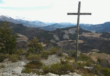
Arrivé au point Clapouse (1380 m) le sentier croise un large chemin prendre en face jusqu’à l’Oratoire de Clot la Cime ou autrefois, une procession était organisée chaque Lundi de Pentecôte.
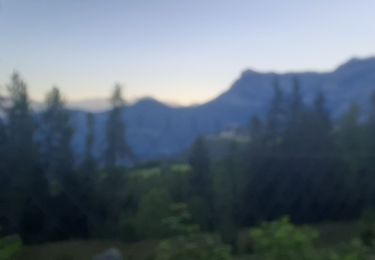
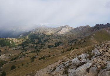
Continuer la montée tout droit jusqu’au sommet, la partie finale suit un sentier assez peu marqué au sol le long de la crête jusqu’au Clot la Cime (1580m) point culminant de La Bréole. Le sommet offre un point de vue magnifique sur la vallée de la Durance et le lac de Serre-Ponçon.
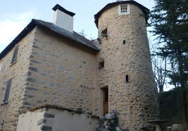
Pour redescendre, passer le petit portillon et descendez dans la clairière jusqu’à rejoindre le chemin emprunté à la montée, repasser l’oratoire et retrouver le point Clapouse (1380 m), prendre à droite et descendre jusqu’au hameau de Charamel Haut ou le chemin rejoint la route goudronnée, la prendre sur 1.3 km à la descente jusqu’au col de Charamel. Là, prendre le chemin qui part à gauche. Après 650 mètres, bifurquer à droite par un sentier assez large qui descend dans les pins jusqu’à rejoindre la Rouvière (1100 m). Juste avant La Rouvière le chemin emprunte la route sur une cinquantaine de mètres à la descente. Prendre alors le sentier qui part sur la gauche direction La Touisse – La Bréole, après 500 mètres celui-ci s’élargit et rejoint La Touisse, pour retour à La Bréole par le chemin emprunté à l’aller.
Positioning
Comments
Trails nearby
![Trail Walking Ubaye-Serre-Ponçon - MONTCLAR , les Rollands , canal de la Pisse , Pre Balou , fontaine du loup , fontaine de l mane o l m s - Photo](https://media.geolcdn.com/t/375/260/cf88ab02-f718-48de-9504-9bafa73a55e3.jpg&format=jpg&maxdim=2)
![Walking Walking](https://static1.geolcdn.com/sitytour/trail-icons/101.png)
Walking
![](/images/other/stat-length.png)
![](https://static1.geolcdn.com/siteimages/upload/files/16400158638029165_repeat_loop_refresh_sync_direction_icon.png)
![Trail Walking Pontis - PONTIS , le dolmen - Photo](https://media.geolcdn.com/t/375/260/d93d41b4-eb7a-4763-938e-68a4d680a655.jpg&format=jpg&maxdim=2)
![Walking Walking](https://static1.geolcdn.com/sitytour/trail-icons/101.png)
Walking
![](/images/other/stat-length.png)
![](https://static1.geolcdn.com/siteimages/upload/files/16400158638029165_repeat_loop_refresh_sync_direction_icon.png)
![Trail Walking Ubaye-Serre-Ponçon - le clôt de la cime. - Photo](https://media.geolcdn.com/t/375/260/ext.jpg?maxdim=2&url=https%3A%2F%2Fservices.sitytrail.com%2FGeolivesWS%2FDownloadMedia.ashx%3FTrailID%3D869001%26Media%3Dfix__20171128135350.jpg)
![Walking Walking](https://static1.geolcdn.com/sitytour/trail-icons/101.png)
Walking
![](/images/other/stat-length.png)
![](https://static1.geolcdn.com/siteimages/upload/files/16400158638029165_repeat_loop_refresh_sync_direction_icon.png)
![Trail Walking Ubaye-Serre-Ponçon - Circuit de l'Escoubaye 25 -12- 2014 - Photo](https://media.geolcdn.com/t/375/260/ext.jpg?maxdim=2&url=https%3A%2F%2Fservices.sitytrail.com%2FGeolivesWS%2FDownloadMedia.ashx%3FTrailID%3D372460%26Media%3Dfix__20141225163312.jpg)
![Walking Walking](https://static1.geolcdn.com/sitytour/trail-icons/101.png)
Walking
![](/images/other/stat-length.png)
![](https://static1.geolcdn.com/siteimages/upload/files/16400158638029165_repeat_loop_refresh_sync_direction_icon.png)
![Trail Walking Pontis - Morgon par les Traverses, retour par les Ortals - Photo](https://media.geolcdn.com/t/375/260/11e2532a-2629-4e4d-ad92-dc03a7dece44.jpg&format=jpg&maxdim=2)
![Walking Walking](https://static1.geolcdn.com/sitytour/trail-icons/101.png)
Walking
![](/images/other/stat-length.png)
![](https://static1.geolcdn.com/siteimages/upload/files/16400158638029165_repeat_loop_refresh_sync_direction_icon.png)
![Trail Walking Ubaye-Serre-Ponçon - LA BREOLE . Clot la Cime , col de Charamel o l s - Photo](https://media.geolcdn.com/t/375/260/e7daa9bb-fa3d-4bc1-ad5a-b950dd661719.jpg&format=jpg&maxdim=2)
![Walking Walking](https://static1.geolcdn.com/sitytour/trail-icons/101.png)
Walking
![](/images/other/stat-length.png)
![](https://static1.geolcdn.com/siteimages/upload/files/16400158638029165_repeat_loop_refresh_sync_direction_icon.png)
![Trail Walking Pontis - Pic du Morgon par Serre-Chiret - Photo](https://media.geolcdn.com/t/375/260/0174d625-4fef-4ce6-9a4b-92bd42e46150.jpg&format=jpg&maxdim=2)
![Walking Walking](https://static1.geolcdn.com/sitytour/trail-icons/101.png)
Walking
![](/images/other/stat-length.png)
![](https://static1.geolcdn.com/siteimages/upload/files/16400158638029165_repeat_loop_refresh_sync_direction_icon.png)
![Trail Walking Le Sauze-du-Lac - Embrunais - le Sauze-du-Lac Port St-Pierre - 5.1km 280m 1h45 - 2018 06 29 - public - Photo](https://media.geolcdn.com/t/375/260/ext.jpg?maxdim=2&url=https%3A%2F%2Fservices.sitytrail.com%2FGeolivesWS%2FDownloadMedia.ashx%3FTrailID%3D999114%26Media%3Dfix__20180629102822.jpg)
![Walking Walking](https://static1.geolcdn.com/sitytour/trail-icons/101.png)
Walking
![](/images/other/stat-length.png)
![](https://static1.geolcdn.com/siteimages/upload/files/16400158638029165_repeat_loop_refresh_sync_direction_icon.png)
![Trail Walking Ubaye-Serre-Ponçon - L'Escoubaye - Photo](https://media.geolcdn.com/t/375/260/ext.jpg?maxdim=2&url=https%3A%2F%2Fservices.sitytrail.com%2FGeolivesWS%2FDownloadMedia.ashx%3FTrailID%3D337561%26Media%3Dfix__20140821121158.jpg)
![Walking Walking](https://static1.geolcdn.com/sitytour/trail-icons/101.png)
Walking
![](/images/other/stat-length.png)
![](https://static1.geolcdn.com/siteimages/upload/files/16400158638029165_repeat_loop_refresh_sync_direction_icon.png)
10/07/2017 pas mal