![](/images/other/stat-length.png)
![Trail Walking Savonnières - Savonnières - Photo](https://media.geolcdn.com/t/1900/400/ext.pjpeg?maxdim=2&url=https%3A%2F%2Fstatic1.geolcdn.com%2Fsiteimages%2Fupload%2Ffiles%2F1553511878bg_sport_marche.png)
Savonnières
LEMENIO
User
![Length](/images/other/stat-length.png)
Length
11.8 km
![Max alt](https://static1.geolcdn.com/siteimages/upload/files/1508320355ic_sort_altitude_max_24dp.png)
Max alt
89 m
![Uphill gradient](https://static1.geolcdn.com/siteimages/upload/files/1508320355ic_sort_den_pos_24dp.png)
Uphill gradient
135 m
![Km-Effort](/images/other/stat-length.png)
Km-Effort
13.6 km
![Min alt](https://static1.geolcdn.com/siteimages/upload/files/1508320355ic_sort_altitude_min_24dp.png)
Min alt
40 m
![Downhill gradient](https://static1.geolcdn.com/siteimages/upload/files/1508320355ic_sort_den_neg_24dp.png)
Downhill gradient
134 m
![Boucle](https://static1.geolcdn.com/siteimages/upload/files/16400158638029165_repeat_loop_refresh_sync_direction_icon.png)
Boucle
Yes
Creation date :
2014-12-10 00:00:00.0
Updated on :
2014-12-10 00:00:00.0
![Walking](https://static1.geolcdn.com/sitytour/trail-icons/101.png)
3h00
Difficulty : Medium
![Scan this QR Code to open this trail in the SityTrail application](https://capi.geolives.com/qq0zvz2zws4bq2lad0pu/sitytour/trails/120998/qr.png?size=200)
FREE GPS app for hiking
About
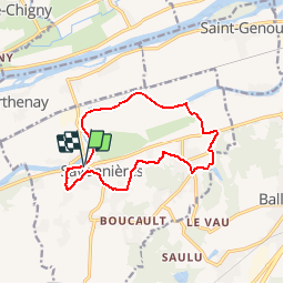
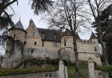
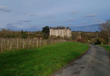
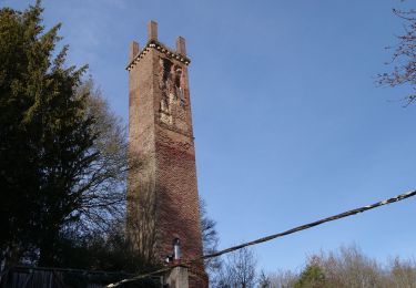
Trail Walking of 11.8 km to be discovered at Centre-Loire Valley, Indre-et-Loire, Savonnières. This trail is proposed by LEMENIO.
Description
Départ place des charmilles. La fin de parcours peut être raccourcie de 2.5 Km en filant tout droit jusqu'au bas de la rue du paradis ( entrée du bourg). Sinon tourner à gauche pour faire la boucle finale (fin de descente un peu raide).
Positioning
Country:
France
Region :
Centre-Loire Valley
Department/Province :
Indre-et-Loire
Municipality :
Savonnières
Location:
Unknown
Start:(Dec)
Start:(UTM)
314747 ; 5246792 (31T) N.
Comments
Trails nearby
![Walking Walking](https://static1.geolcdn.com/sitytour/trail-icons/101.png)
Villandry - 2015 05 24
Walking
Easy
(1)
Villandry,
Centre-Loire Valley,
Indre-et-Loire,
France
![](/images/other/stat-length.png)
4.9 km | 5.7 km-effort
1h 15min
![](https://static1.geolcdn.com/siteimages/upload/files/16400158638029165_repeat_loop_refresh_sync_direction_icon.png)
Yes
![Trail Walking Fondettes - Fondettes Vallières - Luynes Le Vieux-Bourg - 26.1km 360m 5h30 (45mn) - 2024 12 11 - Photo](https://media.geolcdn.com/t/375/260/7ea9ad8d-3a09-4814-97d4-258e1355629e.jpg&format=jpg&maxdim=2)
![Walking Walking](https://static1.geolcdn.com/sitytour/trail-icons/101.png)
Fondettes Vallières - Luynes Le Vieux-Bourg - 26.1km 360m 5h30 (45mn) - 2024 ...
Walking
Medium
Fondettes,
Centre-Loire Valley,
Indre-et-Loire,
France
![](/images/other/stat-length.png)
26 km | 31 km-effort
5h 30min
![](https://static1.geolcdn.com/siteimages/upload/files/16400158638029165_repeat_loop_refresh_sync_direction_icon.png)
Yes
![Trail Walking Savonnières - Savonnières - Zig zag Villandry - 20.7km 260m 4h25 (40mn) - 2024 06 02 - Photo](https://media.geolcdn.com/t/375/260/12f64fcc-4f3e-4220-83eb-fe5365015280.jpg&format=jpg&maxdim=2)
![Walking Walking](https://static1.geolcdn.com/sitytour/trail-icons/101.png)
Savonnières - Zig zag Villandry - 20.7km 260m 4h25 (40mn) - 2024 06 02
Walking
Easy
Savonnières,
Centre-Loire Valley,
Indre-et-Loire,
France
![](/images/other/stat-length.png)
21 km | 24 km-effort
4h 25min
![](https://static1.geolcdn.com/siteimages/upload/files/16400158638029165_repeat_loop_refresh_sync_direction_icon.png)
Yes
![Trail Walking Ballan-Miré - Ballan-Miré - Parking des Châtaigniers - 8.4km 125m 1h50 - 2024 03 06 - Photo](https://media.geolcdn.com/t/375/260/1a378f68-cb26-4349-9743-c95ed818731a.jpg&format=jpg&maxdim=2)
![Walking Walking](https://static1.geolcdn.com/sitytour/trail-icons/101.png)
Ballan-Miré - Parking des Châtaigniers - 8.4km 125m 1h50 - 2024 03 06
Walking
Medium
Ballan-Miré,
Centre-Loire Valley,
Indre-et-Loire,
France
![](/images/other/stat-length.png)
8.4 km | 10.1 km-effort
1h 50min
![](https://static1.geolcdn.com/siteimages/upload/files/16400158638029165_repeat_loop_refresh_sync_direction_icon.png)
Yes
![Trail Walking Saint-Étienne-de-Chigny - Saint-Étienne-de-Chigny - le Vieux Bourg - Luynes - 15.8km 285m 3h30 - 2024 02 28 - Photo](https://media.geolcdn.com/t/375/260/b6ad8ad7-2214-4d55-9cd7-2ee78c3b27ee.jpg&format=jpg&maxdim=2)
![Walking Walking](https://static1.geolcdn.com/sitytour/trail-icons/101.png)
Saint-Étienne-de-Chigny - le Vieux Bourg - Luynes - 15.8km 285m 3h30 - 2024 0...
Walking
Medium
Saint-Étienne-de-Chigny,
Centre-Loire Valley,
Indre-et-Loire,
France
![](/images/other/stat-length.png)
15.8 km | 19.6 km-effort
3h 30min
![](https://static1.geolcdn.com/siteimages/upload/files/16400158638029165_repeat_loop_refresh_sync_direction_icon.png)
Yes
![Trail Walking Saint-Étienne-de-Chigny - Saint-Étienne-de-Chigny - la Pile de Cinq-Mars-la-Pile - 14.2km 215m 3h15 - 2024 02 17 - Photo](https://media.geolcdn.com/t/375/260/84d699f2-9fbc-4977-9839-f8db73d27f73.jpg&format=jpg&maxdim=2)
![Walking Walking](https://static1.geolcdn.com/sitytour/trail-icons/101.png)
Saint-Étienne-de-Chigny - la Pile de Cinq-Mars-la-Pile - 14.2km 215m 3h15 - 2...
Walking
Medium
Saint-Étienne-de-Chigny,
Centre-Loire Valley,
Indre-et-Loire,
France
![](/images/other/stat-length.png)
14.5 km | 17.2 km-effort
3h 15min
![](https://static1.geolcdn.com/siteimages/upload/files/16400158638029165_repeat_loop_refresh_sync_direction_icon.png)
Yes
![Trail Walking Savonnières - Savonnières - les Fontaines GR3 et PRs - 20.1km 190m 4h40 - 2022 05 12 - Photo](https://media.geolcdn.com/t/375/260/58a53b1f-8878-4695-8af8-d5fb36baa215.jpg&format=jpg&maxdim=2)
![Walking Walking](https://static1.geolcdn.com/sitytour/trail-icons/101.png)
Savonnières - les Fontaines GR3 et PRs - 20.1km 190m 4h40 - 2022 05 12
Walking
Easy
Savonnières,
Centre-Loire Valley,
Indre-et-Loire,
France
![](/images/other/stat-length.png)
20 km | 23 km-effort
4h 40min
![](https://static1.geolcdn.com/siteimages/upload/files/16400158638029165_repeat_loop_refresh_sync_direction_icon.png)
Yes
![Trail Walking Berthenay - Berthenay - Sentier des deux Eaux - 16.3km 65m 4h00 - 2022 05 08 - Photo](https://media.geolcdn.com/t/375/260/0ed1278a-60ca-4774-800b-77548f464139.jpg&format=jpg&maxdim=2)
![Walking Walking](https://static1.geolcdn.com/sitytour/trail-icons/101.png)
Berthenay - Sentier des deux Eaux - 16.3km 65m 4h00 - 2022 05 08
Walking
Easy
Berthenay,
Centre-Loire Valley,
Indre-et-Loire,
France
![](/images/other/stat-length.png)
16.3 km | 17.2 km-effort
4h 0min
![](https://static1.geolcdn.com/siteimages/upload/files/16400158638029165_repeat_loop_refresh_sync_direction_icon.png)
Yes
![Trail Walking Saint-Étienne-de-Chigny - Saint-Étienne-de-Chigny - Pont de Bresme - 23.4km 275m 4h45 (25mn) - 2021 07 08 - Photo](https://media.geolcdn.com/t/375/260/99af599b-914a-4e89-a7d1-8d362555a6d7.jpg&format=jpg&maxdim=2)
![Walking Walking](https://static1.geolcdn.com/sitytour/trail-icons/101.png)
Saint-Étienne-de-Chigny - Pont de Bresme - 23.4km 275m 4h45 (25mn) - 2021 07 08
Walking
Easy
Saint-Étienne-de-Chigny,
Centre-Loire Valley,
Indre-et-Loire,
France
![](/images/other/stat-length.png)
23 km | 27 km-effort
4h 45min
![](https://static1.geolcdn.com/siteimages/upload/files/16400158638029165_repeat_loop_refresh_sync_direction_icon.png)
Yes