Trail Running Vesancy - Col de la Faucille par la forêt du Turet - Photo

Col de la Faucille par la forêt du Turet

 xekebo
xekebo

User

© OpenStreetMap contributors
Length
Length
17.8 km
Max alt
Max alt
1416 m
Uphill gradient
Uphill gradient
812 m
Km-Effort
Km-Effort  
29 km
Min alt
Min alt
726 m
Downhill gradient
Downhill gradient
815 m
Boucle
Boucle
Yes
Creation date :
2014-12-10 00:00:00.0
Updated on :
2014-12-10 00:00:00.0

(0 Reviews)

Running
Running
2h22
Difficulty : Difficult

Scan this QR Code to open this trail in the SityTrail application

FREE GPS app for hiking

Logo SityTrail SityTrail

IGN / Geographical institutes

Download SityTrail from the App Store Download SityTrail from Google Play

Logo SityTrail SityTrail World

The world is yours!

Download SityTrail from the App Store Download SityTrail from Google Play Download SityTrail on Huawei AppGallery

About

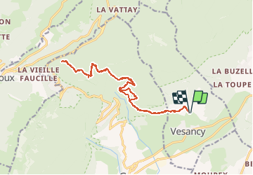
Trail Running of 17.8 km to be discovered at Auvergne-Rhône-Alpes, Ain, Vesancy. This trail is proposed by xekebo.

Description

Depuis Vesancy, prendre le sentier en direction de la forêt du Turet, prendre ensuite le chemin du creux du cerf puis la route du mauvais pas jusqu'au sommet. prendre ensuite en direction du col.

Elevation profile

Positioning

Country:
France
Region :
Auvergne-Rhône-Alpes
Department/Province :
Ain
Municipality :
Vesancy
Location:
Unknown
Start:(UTM)
276087 ; 5137500 (32T) N.

Trails nearby

Trail Walking Divonne-les-Bains - 20230521 - Divonne-les-Bains 3.8 Km - Photo
Walking
GUIDE
pierreh01

Walking

Easy
Divonne-les-Bains, Auvergne-Rhône-Alpes, Ain, France
3.8 km | 4.1 km-effort
56min
Yes
Trail Walking Divonne-les-Bains - Randonnée - Photo
Walking
GUIDE
pierreh01

Walking

Medium
Divonne-les-Bains, Auvergne-Rhône-Alpes, Ain, France
6.2 km | 9 km-effort
2h 2min
Yes
Trail Walking Gex - Le colomby de gex - Photo
Walking
tippex01

Walking

Difficult
(1)
Gex, Auvergne-Rhône-Alpes, Ain, France
14 km | 24 km-effort
4h 30min
Yes
Trail Cycle Gex - Cyclo montagnarde : par les cols franco-suisse - Gex - Photo
Cycle
tracegps

Cycle

Difficult
Gex, Auvergne-Rhône-Alpes, Ain, France
61 km | 77 km-effort
4h 0min
Yes
Trail Cycle Gex - Les jardins de l'Europe - Version courte - Gex  - Photo
Cycle
tracegps

Cycle

Medium
Gex, Auvergne-Rhône-Alpes, Ain, France
34 km | 40 km-effort
2h 0min
Yes
Trail Winter sports Mijoux -  Piste de la Petite Grand (rouge - 10,5km ) - Photo
Winter sports
otgex

Winter sports

Very easy
Mijoux, Auvergne-Rhône-Alpes, Ain, France
9.6 km | 12.4 km-effort
2h 0min
Yes
Trail Walking Gex - morilles et st georges - Photo
Walking
Texier Thierry

Walking

Very difficult
Gex, Auvergne-Rhône-Alpes, Ain, France
55 km | 66 km-effort
2h 56min
Yes
Trail Walking Gex - Colomby de Gex - Photo
Walking
perenhout

Walking

Medium
Gex, Auvergne-Rhône-Alpes, Ain, France
19.2 km | 31 km-effort
5h 51min
No
Trail sport Vesancy - Prospection morilles - Photo
sport
CCMT

sport

Very easy
Vesancy, Auvergne-Rhône-Alpes, Ain, France
4.8 km | 7.2 km-effort
Unknown
No


Close
My subscriptions