![](/images/other/stat-length.png)
![Trail Bicycle tourism Hasparren - B - Hasparren - La vallée de l'Adour - Photo](https://media.geolcdn.com/t/1900/400/ext.pjpeg?maxdim=2&url=https%3A%2F%2Fstatic1.geolcdn.com%2Fsiteimages%2Fupload%2Ffiles%2F1524743154velo.jpg)
B - Hasparren - La vallée de l'Adour
potofe
User
![Length](/images/other/stat-length.png)
Length
88 km
![Max alt](https://static1.geolcdn.com/siteimages/upload/files/1508320355ic_sort_altitude_max_24dp.png)
Max alt
186 m
![Uphill gradient](https://static1.geolcdn.com/siteimages/upload/files/1508320355ic_sort_den_pos_24dp.png)
Uphill gradient
1491 m
![Km-Effort](/images/other/stat-length.png)
Km-Effort
108 km
![Min alt](https://static1.geolcdn.com/siteimages/upload/files/1508320355ic_sort_altitude_min_24dp.png)
Min alt
-5 m
![Downhill gradient](https://static1.geolcdn.com/siteimages/upload/files/1508320355ic_sort_den_neg_24dp.png)
Downhill gradient
1499 m
![Boucle](https://static1.geolcdn.com/siteimages/upload/files/16400158638029165_repeat_loop_refresh_sync_direction_icon.png)
Boucle
Yes
Creation date :
2018-09-07 19:25:02.247
Updated on :
2024-08-15 15:05:13.656
![Bicycle tourism](https://static1.geolcdn.com/sitytour/trail-icons/204.png)
--
Difficulty : Very difficult
![Scan this QR Code to open this trail in the SityTrail application](https://capi.geolives.com/qq0zvz2zws4bq2lad0pu/sitytour/trails/119973/qr.png?size=200)
FREE GPS app for hiking
About
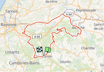
Trail Bicycle tourism of 88 km to be discovered at New Aquitaine, Pyrénées-Atlantiques, Hasparren. This trail is proposed by potofe.
Description
Vélo 64
Rando N°7
Parcours ½ journée ou journée, vallonné, pour cyclotouriste moyen (entrainement de 2 à 3000 km). Petirs braquets recommandés (28x24 ou 28x26 par exemple).
Positioning
Country:
France
Region :
New Aquitaine
Department/Province :
Pyrénées-Atlantiques
Municipality :
Hasparren
Location:
Unknown
Start:(Dec)
Start:(UTM)
637260 ; 4804895 (30T) N.
Comments
Trails nearby
![Trail Walking Hasparren - Ursuya - Photo](https://media.geolcdn.com/t/375/260/5b6594c9-7464-40b5-ab4d-e519503b5914.jpg&format=jpg&maxdim=2)
![Walking Walking](https://static1.geolcdn.com/sitytour/trail-icons/101.png)
Ursuya
Walking
Medium
(1)
Hasparren,
New Aquitaine,
Pyrénées-Atlantiques,
France
![](/images/other/stat-length.png)
10.8 km | 18.5 km-effort
3h 40min
![](https://static1.geolcdn.com/siteimages/upload/files/16400158638029165_repeat_loop_refresh_sync_direction_icon.png)
Yes
![Trail Walking Hasparren - Haitzeder boucle - Photo](https://media.geolcdn.com/t/375/260/68f2128d-058b-4818-b520-cd2bd848b62c.jpg&format=jpg&maxdim=2)
![Walking Walking](https://static1.geolcdn.com/sitytour/trail-icons/101.png)
Haitzeder boucle
Walking
Easy
(1)
Hasparren,
New Aquitaine,
Pyrénées-Atlantiques,
France
![](/images/other/stat-length.png)
8.3 km | 11.7 km-effort
2h 28min
![](https://static1.geolcdn.com/siteimages/upload/files/16400158638029165_repeat_loop_refresh_sync_direction_icon.png)
Yes
![Trail Other activity La Bastide-Clairence - Pierroun - Photo](https://media.geolcdn.com/t/375/260/ext.jpg?maxdim=2&url=https%3A%2F%2Fstatic1.geolcdn.com%2Fsiteimages%2Fupload%2Ffiles%2F1545311037marcheuse_200dpi.jpg)
![Other activity Other activity](https://static1.geolcdn.com/sitytour/trail-icons/900.png)
Pierroun
Other activity
Very easy
(1)
La Bastide-Clairence,
New Aquitaine,
Pyrénées-Atlantiques,
France
![](/images/other/stat-length.png)
8.2 km | 11.3 km-effort
2h 0min
![](https://static1.geolcdn.com/siteimages/upload/files/16400158638029165_repeat_loop_refresh_sync_direction_icon.png)
Yes
![Trail Walking Hasparren - ursuya - Photo](https://media.geolcdn.com/t/375/260/ext.jpg?maxdim=2&url=https%3A%2F%2Fstatic1.geolcdn.com%2Fsiteimages%2Fupload%2Ffiles%2F1553511878bg_sport_marche.png)
![Walking Walking](https://static1.geolcdn.com/sitytour/trail-icons/101.png)
ursuya
Walking
Very easy
(2)
Hasparren,
New Aquitaine,
Pyrénées-Atlantiques,
France
![](/images/other/stat-length.png)
13.6 km | 22 km-effort
3h 8min
![](https://static1.geolcdn.com/siteimages/upload/files/16400158638029165_repeat_loop_refresh_sync_direction_icon.png)
Yes
![Trail Walking Hasparren - landes hasparren - Photo](https://media.geolcdn.com/t/375/260/9976acab-22ed-4393-bb84-453bc9aa326f.jpg&format=jpg&maxdim=2)
![Walking Walking](https://static1.geolcdn.com/sitytour/trail-icons/101.png)
landes hasparren
Walking
Very easy
Hasparren,
New Aquitaine,
Pyrénées-Atlantiques,
France
![](/images/other/stat-length.png)
10.2 km | 13.5 km-effort
2h 44min
![](https://static1.geolcdn.com/siteimages/upload/files/16400158638029165_repeat_loop_refresh_sync_direction_icon.png)
Yes
![Trail Walking Hasparren - Boucle Pilota Plaza Hasparren Briscous - Photo](https://media.geolcdn.com/t/375/260/85b26044-56fb-4088-90ae-04fdafe6b05a.jpg&format=jpg&maxdim=2)
![Walking Walking](https://static1.geolcdn.com/sitytour/trail-icons/101.png)
Boucle Pilota Plaza Hasparren Briscous
Walking
Very easy
Hasparren,
New Aquitaine,
Pyrénées-Atlantiques,
France
![](/images/other/stat-length.png)
11.2 km | 14.3 km-effort
2h 42min
![](https://static1.geolcdn.com/siteimages/upload/files/16400158638029165_repeat_loop_refresh_sync_direction_icon.png)
Yes
![Trail On foot Hasparren - Hasparren laberi Ense - Photo](https://media.geolcdn.com/t/375/260/08a50a95-869a-4e46-aa45-84c6b2cc454e.jpg&format=jpg&maxdim=2)
![On foot On foot](https://static1.geolcdn.com/sitytour/trail-icons/100.png)
Hasparren laberi Ense
On foot
Easy
Hasparren,
New Aquitaine,
Pyrénées-Atlantiques,
France
![](/images/other/stat-length.png)
10.5 km | 13.8 km-effort
3h 7min
![](https://static1.geolcdn.com/siteimages/upload/files/16400158638029165_repeat_loop_refresh_sync_direction_icon.png)
Yes
![Trail Walking Hasparren - Ursuya Boucle - Photo](https://media.geolcdn.com/t/375/260/f9ba8e38-c272-4139-a3f1-4a05e11979b9.jpg&format=jpg&maxdim=2)
![Walking Walking](https://static1.geolcdn.com/sitytour/trail-icons/101.png)
Ursuya Boucle
Walking
Easy
Hasparren,
New Aquitaine,
Pyrénées-Atlantiques,
France
![](/images/other/stat-length.png)
11.1 km | 18.8 km-effort
4h 25min
![](https://static1.geolcdn.com/siteimages/upload/files/16400158638029165_repeat_loop_refresh_sync_direction_icon.png)
Yes
![Trail Walking Hasparren - Hasparren Sentier sculpture - Photo](https://media.geolcdn.com/t/375/260/774bd062-6a2b-4d8c-a473-6b97333b479a.jpg&format=jpg&maxdim=2)
![Walking Walking](https://static1.geolcdn.com/sitytour/trail-icons/101.png)
Hasparren Sentier sculpture
Walking
Easy
(1)
Hasparren,
New Aquitaine,
Pyrénées-Atlantiques,
France
![](/images/other/stat-length.png)
7.2 km | 9.1 km-effort
2h 14min
![](https://static1.geolcdn.com/siteimages/upload/files/16400158638029165_repeat_loop_refresh_sync_direction_icon.png)
Yes
Joli parcours, exigeant. La longue ligne droite après être passé sous l'autoroute, permet d'utiliser un peu le grand plateau et de respirer un peu. Cela équilibre cette belle sortieMerci de l'avoir partagée