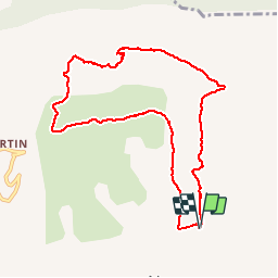
Trail Running Noyers-sur-Jabron - Tour de la Gineste - Photo
 phd04
phd04

User

© OpenStreetMap contributors
Length
Length
9.5 km
Max alt
Max alt
1054 m
Uphill gradient
Uphill gradient
484 m
Km-Effort
Km-Effort  
15.9 km
Min alt
Min alt
652 m
Downhill gradient
Downhill gradient
480 m
Boucle
Boucle
Yes
Creation date :
2014-12-10 00:00:00.0
Updated on :
2014-12-10 00:00:00.0

(0 Reviews)

Running
Running
1h46
Difficulty : Medium

Scan this QR Code to open this trail in the SityTrail application

FREE GPS app for hiking

Logo SityTrail SityTrail

IGN / Geographical institutes

Download SityTrail from the App Store Download SityTrail from Google Play

Logo SityTrail SityTrail World

The world is yours!

Download SityTrail from the App Store Download SityTrail from Google Play Download SityTrail on Huawei AppGallery

About

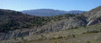
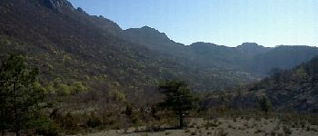
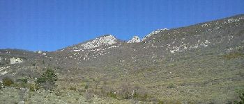
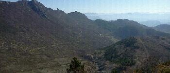
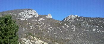
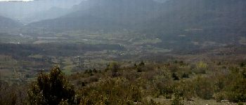
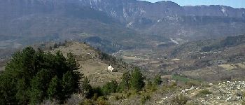
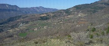
Trail Running of 9.5 km to be discovered at Provence-Alpes-Côte d'Azur, Alpes-de-Haute-Provence, Noyers-sur-Jabron. This trail is proposed by phd04.

Description

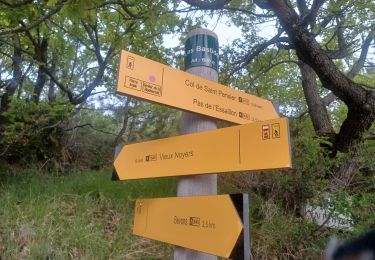
Pour rejoindre le point de départ, prendre la route du Vieux Noyers et se garer juste avant l'intersection de Durban.
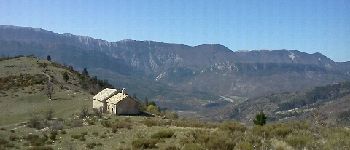
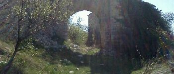
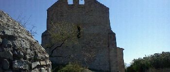
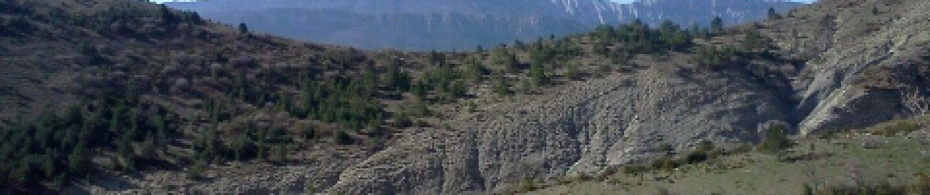
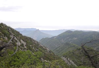
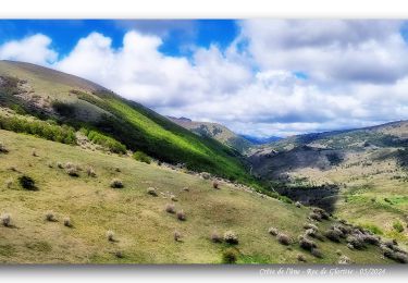
Prendre sur 2 km, la route à droite qui mène à la ferme de Durban. Laisser la ferme sur la droite et poursuivre sur la piste. Passer une première clôture de parc à mouton. Continuer jusqu'à la deuxième. (Ne pas suivre le PR - en jaune - qui part à droite). Passer la deuxième clôture. Suivre la piste jusqu'au bout où elle redescend dans le Ravin de Font de Clarette. Remonter le ravin par la droite pour atteindre la crête à la côte 1064 (point de vue). Prendre à gauche et  rester sur la crête. Trouver une clôture de parc à mouton. Puis suivre celle qui descend à droite vers la Chapelle St Claude. A la chapelle prendre le GR 946 à gauche jusqu'au village du Vieux Noyers en ruine. Traverser le village (Église romane du XIII ème). Prendre la route goudronnée; Au premier virage à droite prendre tout droit le PR (en jaune) qui descend directement sur Noyers.  A l'intersection prendre la route goudronnée à gauche jusqu'à votre véhicule.

Elevation profile

Photos

Points of interest

Point of interest Noyers-sur-Jabron - Sommet de Lure  - Photo
phd04
NOYERS-SUR-JABRON 
Point of interest Noyers-sur-Jabron - Point 2 - Photo
phd04
NOYERS-SUR-JABRON 
Point of interest Noyers-sur-Jabron - Le Rancurel - Pas de Liérette - Photo
phd04
Point of interest Noyers-sur-Jabron - Point 4 - Photo
phd04
NOYERS-SUR-JABRON 
Point of interest Noyers-sur-Jabron - Point 5 - Photo
phd04
NOYERS-SUR-JABRON 
Point of interest Noyers-sur-Jabron - Point 6 - Photo
phd04
NOYERS-SUR-JABRON 
Point of interest Noyers-sur-Jabron - Point 7 - Photo
phd04
NOYERS-SUR-JABRON 
Point of interest Noyers-sur-Jabron - Point 8 - Photo
phd04
NOYERS-SUR-JABRON 
Point of interest Noyers-sur-Jabron - Point 9 - Photo
phd04
NOYERS-SUR-JABRON 
Point of interest Noyers-sur-Jabron - Point 10 - Photo
phd04
NOYERS-SUR-JABRON 
Point of interest Noyers-sur-Jabron - Point 11 - Photo
phd04
NOYERS-SUR-JABRON 

Positioning

Country:
France
Region :
Provence-Alpes-Côte d'Azur
Department/Province :
Alpes-de-Haute-Provence
Municipality :
Noyers-sur-Jabron
Location:
Unknown
Start:(UTM)
726385 ; 4895281 (31T) N.

Trails nearby

Trail Walking Valbelle - Valbelle - Chapelle Saint Pons - Photo
Walking
GUIDE
R@ph

Walking

Medium
(1)
Valbelle, Provence-Alpes-Côte d'Azur, Alpes-de-Haute-Provence, France
5.5 km | 10.6 km-effort
2h 20min
Yes
Trail Walking Val-Buëch-Méouge - Crête de l'âne, des Planes et Roc de Gloritte Via Plaugiers - Photo
Walking
PapouBertrand

Walking

Very difficult
Val-Buëch-Méouge, Provence-Alpes-Côte d'Azur, Hautes-Alpes, France
11.1 km | 23 km-effort
5h 19min
Yes
Trail Walking Noyers-sur-Jabron - Pas du long Rocher - Montagne de Pélegrine - Pas des portes 18/02/24 - Photo
Walking
GUIDE
R@ph

Walking

Very difficult
Noyers-sur-Jabron, Provence-Alpes-Côte d'Azur, Alpes-de-Haute-Provence, France
19.3 km | 32 km-effort
7h 15min
Yes
Trail Walking Valbelle -  Chapelle St Pons  - Photo
Walking
cousam

Walking

Difficult
Valbelle, Provence-Alpes-Côte d'Azur, Alpes-de-Haute-Provence, France
8.4 km | 14.3 km-effort
3h 29min
Yes
Trail Walking Valbelle - 04 chapelle St Pons 03.08.23 - Photo
Walking
randodyssée

Walking

Difficult
Valbelle, Provence-Alpes-Côte d'Azur, Alpes-de-Haute-Provence, France
8.2 km | 13.6 km-effort
3h 27min
No
Trail Walking Val-Buëch-Méouge - Rocher de pierre Impie, roc de l'aigle,  pas de Berches  - Photo
Walking
nadd73

Walking

Medium
Val-Buëch-Méouge, Provence-Alpes-Côte d'Azur, Hautes-Alpes, France
12.4 km | 23 km-effort
6h 1min
No
Trail Walking Valbelle - cirque de Valbelle  - Photo
Walking
marie04

Walking

Very difficult
Valbelle, Provence-Alpes-Côte d'Azur, Alpes-de-Haute-Provence, France
18.4 km | 31 km-effort
7h 4min
Yes
Trail Walking Noyers-sur-Jabron - SityTrail - NOYERS SUR JABRON  , S Martin  , col S Pierre , cretes de l ane n - Photo
Walking
Marco05

Walking

Difficult
Noyers-sur-Jabron, Provence-Alpes-Côte d'Azur, Alpes-de-Haute-Provence, France
13.3 km | 24 km-effort
5h 28min
Yes
Trail Walking Noyers-sur-Jabron - Les Chapelles du vieux Noyer - Photo
Walking
liocol

Walking

Medium
Noyers-sur-Jabron, Provence-Alpes-Côte d'Azur, Alpes-de-Haute-Provence, France
10.6 km | 16.6 km-effort
4h 2min
Yes


Close
My subscriptions