![](/images/other/stat-length.png)
![Trail Walking Ota - Ota - Barghiana - Photo](https://media.geolcdn.com/t/1900/400/ext.pjpeg?maxdim=2&url=https%3A%2F%2Fservices.sitytrail.com%2FGeolivesWS%2FDownloadMedia.ashx%3FTrailID%3D118841%26Media%3D13057_6.jpg)
Ota - Barghiana
tracegps
User
![Length](/images/other/stat-length.png)
![Max alt](https://static1.geolcdn.com/siteimages/upload/files/1508320355ic_sort_altitude_max_24dp.png)
![Uphill gradient](https://static1.geolcdn.com/siteimages/upload/files/1508320355ic_sort_den_pos_24dp.png)
![Km-Effort](/images/other/stat-length.png)
![Min alt](https://static1.geolcdn.com/siteimages/upload/files/1508320355ic_sort_altitude_min_24dp.png)
![Downhill gradient](https://static1.geolcdn.com/siteimages/upload/files/1508320355ic_sort_den_neg_24dp.png)
![Boucle](https://static1.geolcdn.com/siteimages/upload/files/16400158638029165_repeat_loop_refresh_sync_direction_icon.png)
![Walking](https://static1.geolcdn.com/sitytour/trail-icons/101.png)
30h00
Difficulty : Very difficult
![Scan this QR Code to open this trail in the SityTrail application](https://capi.geolives.com/qq0zvz2zws4bq2lad0pu/sitytour/trails/118841/qr.png?size=200)
FREE GPS app for hiking
About
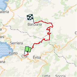
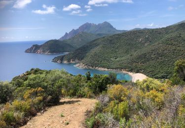
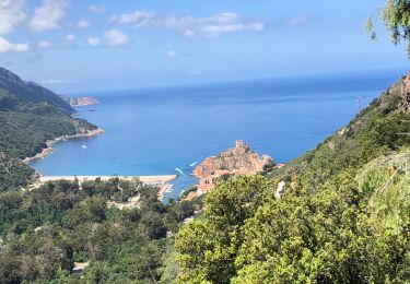
Trail Walking of 49 km to be discovered at Corsica, South Corsica, Ota. This trail is proposed by tracegps.
Description
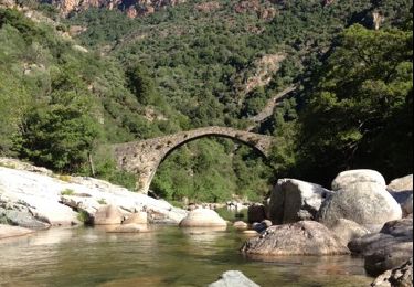
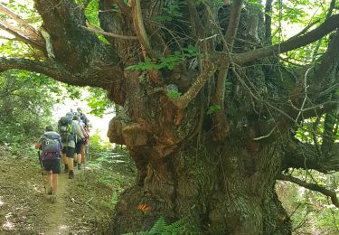
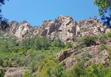
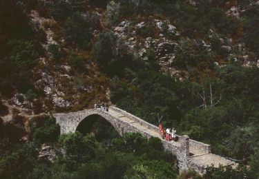
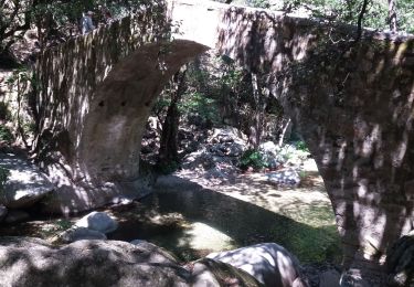
Ce trek relie Ota (près de Porto) à Barghiana (près de Galeria) en empruntant un itinéraire très original dans une des régions les plus sauvages de Corse. Il a été réalisé avec quatre bivouacs (Refuges de Puscaghia et de Ciottulu di i Mori, et nuits au pied du Tafunatu, et aux bergeries de Laoscella). Attention, si la trace GPS doit permettre de ne pas se perdre, quelques passages, sans être techniques, sont à la limite de la randonnée, d'autant plus qu'un sac à dos conséquent est nécessaire. Tous les détails sur cette page.
Points of interest
Positioning
Comments
Trails nearby
![Trail Walking Serriera - Mare e Monti - De Serriera à Ota - Photo](https://media.geolcdn.com/t/375/260/ext.jpg?maxdim=2&url=https%3A%2F%2Fservices.sitytrail.com%2FGeolivesWS%2FDownloadMedia.ashx%3FTrailID%3D109780%26Media%3D4710_1.jpg)
![Walking Walking](https://static1.geolcdn.com/sitytour/trail-icons/101.png)
Walking
![](/images/other/stat-length.png)
![](https://static1.geolcdn.com/siteimages/upload/files/16400158638029165_repeat_loop_refresh_sync_direction_icon.png)
![Trail Walking Ota - Gorge de spelunca - Photo](https://media.geolcdn.com/t/375/260/f6804445-15a3-4e4f-812b-febb15caa6ee.jpg&format=jpg&maxdim=2)
![Walking Walking](https://static1.geolcdn.com/sitytour/trail-icons/101.png)
![Trail Walking Ota - gorges de la spelunca et pont, ota, corse - Photo](https://media.geolcdn.com/t/375/260/ext.jpg?maxdim=2&url=https%3A%2F%2Fservices.sitytrail.com%2FGeolivesWS%2FDownloadMedia.ashx%3FTrailID%3D209384%26Media%3D20130801094128.jpg)
![Walking Walking](https://static1.geolcdn.com/sitytour/trail-icons/101.png)
Walking
![](/images/other/stat-length.png)
![](https://static1.geolcdn.com/siteimages/upload/files/16400158638029165_repeat_loop_refresh_sync_direction_icon.png)
![Trail Walking Ota - Ota Mariniana - Photo](https://media.geolcdn.com/t/375/260/b92651dc-1968-4d40-9564-f6b44744830a.jpg&format=jpg&maxdim=2)
![Walking Walking](https://static1.geolcdn.com/sitytour/trail-icons/101.png)
![Trail Walking Serriera - Serierra Ota - Photo](https://media.geolcdn.com/t/375/260/e7fdd3ae-25cd-4c33-9101-c2858a640faa.jpg&format=jpg&maxdim=2)
![Walking Walking](https://static1.geolcdn.com/sitytour/trail-icons/101.png)
Walking
![](/images/other/stat-length.png)
![](https://static1.geolcdn.com/siteimages/upload/files/16400158638029165_repeat_loop_refresh_sync_direction_icon.png)
![Trail On foot Ota - Ota canyons - Photo](https://media.geolcdn.com/t/375/260/4dad7e61-defe-4494-9d4b-3248fec98a02.jpeg&format=jpg&maxdim=2)
![On foot On foot](https://static1.geolcdn.com/sitytour/trail-icons/100.png)
![Trail Walking Évisa - gorges spelunca - Photo](https://media.geolcdn.com/t/375/260/2ba82175-16ea-471a-af7d-9a429f43496d.jpg&format=jpg&maxdim=2)
![Walking Walking](https://static1.geolcdn.com/sitytour/trail-icons/101.png)
Walking
![](/images/other/stat-length.png)
![](https://static1.geolcdn.com/siteimages/upload/files/16400158638029165_repeat_loop_refresh_sync_direction_icon.png)
![Trail Walking Serriera - 20210608 Serriera - Gradelle - Photo](https://media.geolcdn.com/t/375/260/ea9dba27-4698-47fa-9b83-768439d3b81a.jpg&format=jpg&maxdim=2)
![Walking Walking](https://static1.geolcdn.com/sitytour/trail-icons/101.png)
Walking
![](/images/other/stat-length.png)
![](https://static1.geolcdn.com/siteimages/upload/files/16400158638029165_repeat_loop_refresh_sync_direction_icon.png)
![Trail Walking Ota - 20210607 de Otta a Bussaghia- balcons de Porto - Photo](https://media.geolcdn.com/t/375/260/3d6c3fdf-cc74-4e9a-ba21-7c75e8e28103.jpg&format=jpg&maxdim=2)
![Walking Walking](https://static1.geolcdn.com/sitytour/trail-icons/101.png)
Walking
![](/images/other/stat-length.png)
![](https://static1.geolcdn.com/siteimages/upload/files/16400158638029165_repeat_loop_refresh_sync_direction_icon.png)