![](/images/other/stat-length.png)
![Trail Mountain bike Bédoin - Bédoin au pied du Mont Ventoux - Photo](https://media.geolcdn.com/t/1900/400/ext.pjpeg?maxdim=2&url=https%3A%2F%2Fservices.sitytrail.com%2FGeolivesWS%2FDownloadMedia.ashx%3FTrailID%3D118760%26Media%3D12957_2.jpg)
Bédoin au pied du Mont Ventoux
tracegps
User
![Length](/images/other/stat-length.png)
![Max alt](https://static1.geolcdn.com/siteimages/upload/files/1508320355ic_sort_altitude_max_24dp.png)
![Uphill gradient](https://static1.geolcdn.com/siteimages/upload/files/1508320355ic_sort_den_pos_24dp.png)
![Km-Effort](/images/other/stat-length.png)
![Min alt](https://static1.geolcdn.com/siteimages/upload/files/1508320355ic_sort_altitude_min_24dp.png)
![Downhill gradient](https://static1.geolcdn.com/siteimages/upload/files/1508320355ic_sort_den_neg_24dp.png)
![Boucle](https://static1.geolcdn.com/siteimages/upload/files/16400158638029165_repeat_loop_refresh_sync_direction_icon.png)
![Mountain bike](https://static1.geolcdn.com/sitytour/trail-icons/202.png)
3h00
Difficulty : Difficult
![Scan this QR Code to open this trail in the SityTrail application](https://capi.geolives.com/qq0zvz2zws4bq2lad0pu/sitytour/trails/118760/qr.png?size=200)
FREE GPS app for hiking
About
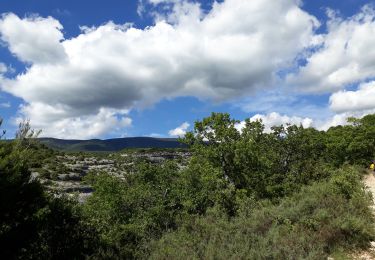
Trail Mountain bike of 26 km to be discovered at Provence-Alpes-Côte d'Azur, Vaucluse, Bédoin. This trail is proposed by tracegps.
Description
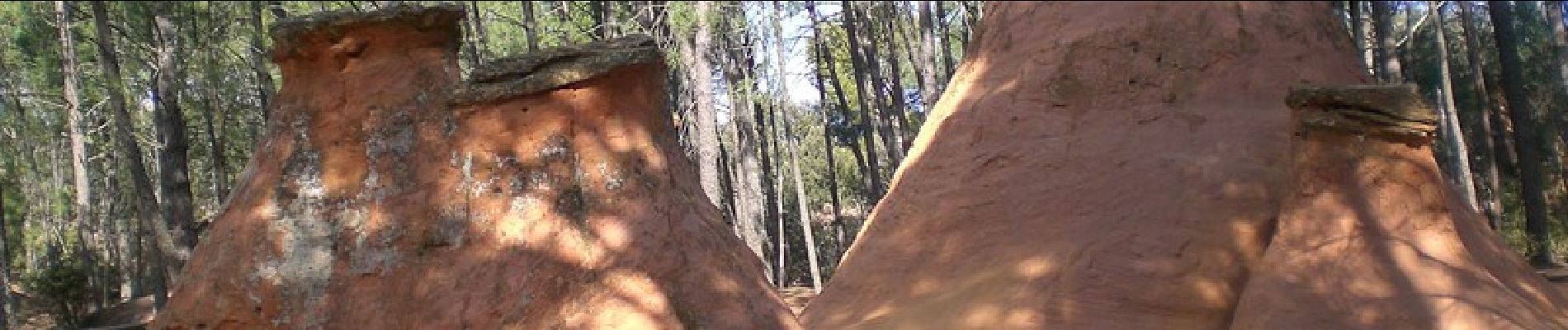
Boucle autour de Bédoin, au pied du Mt-Ventoux. Vous partirez du parking de la piscine de Bédoin, chemin des sablières, pour rejoindre tranquillement la chapelle de la Madeleine par un chemin caillouteux puis une petite route goudronnée. Echauffement terminé. Au niveau de la chapelle vous quitterez la route pour rejoindre le GR91 (trait rouge et blanc) qui vous mènera jusqu'à Flassan. Cette portion longue de 10,800km, en monotrace au début est assez exigeante sur les premiers 3,4km jusqu'à la combe de Maraval. Poussages et petits portages sont nécessaires sur de courtes distances puis à partir de la combe de Maraval cela devient une piste dfci qui se transforme un peu plus loin en sentier forestier. Cette deuxième partie du GR91 qui serpente au pied du Ventoux est plus tranquille même si par moment quelques petites montées feront descendre du vélo les moins entrainés. De magnifiques panoramas sur votre droite. Arrivés au niveau de Flassan vous reprendrez la direction de Bédoin en passant par des petits hameaux comme Saint-Estève, Sainte-Colombe, les Baux. De temps à autres sur votre gauche le sommet du Mt-Ventoux vous surveille... Vous trouverez un point d'eau à St-Estève et un autre à Ste-Colombe en bordure de parcours sur le retour. Vous passerez ensuite dans le magnifique site des Demoiselles Coiffées. Attention endroits très fragiles qu'il faut absolument respecter, ne vous écartez pas du tracé en vtt, merci! Plus loin des monotraces en forêt vous attendent dans différentes collines proches de Bédoin. Parcours sans grande difficulté technique, un peu exigeant au début sur 3,4km mais une bonne balade dans ce cadre magnifique du Mont-Ventoux qui demande quand même un certain entrainement physique. Les ados entrainés peuvent accompagner leurs parents. Bonne randonnée !!
Positioning
Comments
Trails nearby
![Trail Walking Bédoin - DEMOISELLES COIFFEES A BEDOIN - Photo](https://media.geolcdn.com/t/375/260/019fb321-209a-41dd-ae41-5842e06d9c3c.jpg&format=jpg&maxdim=2)
![Walking Walking](https://static1.geolcdn.com/sitytour/trail-icons/101.png)
Walking
![](/images/other/stat-length.png)
![](https://static1.geolcdn.com/siteimages/upload/files/16400158638029165_repeat_loop_refresh_sync_direction_icon.png)
![Trail Walking Bédoin - Le Mont Ventoux en randonnée par Saint Colombe - Photo](https://media.geolcdn.com/t/375/260/ext.jpg?maxdim=2&url=https%3A%2F%2Fservices.sitytrail.com%2FGeolivesWS%2FDownloadMedia.ashx%3FTrailID%3D317282%26Media%3D16469_1.jpg)
![Walking Walking](https://static1.geolcdn.com/sitytour/trail-icons/101.png)
Walking
![](/images/other/stat-length.png)
![](https://static1.geolcdn.com/siteimages/upload/files/16400158638029165_repeat_loop_refresh_sync_direction_icon.png)
![Trail Walking Mormoiron - Balladounette d après fêtes 🥳 - Photo](https://media.geolcdn.com/t/375/260/ecd5d04a-a53f-4421-b56c-9619fa1eb2e3.jpg&format=jpg&maxdim=2)
![Walking Walking](https://static1.geolcdn.com/sitytour/trail-icons/101.png)
Walking
![](/images/other/stat-length.png)
![](https://static1.geolcdn.com/siteimages/upload/files/16400158638029165_repeat_loop_refresh_sync_direction_icon.png)
![Trail Mountain bike Bédoin - Crillon Z'ensemble - Photo](https://media.geolcdn.com/t/375/260/9ac99583-ffb3-4a3d-a385-506d4b853f64.jpg&format=jpg&maxdim=2)
![Mountain bike Mountain bike](https://static1.geolcdn.com/sitytour/trail-icons/202.png)
Mountain bike
![](/images/other/stat-length.png)
![](https://static1.geolcdn.com/siteimages/upload/files/16400158638029165_repeat_loop_refresh_sync_direction_icon.png)
![Trail Walking Crillon-le-Brave - Torrent Pied Blanc / Rocher de la Madeleine - Photo](https://media.geolcdn.com/t/375/260/3e6e01ec-58ac-4090-bfea-a9164d2e0785.jpg&format=jpg&maxdim=2)
![Walking Walking](https://static1.geolcdn.com/sitytour/trail-icons/101.png)
Walking
![](/images/other/stat-length.png)
![](https://static1.geolcdn.com/siteimages/upload/files/16400158638029165_repeat_loop_refresh_sync_direction_icon.png)
![Trail Walking Bédoin - Baume du Chat final par les Siarres - Photo](https://media.geolcdn.com/t/375/260/4fd782e1-4328-4855-b0d0-bdb9d12f34a6.jpg&format=jpg&maxdim=2)
![Walking Walking](https://static1.geolcdn.com/sitytour/trail-icons/101.png)
Walking
![](/images/other/stat-length.png)
![](https://static1.geolcdn.com/siteimages/upload/files/16400158638029165_repeat_loop_refresh_sync_direction_icon.png)
![Trail Walking Caromb - Les 3 Termes 449 le Groseau - Photo](https://media.geolcdn.com/t/375/260/10d32099-293b-4d37-bbde-b3ecd67a6725.jpg&format=jpg&maxdim=2)
![Walking Walking](https://static1.geolcdn.com/sitytour/trail-icons/101.png)
Walking
![](/images/other/stat-length.png)
![](https://static1.geolcdn.com/siteimages/upload/files/16400158638029165_repeat_loop_refresh_sync_direction_icon.png)
![Trail Walking Bédoin - Sud Ventoux et Combe de Curnier - Photo](https://media.geolcdn.com/t/375/260/602f2a4d-f129-412a-82dd-550430a8c0db.jpg&format=jpg&maxdim=2)
![Walking Walking](https://static1.geolcdn.com/sitytour/trail-icons/101.png)
Walking
![](/images/other/stat-length.png)
![](https://static1.geolcdn.com/siteimages/upload/files/16400158638029165_repeat_loop_refresh_sync_direction_icon.png)
![Trail Walking Bédoin - P.Partie Ventoux sud - Photo](https://media.geolcdn.com/t/375/260/ext.jpg?maxdim=2&url=https%3A%2F%2Fservices.sitytrail.com%2FGeolivesWS%2FDownloadMedia.ashx%3FTrailID%3D265763%26Media%3D352fd07e-8a96-4aed-a943-ee1930eb91a7.jpg)
![Walking Walking](https://static1.geolcdn.com/sitytour/trail-icons/101.png)
Walking
![](/images/other/stat-length.png)
![](https://static1.geolcdn.com/siteimages/upload/files/16400158638029165_repeat_loop_refresh_sync_direction_icon.png)