![](/images/other/stat-length.png)
![Trail Running Cergy - Les Bords de l'Oise et la Passerelle de l'Axe Majeur - Port Cergy - Photo](https://media.geolcdn.com/t/1900/400/ext.pjpeg?maxdim=2&url=https%3A%2F%2Fservices.sitytrail.com%2FGeolivesWS%2FDownloadMedia.ashx%3FTrailID%3D118750%26Media%3D12946_6.jpg)
Les Bords de l'Oise et la Passerelle de l'Axe Majeur - Port Cergy
tracegps
User
![Length](/images/other/stat-length.png)
![Max alt](https://static1.geolcdn.com/siteimages/upload/files/1508320355ic_sort_altitude_max_24dp.png)
![Uphill gradient](https://static1.geolcdn.com/siteimages/upload/files/1508320355ic_sort_den_pos_24dp.png)
![Km-Effort](/images/other/stat-length.png)
![Min alt](https://static1.geolcdn.com/siteimages/upload/files/1508320355ic_sort_altitude_min_24dp.png)
![Downhill gradient](https://static1.geolcdn.com/siteimages/upload/files/1508320355ic_sort_den_neg_24dp.png)
![Boucle](https://static1.geolcdn.com/siteimages/upload/files/16400158638029165_repeat_loop_refresh_sync_direction_icon.png)
![Running](https://static1.geolcdn.com/sitytour/trail-icons/103.png)
30m
Difficulty : Easy
![Scan this QR Code to open this trail in the SityTrail application](https://capi.geolives.com/qq0zvz2zws4bq2lad0pu/sitytour/trails/118750/qr.png?size=200)
FREE GPS app for hiking
About
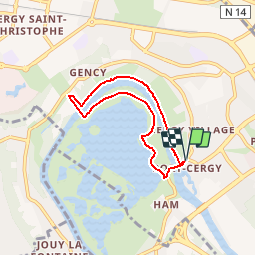
Trail Running of 5.2 km to be discovered at Ile-de-France, Val-d'Oise, Cergy. This trail is proposed by tracegps.
Description
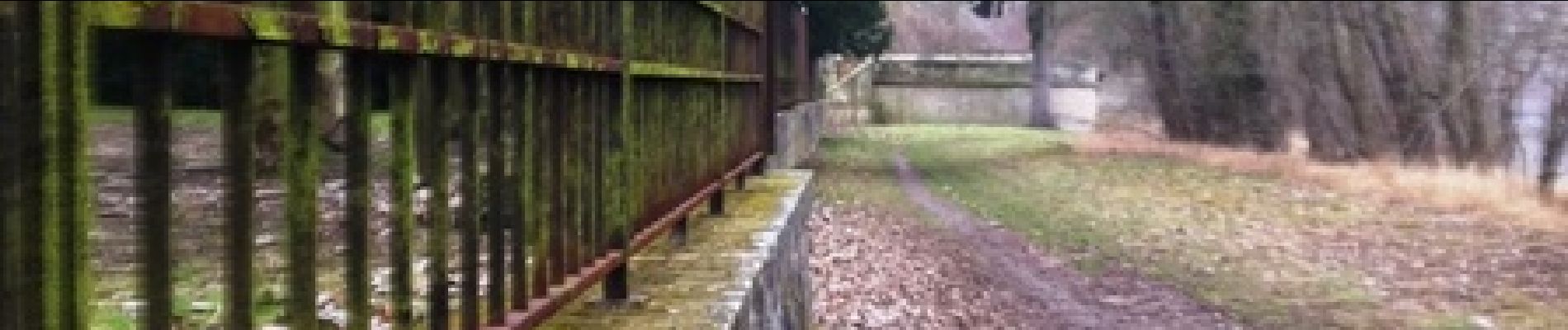
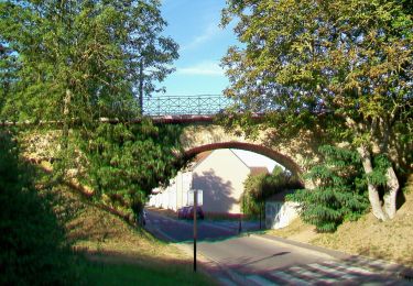
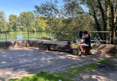
Départ de Port-Cergy en direction de la base de loisirs de Cergy Neuville. Anciennes sablières d’EDF reconverties en lieu de promenade très couru – jeu de mots !!! On longe le lac sur des chemins larges et bien tracés. Passerelle de l’Axe-Majeur, d’un rouge vif elle est uniquement piétonne et permet de traverser l’Oise. Retour par le chemin de contre-halage des berges de l’Oise, emprunté autrefois par les hommes et les chevaux accompagnant les bateaux qui descendaient la rivière. Passage près du Lavoir de la Guêpière puis on chemine le long des grilles de la Maison Gérard Philippe avant de retrouver Port Cergy. Belle balade qui peut être démultipliée tant les chemins sont nombreux. Pas de dénivelé.
Positioning
Comments
Trails nearby
![Trail On foot Conflans-Sainte-Honorine - Version définitive Conflans 7 janvier - Photo](https://media.geolcdn.com/t/375/260/2f5b666a-1419-402d-9c3e-8de986f24ebf.jpg&format=jpg&maxdim=2)
![On foot On foot](https://static1.geolcdn.com/sitytour/trail-icons/100.png)
On foot
![](/images/other/stat-length.png)
![](https://static1.geolcdn.com/siteimages/upload/files/16400158638029165_repeat_loop_refresh_sync_direction_icon.png)
![Trail Walking Pontoise - GRP CV-IDF 2023 - Photo](https://media.geolcdn.com/t/375/260/5cecfad9-3425-44be-8077-e3aed6f072e1.jpg&format=jpg&maxdim=2)
![Walking Walking](https://static1.geolcdn.com/sitytour/trail-icons/101.png)
Walking
![](/images/other/stat-length.png)
![](https://static1.geolcdn.com/siteimages/upload/files/16400158638029165_repeat_loop_refresh_sync_direction_icon.png)
![Trail Walking Jouy-le-Moutier - GRP CV-IDF 2023 - Photo](https://media.geolcdn.com/t/375/260/6d7dbb85-8194-44c4-a991-493315d817a9.jpg&format=jpg&maxdim=2)
![Walking Walking](https://static1.geolcdn.com/sitytour/trail-icons/101.png)
Walking
![](/images/other/stat-length.png)
![](https://static1.geolcdn.com/siteimages/upload/files/16400158638029165_repeat_loop_refresh_sync_direction_icon.png)
![Trail On foot Cergy - LES BALADES DE L’ÉTÉ # 9 / DE L’AXE MAJEUR À PORT CERGY - Photo](https://media.geolcdn.com/t/375/260/0abd8c0c-1f20-444a-8fa9-27c91da3cbd0.jpeg&format=jpg&maxdim=2)
![On foot On foot](https://static1.geolcdn.com/sitytour/trail-icons/100.png)
On foot
![](/images/other/stat-length.png)
![](https://static1.geolcdn.com/siteimages/upload/files/16400158638029165_repeat_loop_refresh_sync_direction_icon.png)
![Trail On foot Conflans-Sainte-Honorine - Conflans fin d'oise - Andresy - La Frette - Photo](https://media.geolcdn.com/t/375/260/43572d18-a869-49dd-98f4-125a083ecdd2.jpg&format=jpg&maxdim=2)
![On foot On foot](https://static1.geolcdn.com/sitytour/trail-icons/100.png)
On foot
![](/images/other/stat-length.png)
![](https://static1.geolcdn.com/siteimages/upload/files/16400158638029165_repeat_loop_refresh_sync_direction_icon.png)
![Trail Walking Pontoise - Le tour du grand Paris via le GR1 Etape 5 Pontoise- L'isle Adam - Photo](https://media.geolcdn.com/t/375/260/07b6ba80-b018-4e04-a1a3-6a0196965773.jpg&format=jpg&maxdim=2)
![Walking Walking](https://static1.geolcdn.com/sitytour/trail-icons/101.png)
Walking
![](/images/other/stat-length.png)
![](https://static1.geolcdn.com/siteimages/upload/files/16400158638029165_repeat_loop_refresh_sync_direction_icon.png)
![Trail On foot Cergy - Le Fil d'Ariane - Photo](https://media.geolcdn.com/t/375/260/99555ae7-7473-4890-8cc1-181c61a69de2.jpeg&format=jpg&maxdim=2)
![On foot On foot](https://static1.geolcdn.com/sitytour/trail-icons/100.png)
On foot
![](/images/other/stat-length.png)
![](https://static1.geolcdn.com/siteimages/upload/files/16400158638029165_repeat_loop_refresh_sync_direction_icon.png)
![Trail On foot Cergy - Bords d'Oise Eragny - Port Cergy - Photo](https://media.geolcdn.com/t/375/260/b35f55a1-55cf-41a0-a75c-3f85248a60dd.jpeg&format=jpg&maxdim=2)
![On foot On foot](https://static1.geolcdn.com/sitytour/trail-icons/100.png)
On foot
![](/images/other/stat-length.png)
![](https://static1.geolcdn.com/siteimages/upload/files/16400158638029165_repeat_loop_refresh_sync_direction_icon.png)
![Trail Walking Neuville-sur-Oise - base losir cergy - Photo](https://media.geolcdn.com/t/375/260/ext.jpg?maxdim=2&url=https%3A%2F%2Fstatic1.geolcdn.com%2Fsiteimages%2Fupload%2Ffiles%2F1553511878bg_sport_marche.png)
![Walking Walking](https://static1.geolcdn.com/sitytour/trail-icons/101.png)
Walking
![](/images/other/stat-length.png)
![](https://static1.geolcdn.com/siteimages/upload/files/16400158638029165_repeat_loop_refresh_sync_direction_icon.png)
Très belle balade surtout la partie du chemin de contre-halage et la découverte émouvante de la maison de Gérard Philippe. Une balade courte qui permet pour les gens du coin de voir d'un autre angle des choses habituelles.