![](/images/other/stat-length.png)
![Trail Walking Fallon - Sentier de la Mirabelle (Grande boucle) - Fallon - Photo](https://media.geolcdn.com/t/1900/400/ext.pjpeg?maxdim=2&url=https%3A%2F%2Fservices.sitytrail.com%2FGeolivesWS%2FDownloadMedia.ashx%3FTrailID%3D118731%26Media%3D12924_6.jpg)
Sentier de la Mirabelle (Grande boucle) - Fallon
tracegps
User
![Length](/images/other/stat-length.png)
![Max alt](https://static1.geolcdn.com/siteimages/upload/files/1508320355ic_sort_altitude_max_24dp.png)
![Uphill gradient](https://static1.geolcdn.com/siteimages/upload/files/1508320355ic_sort_den_pos_24dp.png)
![Km-Effort](/images/other/stat-length.png)
![Min alt](https://static1.geolcdn.com/siteimages/upload/files/1508320355ic_sort_altitude_min_24dp.png)
![Downhill gradient](https://static1.geolcdn.com/siteimages/upload/files/1508320355ic_sort_den_neg_24dp.png)
![Boucle](https://static1.geolcdn.com/siteimages/upload/files/16400158638029165_repeat_loop_refresh_sync_direction_icon.png)
![Walking](https://static1.geolcdn.com/sitytour/trail-icons/101.png)
4h00
Difficulty : Difficult
![Scan this QR Code to open this trail in the SityTrail application](https://capi.geolives.com/qq0zvz2zws4bq2lad0pu/sitytour/trails/118731/qr.png?size=200)
FREE GPS app for hiking
About
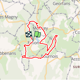
Trail Walking of 14.8 km to be discovered at Bourgogne-Franche-Comté, Haute-Saône, Fallon. This trail is proposed by tracegps.
Description
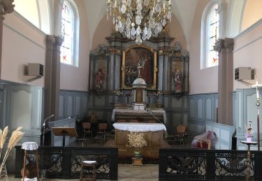
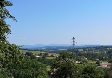
Territoire constitué de 33 communes, le pays de Villersexel est niché dans un écrin de verdure dans le département nord de la Franche-Comté. Situé en Haute-Saône, Villersexel se trouve près de l'Alsace, des Vosges, de l'Allemagne et de la Suisse. Dans un cadre préservé, venez vivre des sensations authentiques au cœur de grands espaces. De nombreux loisirs (canoë-Kayak dans la vallée de l'Ognon, randonnée pédestre, cyclotourisme, pêche) et un riche patrimoine culturel s'offrent à vous. Balade agréable avec de nombreux points de vue (Motte de Grammont) et paysages variés. Parcours jalonné de tables de lecture et table d'orientation sur la Motte de Grammont. Départ depuis la place de la Libération à FALLON. La balise pour le sentier de la mirabelle est mi-mirabelle, mi-oiseau. C’est le logo du syndicat des producteurs de mirabelles. Le syndicat produit des mirabelles bios, en n’utilisant pas de produits phytosanitaires. C’est le torcol fourmilier (l’oiseau) qui se nourrit des parasites de l’arbre qui permet cette agriculture raisonnée. C’est pourquoi le symbole représente la mirabelle et le torcol fourmilier. Un Topoguide est disponible gratuitement à l'office de tourisme du Pays de Villersexel.
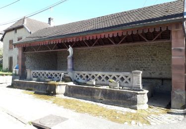
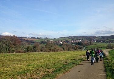
Positioning
Comments
Trails nearby
![Trail Walking Mélecey - Melecey-Fallon - Photo](https://media.geolcdn.com/t/375/260/cd352496-c2e1-4093-9ec7-a9f2a6ce20a2.jpg&format=jpg&maxdim=2)
![Walking Walking](https://static1.geolcdn.com/sitytour/trail-icons/101.png)
Walking
![](/images/other/stat-length.png)
![](https://static1.geolcdn.com/siteimages/upload/files/16400158638029165_repeat_loop_refresh_sync_direction_icon.png)
![Trail Walking Mélecey - Sur la route du fer et des mirabelles - Photo](https://media.geolcdn.com/t/375/260/ext.jpg?maxdim=2&url=https%3A%2F%2Fservices.sitytrail.com%2FGeolivesWS%2FDownloadMedia.ashx%3FTrailID%3D493781%26Media%3Dfix__20151114121220.jpg)
![Walking Walking](https://static1.geolcdn.com/sitytour/trail-icons/101.png)
Walking
![](/images/other/stat-length.png)
![](https://static1.geolcdn.com/siteimages/upload/files/16400158638029165_repeat_loop_refresh_sync_direction_icon.png)
![Trail Walking Fallon - Sentier de la Mirabelle (Petite boucle) - Fallon - Photo](https://media.geolcdn.com/t/375/260/ext.jpg?maxdim=2&url=https%3A%2F%2Fservices.sitytrail.com%2FGeolivesWS%2FDownloadMedia.ashx%3FTrailID%3D118707%26Media%3D12882_6.jpg)
![Walking Walking](https://static1.geolcdn.com/sitytour/trail-icons/101.png)
Walking
![](/images/other/stat-length.png)
![](https://static1.geolcdn.com/siteimages/upload/files/16400158638029165_repeat_loop_refresh_sync_direction_icon.png)
![Trail Walking Fallon - Randonnée des mirabelles -FALLON - Photo](https://media.geolcdn.com/t/375/260/058704d7-1375-43b4-96f9-4e55e4c42d49.jpg&format=jpg&maxdim=2)
![Walking Walking](https://static1.geolcdn.com/sitytour/trail-icons/101.png)
Walking
![](/images/other/stat-length.png)
![](https://static1.geolcdn.com/siteimages/upload/files/16400158638029165_repeat_loop_refresh_sync_direction_icon.png)
![Trail Walking Mélecey - du fer au Mirabelles - Photo](https://media.geolcdn.com/t/375/260/a7903346-cb12-4f59-bf56-513d70c886a5.jpg&format=jpg&maxdim=2)
![Walking Walking](https://static1.geolcdn.com/sitytour/trail-icons/101.png)
Walking
![](/images/other/stat-length.png)
![](https://static1.geolcdn.com/siteimages/upload/files/16400158638029165_repeat_loop_refresh_sync_direction_icon.png)
![Trail Walking Villers-la-Ville - villes la ville 2 - Photo](https://media.geolcdn.com/t/375/260/ext.jpg?maxdim=2&url=https%3A%2F%2Fstatic1.geolcdn.com%2Fsiteimages%2Fupload%2Ffiles%2F1553511878bg_sport_marche.png)
![Walking Walking](https://static1.geolcdn.com/sitytour/trail-icons/101.png)
Walking
![](/images/other/stat-length.png)
![](https://static1.geolcdn.com/siteimages/upload/files/16400158638029165_repeat_loop_refresh_sync_direction_icon.png)
![Trail On foot Mélecey - Mélecey - Photo](https://media.geolcdn.com/t/375/260/ext.jpg?maxdim=2&url=https%3A%2F%2Fstatic1.geolcdn.com%2Fsiteimages%2Fupload%2Ffiles%2F1545311037marcheuse_200dpi.jpg)
![On foot On foot](https://static1.geolcdn.com/sitytour/trail-icons/100.png)
On foot
![](/images/other/stat-length.png)
![](https://static1.geolcdn.com/siteimages/upload/files/16400158638029165_repeat_loop_refresh_sync_direction_icon.png)
![Trail Walking Villers-la-Ville - Villers la Ville 2 - Photo](https://media.geolcdn.com/t/375/260/ext.jpg?maxdim=2&url=https%3A%2F%2Fstatic1.geolcdn.com%2Fsiteimages%2Fupload%2Ffiles%2F1553511878bg_sport_marche.png)
![Walking Walking](https://static1.geolcdn.com/sitytour/trail-icons/101.png)
Walking
![](/images/other/stat-length.png)
![](https://static1.geolcdn.com/siteimages/upload/files/16400158638029165_repeat_loop_refresh_sync_direction_icon.png)
![Trail Walking Fallon - Gallon - Photo](https://media.geolcdn.com/t/375/260/ext.jpg?maxdim=2&url=https%3A%2F%2Fstatic1.geolcdn.com%2Fsiteimages%2Fupload%2Ffiles%2F1553511878bg_sport_marche.png)
![Walking Walking](https://static1.geolcdn.com/sitytour/trail-icons/101.png)
Walking
![](/images/other/stat-length.png)
![](https://static1.geolcdn.com/siteimages/upload/files/16400158638029165_repeat_loop_refresh_sync_direction_icon.png)