Trail Mountain bike Rognac - VTT au plateau de Vitrolles - Photo
 tracegps
tracegps

User

© OpenStreetMap contributors
Length
Length
28 km
Max alt
Max alt
217 m
Uphill gradient
Uphill gradient
397 m
Km-Effort
Km-Effort  
33 km
Min alt
Min alt
2 m
Downhill gradient
Downhill gradient
396 m
Boucle
Boucle
Yes
Creation date :
2014-12-10 00:00:00.0
Updated on :
2014-12-10 00:00:00.0

(0 Reviews)

Mountain bike
Mountain bike
1h40
Difficulty : Very difficult

Scan this QR Code to open this trail in the SityTrail application

FREE GPS app for hiking

Logo SityTrail SityTrail

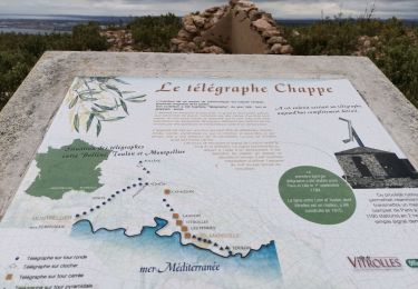
IGN / Geographical institutes

Download SityTrail from the App Store Download SityTrail from Google Play

Logo SityTrail SityTrail World

The world is yours!

Download SityTrail from the App Store Download SityTrail from Google Play Download SityTrail on Huawei AppGallery

About

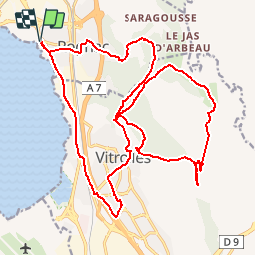
Trail Mountain bike of 28 km to be discovered at Provence-Alpes-Côte d'Azur, Bouches-du-Rhône, Rognac. This trail is proposed by tracegps.

Description

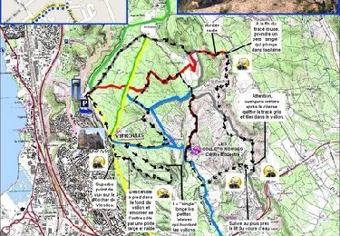
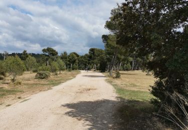
Sur le plateau de Vitrolles jusqu'au centre équestre Les Collets Rouges.

Elevation profile

Photos

Positioning

Country:
France
Region :
Provence-Alpes-Côte d'Azur
Department/Province :
Bouches-du-Rhône
Municipality :
Rognac
Location:
Unknown
Start:(UTM)
679501 ; 4817474 (31T) N.

Trails nearby

Trail Running Velaux - Aqueduc de Roquefavour - Velaux - Photo
Running
tracegps

Running

Medium
(2)
Velaux, Provence-Alpes-Côte d'Azur, Bouches-du-Rhône, France
12.4 km | 17.3 km-effort
1h 19min
Yes
Trail Mountain bike Vitrolles - Vitrolles - les Collets Rouges - Photo
Mountain bike
tracegps

Mountain bike

Medium
(1)
Vitrolles, Provence-Alpes-Côte d'Azur, Bouches-du-Rhône, France
23 km | 27 km-effort
3h 0min
Yes
Trail Walking Rognac - Vallon de Mion  - Photo
Walking
samifly51

Walking

Difficult
(1)
Rognac, Provence-Alpes-Côte d'Azur, Bouches-du-Rhône, France
11.3 km | 13.6 km-effort
1h 58min
Yes
Trail Walking Vitrolles - autour du Radar - Photo
Walking
samifly51

Walking

Medium
Vitrolles, Provence-Alpes-Côte d'Azur, Bouches-du-Rhône, France
7.9 km | 9.7 km-effort
1h 59min
Yes
Trail Walking Vitrolles - Plateau de Vitrolles-Tour du Pouchon - Photo
Walking
samifly51

Walking

Medium
Vitrolles, Provence-Alpes-Côte d'Azur, Bouches-du-Rhône, France
8.2 km | 9.8 km-effort
1h 53min
Yes
Trail Walking Vitrolles - plateau Vitrolles sud est - Photo
Walking
samifly51

Walking

Difficult
Vitrolles, Provence-Alpes-Côte d'Azur, Bouches-du-Rhône, France
12 km | 14.3 km-effort
2h 14min
Yes
Trail Walking Rognac - Tour du domaine de la Saragousse  - Photo
Walking
samifly51

Walking

Medium
Rognac, Provence-Alpes-Côte d'Azur, Bouches-du-Rhône, France
8.4 km | 10.5 km-effort
2h 26min
Yes
Trail Walking Vitrolles - les Crêtes de l'arbois  - Photo
Walking
samifly51

Walking

Difficult
Vitrolles, Provence-Alpes-Côte d'Azur, Bouches-du-Rhône, France
12.5 km | 14.8 km-effort
2h 56min
Yes
Trail Walking Velaux - velaux.jany - Photo
Walking
NADINE52

Walking

Very easy
Velaux, Provence-Alpes-Côte d'Azur, Bouches-du-Rhône, France
8.7 km | 11.4 km-effort
3h 31min
Yes


Close
My subscriptions