![](/images/other/stat-length.png)
![Trail Snowshoes Bareilles - Cirque de Bareilles en mars - Photo](https://media.geolcdn.com/t/1900/400/ext.pjpeg?maxdim=2&url=https%3A%2F%2Fstatic1.geolcdn.com%2Fsiteimages%2Fupload%2Ffiles%2F1524743153raquette.jpg)
Cirque de Bareilles en mars
dbellanger
User
![Length](/images/other/stat-length.png)
Length
17.6 km
![Max alt](https://static1.geolcdn.com/siteimages/upload/files/1508320355ic_sort_altitude_max_24dp.png)
Max alt
2144 m
![Uphill gradient](https://static1.geolcdn.com/siteimages/upload/files/1508320355ic_sort_den_pos_24dp.png)
Uphill gradient
1506 m
![Km-Effort](/images/other/stat-length.png)
Km-Effort
38 km
![Min alt](https://static1.geolcdn.com/siteimages/upload/files/1508320355ic_sort_altitude_min_24dp.png)
Min alt
1087 m
![Downhill gradient](https://static1.geolcdn.com/siteimages/upload/files/1508320355ic_sort_den_neg_24dp.png)
Downhill gradient
1567 m
![Boucle](https://static1.geolcdn.com/siteimages/upload/files/16400158638029165_repeat_loop_refresh_sync_direction_icon.png)
Boucle
No
Creation date :
2014-12-10 00:00:00.0
Updated on :
2014-12-10 00:00:00.0
![Snowshoes](https://static1.geolcdn.com/sitytour/trail-icons/504.png)
4h02
Difficulty : Medium
![Scan this QR Code to open this trail in the SityTrail application](https://capi.geolives.com/qq0zvz2zws4bq2lad0pu/sitytour/trails/116240/qr.png?size=200)
FREE GPS app for hiking
About
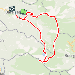
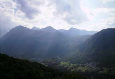
Trail Snowshoes of 17.6 km to be discovered at Occitania, Hautespyrenees, Bareilles. This trail is proposed by dbellanger.
Description
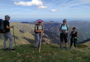
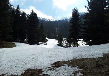
Très belle course faisable en raquettes ou ski de rando.
Il manque une petit partie de l'enregistrement mais qui est évidente entre les 2 premiers pics.
Positioning
Country:
France
Region :
Occitania
Department/Province :
Hautespyrenees
Municipality :
Bareilles
Location:
Unknown
Start:(Dec)
Start:(UTM)
290274 ; 4751910 (31T) N.
Comments
Trails nearby
![Trail Walking Bourg-d'Oueil - Sommet du Tech et Pic du Lion - Photo](https://media.geolcdn.com/t/375/260/ext.jpg?maxdim=2&url=https%3A%2F%2Fservices.sitytrail.com%2FGeolivesWS%2FDownloadMedia.ashx%3FTrailID%3D108803%26Media%3D2124_6.jpg)
![Walking Walking](https://static1.geolcdn.com/sitytour/trail-icons/101.png)
Sommet du Tech et Pic du Lion
Walking
Difficult
(1)
Bourg-d'Oueil,
Occitania,
Haute-Garonne,
France
![](/images/other/stat-length.png)
7.1 km | 13.3 km-effort
4h 4min
![](https://static1.geolcdn.com/siteimages/upload/files/16400158638029165_repeat_loop_refresh_sync_direction_icon.png)
Yes
![Trail Walking Ferrère - montagne d'Areng depuis la piste forestière après Férrères - Photo](https://media.geolcdn.com/t/375/260/b26d10b6-49f2-42a6-bd0e-42b976ea8679.jpg&format=jpg&maxdim=2)
![Walking Walking](https://static1.geolcdn.com/sitytour/trail-icons/101.png)
montagne d'Areng depuis la piste forestière après Férrères
Walking
Difficult
Ferrère,
Occitania,
Hautespyrenees,
France
![](/images/other/stat-length.png)
11.7 km | 24 km-effort
7h 44min
![](https://static1.geolcdn.com/siteimages/upload/files/16400158638029165_repeat_loop_refresh_sync_direction_icon.png)
Yes
![Trail On foot Bordères-Louron - Lac de Bareilles et Mont Né - Photo](https://media.geolcdn.com/t/375/260/7d524aea-9fca-43bb-898b-ff4e94703e2f.jpeg&format=jpg&maxdim=2)
![On foot On foot](https://static1.geolcdn.com/sitytour/trail-icons/100.png)
Lac de Bareilles et Mont Né
On foot
Easy
Bordères-Louron,
Occitania,
Hautespyrenees,
France
![](/images/other/stat-length.png)
3.8 km | 8.2 km-effort
1h 51min
![](https://static1.geolcdn.com/siteimages/upload/files/16400158638029165_repeat_loop_refresh_sync_direction_icon.png)
No
![Trail Walking Ferrère - Le Cournudère en boucle depuis Bordes de Saube - Photo](https://media.geolcdn.com/t/375/260/ext.jpg?maxdim=2&url=https%3A%2F%2Fservices.sitytrail.com%2FGeolivesWS%2FDownloadMedia.ashx%3FTrailID%3D754218%26Media%3Dfix__20170516124833.jpg)
![Walking Walking](https://static1.geolcdn.com/sitytour/trail-icons/101.png)
Le Cournudère en boucle depuis Bordes de Saube
Walking
Medium
Ferrère,
Occitania,
Hautespyrenees,
France
![](/images/other/stat-length.png)
17.2 km | 34 km-effort
6h 35min
![](https://static1.geolcdn.com/siteimages/upload/files/16400158638029165_repeat_loop_refresh_sync_direction_icon.png)
Yes
![Trail Walking Bareilles - Lac de Bareilles - Photo](https://media.geolcdn.com/t/375/260/ext.jpg?maxdim=2&url=https%3A%2F%2Fservices.sitytrail.com%2FGeolivesWS%2FDownloadMedia.ashx%3FTrailID%3D268170%26Media%3Dfix__20140419161621.jpg)
![Walking Walking](https://static1.geolcdn.com/sitytour/trail-icons/101.png)
Lac de Bareilles
Walking
Medium
Bareilles,
Occitania,
Hautespyrenees,
France
![](/images/other/stat-length.png)
13.4 km | 24 km-effort
7h 15min
![](https://static1.geolcdn.com/siteimages/upload/files/16400158638029165_repeat_loop_refresh_sync_direction_icon.png)
Yes
![Trail On foot Bourg-d'Oueil - Refuge du Mont Né - Photo](https://media.geolcdn.com/t/375/260/84c3e229-1989-4af4-b6f6-00591af5a1ff.jpeg&format=jpg&maxdim=2)
![On foot On foot](https://static1.geolcdn.com/sitytour/trail-icons/100.png)
Refuge du Mont Né
On foot
Easy
Bourg-d'Oueil,
Occitania,
Haute-Garonne,
France
![](/images/other/stat-length.png)
6.9 km | 12.7 km-effort
2h 53min
![](https://static1.geolcdn.com/siteimages/upload/files/16400158638029165_repeat_loop_refresh_sync_direction_icon.png)
No
![Trail Walking Bordères-Louron - Borderes-Louron <> Cazeaux - Photo](https://media.geolcdn.com/t/375/260/90e3d1ea-5bf2-4a9b-89ee-84ed0a38222d.jpg&format=jpg&maxdim=2)
![Walking Walking](https://static1.geolcdn.com/sitytour/trail-icons/101.png)
Borderes-Louron <> Cazeaux
Walking
Medium
Bordères-Louron,
Occitania,
Hautespyrenees,
France
![](/images/other/stat-length.png)
12.3 km | 21 km-effort
4h 9min
![](https://static1.geolcdn.com/siteimages/upload/files/16400158638029165_repeat_loop_refresh_sync_direction_icon.png)
Yes
![Trail Walking Ferrère - cap Nesté depuis la Barousse - Photo](https://media.geolcdn.com/t/375/260/ext.jpg?maxdim=2&url=https%3A%2F%2Fstatic1.geolcdn.com%2Fsiteimages%2Fupload%2Ffiles%2F1553511878bg_sport_marche.png)
![Walking Walking](https://static1.geolcdn.com/sitytour/trail-icons/101.png)
cap Nesté depuis la Barousse
Walking
Medium
Ferrère,
Occitania,
Hautespyrenees,
France
![](/images/other/stat-length.png)
9.2 km | 19.3 km-effort
6h 46min
![](https://static1.geolcdn.com/siteimages/upload/files/16400158638029165_repeat_loop_refresh_sync_direction_icon.png)
Yes
![Trail Walking Bordères-Louron - Bois de la Pale - Vallée du Louron - Photo](https://media.geolcdn.com/t/375/260/ext.jpg?maxdim=2&url=https%3A%2F%2Fservices.sitytrail.com%2FGeolivesWS%2FDownloadMedia.ashx%3FTrailID%3D102506%26Media%3D3315_1.jpg)
![Walking Walking](https://static1.geolcdn.com/sitytour/trail-icons/101.png)
Bois de la Pale - Vallée du Louron
Walking
Medium
Bordères-Louron,
Occitania,
Hautespyrenees,
France
![](/images/other/stat-length.png)
10 km | 18 km-effort
2h 30min
![](https://static1.geolcdn.com/siteimages/upload/files/16400158638029165_repeat_loop_refresh_sync_direction_icon.png)
Yes