![](/images/other/stat-length.png)
![Trail Walking Saint-Ouen-les-Vignes - Saint-Ouen-les-Vignes - Photo](https://media.geolcdn.com/t/1900/400/ext.pjpeg?maxdim=2&url=https%3A%2F%2Fstatic1.geolcdn.com%2Fsiteimages%2Fupload%2Ffiles%2F1553511878bg_sport_marche.png)
Saint-Ouen-les-Vignes
LEMENIO
User
![Length](/images/other/stat-length.png)
Length
8.3 km
![Max alt](https://static1.geolcdn.com/siteimages/upload/files/1508320355ic_sort_altitude_max_24dp.png)
Max alt
113 m
![Uphill gradient](https://static1.geolcdn.com/siteimages/upload/files/1508320355ic_sort_den_pos_24dp.png)
Uphill gradient
118 m
![Km-Effort](/images/other/stat-length.png)
Km-Effort
9.9 km
![Min alt](https://static1.geolcdn.com/siteimages/upload/files/1508320355ic_sort_altitude_min_24dp.png)
Min alt
68 m
![Downhill gradient](https://static1.geolcdn.com/siteimages/upload/files/1508320355ic_sort_den_neg_24dp.png)
Downhill gradient
118 m
![Boucle](https://static1.geolcdn.com/siteimages/upload/files/16400158638029165_repeat_loop_refresh_sync_direction_icon.png)
Boucle
Yes
Creation date :
2014-12-10 00:00:00.0
Updated on :
2014-12-10 00:00:00.0
![Walking](https://static1.geolcdn.com/sitytour/trail-icons/101.png)
2h30
Difficulty : Easy
![Scan this QR Code to open this trail in the SityTrail application](https://capi.geolives.com/qq0zvz2zws4bq2lad0pu/sitytour/trails/115515/qr.png?size=200)
FREE GPS app for hiking
About
Trail Walking of 8.3 km to be discovered at Centre-Loire Valley, Indre-et-Loire, Saint-Ouen-les-Vignes. This trail is proposed by LEMENIO.
Description
Départ Place de l'église jusqu'au lieu-dit "la Longueterie". Faire la boucle et retour par le même chemin qu'à l'aller à partir de "la Longueterie".
Positioning
Country:
France
Region :
Centre-Loire Valley
Department/Province :
Indre-et-Loire
Municipality :
Saint-Ouen-les-Vignes
Location:
Unknown
Start:(Dec)
Start:(UTM)
348860 ; 5259076 (31T) N.
Comments
Trails nearby
![Trail Walking Pocé-sur-Cisse - Pocé-sur-Cisse - Saint-Ouen-les-Vignes - 17km 305m 3h45 (35mn) - 2024 04 10 - Photo](https://media.geolcdn.com/t/375/260/40530b85-1831-4d54-bee3-88999e7b680f.jpg&format=jpg&maxdim=2)
![Walking Walking](https://static1.geolcdn.com/sitytour/trail-icons/101.png)
Pocé-sur-Cisse - Saint-Ouen-les-Vignes - 17km 305m 3h45 (35mn) - 2024 04 10
Walking
Medium
Pocé-sur-Cisse,
Centre-Loire Valley,
Indre-et-Loire,
France
![](/images/other/stat-length.png)
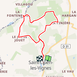
17.1 km | 21 km-effort
3h 45min
![](https://static1.geolcdn.com/siteimages/upload/files/16400158638029165_repeat_loop_refresh_sync_direction_icon.png)
Yes
![Trail Walking Nazelles-Négron - Nazelles-Négron - Zig zag autour de Nazelles et de Pocé-sur-Cisse - 18.1km 340m 4h05 - 2024 03 24 - Photo](https://media.geolcdn.com/t/375/260/b4c80bca-e974-478d-aff9-0771f417e572.jpg&format=jpg&maxdim=2)
![Walking Walking](https://static1.geolcdn.com/sitytour/trail-icons/101.png)
Nazelles-Négron - Zig zag autour de Nazelles et de Pocé-sur-Cisse - 18.1km 34...
Walking
Medium
Nazelles-Négron,
Centre-Loire Valley,
Indre-et-Loire,
France
![](/images/other/stat-length.png)
18.1 km | 23 km-effort
4h 5min
![](https://static1.geolcdn.com/siteimages/upload/files/16400158638029165_repeat_loop_refresh_sync_direction_icon.png)
Yes
![Trail Walking Nazelles-Négron - Nazelles-Négron - variante PR Circuit Val Plateau - 10.6km 125m 2h25 (40mn) - 2023 12 20 - Photo](https://media.geolcdn.com/t/375/260/db197c9d-ca81-4840-908b-9a2fe7566a1d.jpg&format=jpg&maxdim=2)
![Walking Walking](https://static1.geolcdn.com/sitytour/trail-icons/101.png)
Nazelles-Négron - variante PR Circuit Val Plateau - 10.6km 125m 2h25 (40mn) -...
Walking
Easy
Nazelles-Négron,
Centre-Loire Valley,
Indre-et-Loire,
France
![](/images/other/stat-length.png)
10.6 km | 12.3 km-effort
2h 25min
![](https://static1.geolcdn.com/siteimages/upload/files/16400158638029165_repeat_loop_refresh_sync_direction_icon.png)
Yes
![Trail Walking Limeray - Limeray - Sentier des terroirs - 14.2km 115m 3h25 - 2023 06 25 - Photo](https://media.geolcdn.com/t/375/260/27e57aa7-96fe-4442-8b9b-71dd321d3126.jpg&format=jpg&maxdim=2)
![Walking Walking](https://static1.geolcdn.com/sitytour/trail-icons/101.png)
Limeray - Sentier des terroirs - 14.2km 115m 3h25 - 2023 06 25
Walking
Easy
Limeray,
Centre-Loire Valley,
Indre-et-Loire,
France
![](/images/other/stat-length.png)
14.2 km | 15.7 km-effort
3h 25min
![](https://static1.geolcdn.com/siteimages/upload/files/16400158638029165_repeat_loop_refresh_sync_direction_icon.png)
Yes
![Trail Walking Cangey - Cangey - GR3 Limeray - 10.6km 100m 2h25 (30mn) - 2023 06 25 - Photo](https://media.geolcdn.com/t/375/260/594ca9d8-e234-4a82-a4b0-e2cbad9ae9af.jpg&format=jpg&maxdim=2)
![Walking Walking](https://static1.geolcdn.com/sitytour/trail-icons/101.png)
Cangey - GR3 Limeray - 10.6km 100m 2h25 (30mn) - 2023 06 25
Walking
Medium
Cangey,
Centre-Loire Valley,
Indre-et-Loire,
France
![](/images/other/stat-length.png)
10.6 km | 12 km-effort
2h 43min
![](https://static1.geolcdn.com/siteimages/upload/files/16400158638029165_repeat_loop_refresh_sync_direction_icon.png)
Yes
![Trail Walking Montreuil-en-Touraine - Montreuil-en-Touraine - 11.7km 80m 2h55 (25mn) - 2023 06 11 - Photo](https://media.geolcdn.com/t/375/260/0189885a-cd86-4745-9ccb-6a513f3d040b.jpg&format=jpg&maxdim=2)
![Walking Walking](https://static1.geolcdn.com/sitytour/trail-icons/101.png)
Montreuil-en-Touraine - 11.7km 80m 2h55 (25mn) - 2023 06 11
Walking
Easy
Montreuil-en-Touraine,
Centre-Loire Valley,
Indre-et-Loire,
France
![](/images/other/stat-length.png)
11.7 km | 12.7 km-effort
2h 55min
![](https://static1.geolcdn.com/siteimages/upload/files/16400158638029165_repeat_loop_refresh_sync_direction_icon.png)
Yes
![Trail Walking Saint-Ouen-les-Vignes - Saint-Ouen-les-Vignes - Pocé-sur-Cisse 460 - 23.9km 460m 5h40 - 2022 05 29 - Photo](https://media.geolcdn.com/t/375/260/b0c4ad32-f026-4444-8017-61bcacea1ca2.jpg&format=jpg&maxdim=2)
![Walking Walking](https://static1.geolcdn.com/sitytour/trail-icons/101.png)
Saint-Ouen-les-Vignes - Pocé-sur-Cisse 460 - 23.9km 460m 5h40 - 2022 05 29
Walking
Medium
Saint-Ouen-les-Vignes,
Centre-Loire Valley,
Indre-et-Loire,
France
![](/images/other/stat-length.png)
24 km | 30 km-effort
5h 40min
![](https://static1.geolcdn.com/siteimages/upload/files/16400158638029165_repeat_loop_refresh_sync_direction_icon.png)
Yes
![Walking Walking](https://static1.geolcdn.com/sitytour/trail-icons/101.png)
Pocé-sur-Cisse - Sentier des 3 Vallées - 14.9km 225m 3h25 - 2022 03 26
Walking
Medium
Pocé-sur-Cisse,
Centre-Loire Valley,
Indre-et-Loire,
France
![](/images/other/stat-length.png)
14.9 km | 17.9 km-effort
3h 25min
![](https://static1.geolcdn.com/siteimages/upload/files/16400158638029165_repeat_loop_refresh_sync_direction_icon.png)
Yes
![Trail Walking Nazelles-Négron - Nazelles-Négron - Circuit Val Vallées avec variantes - 16.2km 215m 3h35 - 2022 03 20 - Photo](https://media.geolcdn.com/t/375/260/d7269374-9ddb-4ef6-b612-9579ef8c2ac3.jpg&format=jpg&maxdim=2)
![Walking Walking](https://static1.geolcdn.com/sitytour/trail-icons/101.png)
Nazelles-Négron - Circuit Val Vallées avec variantes - 16.2km 215m 3h35 - 202...
Walking
Easy
Nazelles-Négron,
Centre-Loire Valley,
Indre-et-Loire,
France
![](/images/other/stat-length.png)
16.2 km | 19.1 km-effort
3h 35min
![](https://static1.geolcdn.com/siteimages/upload/files/16400158638029165_repeat_loop_refresh_sync_direction_icon.png)
Yes