![](/images/other/stat-length.png)
![Trail Walking Signes - Signes - Siou Blanc - Le Grand CAP - Photo](https://media.geolcdn.com/t/1900/400/ext.pjpeg?maxdim=2&url=https%3A%2F%2Fstatic1.geolcdn.com%2Fsiteimages%2Fupload%2Ffiles%2F1553511878bg_sport_marche.png)
Signes - Siou Blanc - Le Grand CAP
pourrier
User
![Length](/images/other/stat-length.png)
Length
15.7 km
![Max alt](https://static1.geolcdn.com/siteimages/upload/files/1508320355ic_sort_altitude_max_24dp.png)
Max alt
780 m
![Uphill gradient](https://static1.geolcdn.com/siteimages/upload/files/1508320355ic_sort_den_pos_24dp.png)
Uphill gradient
429 m
![Km-Effort](/images/other/stat-length.png)
Km-Effort
21 km
![Min alt](https://static1.geolcdn.com/siteimages/upload/files/1508320355ic_sort_altitude_min_24dp.png)
Min alt
510 m
![Downhill gradient](https://static1.geolcdn.com/siteimages/upload/files/1508320355ic_sort_den_neg_24dp.png)
Downhill gradient
429 m
![Boucle](https://static1.geolcdn.com/siteimages/upload/files/16400158638029165_repeat_loop_refresh_sync_direction_icon.png)
Boucle
Yes
Creation date :
2018-10-09 15:43:45.584
Updated on :
2018-10-09 15:43:45.668
![Walking](https://static1.geolcdn.com/sitytour/trail-icons/101.png)
5h34
Difficulty : Easy
![Scan this QR Code to open this trail in the SityTrail application](https://capi.geolives.com/qq0zvz2zws4bq2lad0pu/sitytour/trails/115408/qr.png?size=200)
FREE GPS app for hiking
About
Trail Walking of 15.7 km to be discovered at Provence-Alpes-Côte d'Azur, Var, Signes. This trail is proposed by pourrier.
Description
Siou Blanc - Le Grand CAP Promenade sans difficulté.
Pour la descente du Grand CAP, pour éviter la descente raide, on peut prendre le sentier plus long.
Positioning
Country:
France
Region :
Provence-Alpes-Côte d'Azur
Department/Province :
Var
Municipality :
Signes
Location:
Unknown
Start:(Dec)
Start:(UTM)
737282 ; 4790160 (31T) N.
Comments
Trails nearby
![Trail Walking Solliès-Toucas - Morières : la Garoute et la Baume des Lumes - Photo](https://media.geolcdn.com/t/375/260/3e6ddcf9-f59d-47f4-a0ee-582c12a1d8d8.jpg&format=jpg&maxdim=2)
![Walking Walking](https://static1.geolcdn.com/sitytour/trail-icons/101.png)
Morières : la Garoute et la Baume des Lumes
Walking
Easy
(1)
Solliès-Toucas,
Provence-Alpes-Côte d'Azur,
Var,
France
![](/images/other/stat-length.png)
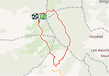
12.6 km | 16.7 km-effort
6h 0min
![](https://static1.geolcdn.com/siteimages/upload/files/16400158638029165_repeat_loop_refresh_sync_direction_icon.png)
Yes
![Trail Walking Solliès-Toucas - SityTrail - siou blanc - Photo](https://media.geolcdn.com/t/375/260/2137f2fb-f7c1-49df-9712-76654d4b67c0.jpg&format=jpg&maxdim=2)
![Walking Walking](https://static1.geolcdn.com/sitytour/trail-icons/101.png)
SityTrail - siou blanc
Walking
Medium
(1)
Solliès-Toucas,
Provence-Alpes-Côte d'Azur,
Var,
France
![](/images/other/stat-length.png)
12.5 km | 17.4 km-effort
6h 0min
![](https://static1.geolcdn.com/siteimages/upload/files/16400158638029165_repeat_loop_refresh_sync_direction_icon.png)
Yes
![Trail Walking Méounes-lès-Montrieux - SityTrail - montrieux gapeau - Photo](https://media.geolcdn.com/t/375/260/864c4f64-6bc1-49cf-aec6-4e1027a495ef.jpg&format=jpg&maxdim=2)
![Walking Walking](https://static1.geolcdn.com/sitytour/trail-icons/101.png)
SityTrail - montrieux gapeau
Walking
Very difficult
(2)
Méounes-lès-Montrieux,
Provence-Alpes-Côte d'Azur,
Var,
France
![](/images/other/stat-length.png)
15.9 km | 23 km-effort
5h 14min
![](https://static1.geolcdn.com/siteimages/upload/files/16400158638029165_repeat_loop_refresh_sync_direction_icon.png)
Yes
![Trail Walking Méounes-lès-Montrieux - Chartreuse de Montreuil le jeune - Photo](https://media.geolcdn.com/t/375/260/ext.jpg?maxdim=2&url=https%3A%2F%2Fservices.sitytrail.com%2FGeolivesWS%2FDownloadMedia.ashx%3FTrailID%3D627194%26Media%3Dfix__20160906115209.jpg)
![Walking Walking](https://static1.geolcdn.com/sitytour/trail-icons/101.png)
Chartreuse de Montreuil le jeune
Walking
Easy
(1)
Méounes-lès-Montrieux,
Provence-Alpes-Côte d'Azur,
Var,
France
![](/images/other/stat-length.png)
11.9 km | 17.1 km-effort
5h 10min
![](https://static1.geolcdn.com/siteimages/upload/files/16400158638029165_repeat_loop_refresh_sync_direction_icon.png)
Yes
![Trail Walking Le Revest-les-Eaux - Stade du Revest - Turcos - Cassini - Retour - Photo](https://media.geolcdn.com/t/375/260/fa3a56ef-9278-48c7-a87d-33f7986baed3.jpg&format=jpg&maxdim=2)
![Walking Walking](https://static1.geolcdn.com/sitytour/trail-icons/101.png)
Stade du Revest - Turcos - Cassini - Retour
Walking
Medium
Le Revest-les-Eaux,
Provence-Alpes-Côte d'Azur,
Var,
France
![](/images/other/stat-length.png)
11.4 km | 18.2 km-effort
4h 0min
![](https://static1.geolcdn.com/siteimages/upload/files/16400158638029165_repeat_loop_refresh_sync_direction_icon.png)
Yes
![Trail Walking Solliès-Toucas - Sioux Blanc le cou de la Marquise - Photo](https://media.geolcdn.com/t/375/260/ext.jpg?maxdim=2&url=https%3A%2F%2Fservices.sitytrail.com%2FGeolivesWS%2FDownloadMedia.ashx%3FTrailID%3D875650%26Media%3Dfix__20171214134620.jpg)
![Walking Walking](https://static1.geolcdn.com/sitytour/trail-icons/101.png)
Sioux Blanc le cou de la Marquise
Walking
Easy
(1)
Solliès-Toucas,
Provence-Alpes-Côte d'Azur,
Var,
France
![](/images/other/stat-length.png)
9.4 km | 12.6 km-effort
5h 5min
![](https://static1.geolcdn.com/siteimages/upload/files/16400158638029165_repeat_loop_refresh_sync_direction_icon.png)
Yes
![Trail Running Signes - PLATEAU DE SIOUX BLANC - LES AIGUILLES DE VALBELLE - 10KM - Photo](https://media.geolcdn.com/t/375/260/ext.jpg?maxdim=2&url=https%3A%2F%2Fstatic1.geolcdn.com%2Fsiteimages%2Fupload%2Ffiles%2F1524743154running.jpg)
![Running Running](https://static1.geolcdn.com/sitytour/trail-icons/103.png)
PLATEAU DE SIOUX BLANC - LES AIGUILLES DE VALBELLE - 10KM
Running
Medium
(2)
Signes,
Provence-Alpes-Côte d'Azur,
Var,
France
![](/images/other/stat-length.png)
9.9 km | 13.4 km-effort
1h 45min
![](https://static1.geolcdn.com/siteimages/upload/files/16400158638029165_repeat_loop_refresh_sync_direction_icon.png)
Yes
![Trail Other activity Signes - Plateau de Siou Blanc 1 - Photo](https://media.geolcdn.com/t/375/260/ext.jpg?maxdim=2&url=https%3A%2F%2Fstatic1.geolcdn.com%2Fsiteimages%2Fupload%2Ffiles%2F1545311037marcheuse_200dpi.jpg)
![Other activity Other activity](https://static1.geolcdn.com/sitytour/trail-icons/900.png)
Plateau de Siou Blanc 1
Other activity
Very easy
(1)
Signes,
Provence-Alpes-Côte d'Azur,
Var,
France
![](/images/other/stat-length.png)
3.2 km | 3.8 km-effort
1h 0min
![](https://static1.geolcdn.com/siteimages/upload/files/16400158638029165_repeat_loop_refresh_sync_direction_icon.png)
Yes
![Trail Walking Méounes-lès-Montrieux - Chartreuse de Montrieux, lac et vallée du Gapeau - Photo](https://media.geolcdn.com/t/375/260/50a94807-a6ea-450b-97b3-59dee71f4fef.jpg&format=jpg&maxdim=2)
![Walking Walking](https://static1.geolcdn.com/sitytour/trail-icons/101.png)
Chartreuse de Montrieux, lac et vallée du Gapeau
Walking
Medium
Méounes-lès-Montrieux,
Provence-Alpes-Côte d'Azur,
Var,
France
![](/images/other/stat-length.png)
14.3 km | 18.3 km-effort
4h 9min
![](https://static1.geolcdn.com/siteimages/upload/files/16400158638029165_repeat_loop_refresh_sync_direction_icon.png)
Yes