![](/images/other/stat-length.png)
![Trail Mountain bike Massy - Petit tour du bois de Verrière - Photo](https://media.geolcdn.com/t/1900/400/ext.pjpeg?maxdim=2&url=https%3A%2F%2Fstatic1.geolcdn.com%2Fsiteimages%2Fupload%2Ffiles%2F1524743154velo.jpg)
Petit tour du bois de Verrière
laniole
User
![Length](/images/other/stat-length.png)
Length
17.4 km
![Max alt](https://static1.geolcdn.com/siteimages/upload/files/1508320355ic_sort_altitude_max_24dp.png)
Max alt
180 m
![Uphill gradient](https://static1.geolcdn.com/siteimages/upload/files/1508320355ic_sort_den_pos_24dp.png)
Uphill gradient
238 m
![Km-Effort](/images/other/stat-length.png)
Km-Effort
21 km
![Min alt](https://static1.geolcdn.com/siteimages/upload/files/1508320355ic_sort_altitude_min_24dp.png)
Min alt
55 m
![Downhill gradient](https://static1.geolcdn.com/siteimages/upload/files/1508320355ic_sort_den_neg_24dp.png)
Downhill gradient
238 m
![Boucle](https://static1.geolcdn.com/siteimages/upload/files/16400158638029165_repeat_loop_refresh_sync_direction_icon.png)
Boucle
Yes
Creation date :
2014-12-10 00:00:00.0
Updated on :
2014-12-10 00:00:00.0
![Mountain bike](https://static1.geolcdn.com/sitytour/trail-icons/202.png)
--
Difficulty : Very easy
![Scan this QR Code to open this trail in the SityTrail application](https://capi.geolives.com/qq0zvz2zws4bq2lad0pu/sitytour/trails/115103/qr.png?size=200)
FREE GPS app for hiking
About
Trail Mountain bike of 17.4 km to be discovered at Ile-de-France, Essonne, Massy. This trail is proposed by laniole.
Description
Départ: place de l'Union Européenne, Massy
Parcours réalisé dans le sens anti-horaire.
Durée: 1h (niveau débutant)
Pour un bon VTTiste je pense que c'est réalisable en 40-45min.
Positioning
Country:
France
Region :
Ile-de-France
Department/Province :
Essonne
Municipality :
Massy
Location:
Unknown
Start:(Dec)
Start:(UTM)
445420 ; 5397394 (31U) N.
Comments
Trails nearby
![Trail Walking Bièvres - De Bièvres à Antony - Photo](https://media.geolcdn.com/t/375/260/ext.jpg?maxdim=2&url=https%3A%2F%2Fservices.sitytrail.com%2FGeolivesWS%2FDownloadMedia.ashx%3FTrailID%3D106789%26Media%3D11480_3.jpg)
![Walking Walking](https://static1.geolcdn.com/sitytour/trail-icons/101.png)
De Bièvres à Antony
Walking
Medium
(1)
Bièvres,
Ile-de-France,
Essonne,
France
![](/images/other/stat-length.png)
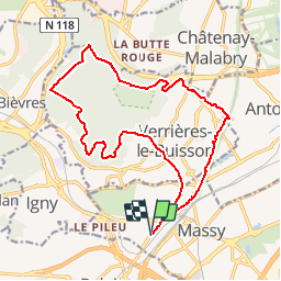
11.9 km | 14 km-effort
3h 0min
![](https://static1.geolcdn.com/siteimages/upload/files/16400158638029165_repeat_loop_refresh_sync_direction_icon.png)
No
![Trail Walking Palaiseau - De Lozere à Gif sur Yvette - Photo](https://media.geolcdn.com/t/375/260/ext.jpg?maxdim=2&url=https%3A%2F%2Fservices.sitytrail.com%2FGeolivesWS%2FDownloadMedia.ashx%3FTrailID%3D106655%26Media%3D11272_3.jpg)
![Walking Walking](https://static1.geolcdn.com/sitytour/trail-icons/101.png)
De Lozere à Gif sur Yvette
Walking
Medium
(1)
Palaiseau,
Ile-de-France,
Essonne,
France
![](/images/other/stat-length.png)
21 km | 28 km-effort
5h 0min
![](https://static1.geolcdn.com/siteimages/upload/files/16400158638029165_repeat_loop_refresh_sync_direction_icon.png)
Yes
![Trail Walking Verrières-le-Buisson - Sur les sentiers de découverte du Bois de Verrières - Photo](https://media.geolcdn.com/t/375/260/ext.jpg?maxdim=2&url=https%3A%2F%2Fservices.sitytrail.com%2FGeolivesWS%2FDownloadMedia.ashx%3FTrailID%3D110232%26Media%3D5500_1.jpg)
![Walking Walking](https://static1.geolcdn.com/sitytour/trail-icons/101.png)
Sur les sentiers de découverte du Bois de Verrières
Walking
Medium
(2)
Verrières-le-Buisson,
Ile-de-France,
Essonne,
France
![](/images/other/stat-length.png)
22 km | 27 km-effort
4h 40min
![](https://static1.geolcdn.com/siteimages/upload/files/16400158638029165_repeat_loop_refresh_sync_direction_icon.png)
Yes
![Trail Walking Bièvres - Autour de Bièvres - Photo](https://media.geolcdn.com/t/375/260/ext.jpg?maxdim=2&url=https%3A%2F%2Fservices.sitytrail.com%2FGeolivesWS%2FDownloadMedia.ashx%3FTrailID%3D102999%26Media%3D4541_2.jpg)
![Walking Walking](https://static1.geolcdn.com/sitytour/trail-icons/101.png)
Autour de Bièvres
Walking
Medium
(4)
Bièvres,
Ile-de-France,
Essonne,
France
![](/images/other/stat-length.png)
7.6 km | 9.4 km-effort
2h 30min
![](https://static1.geolcdn.com/siteimages/upload/files/16400158638029165_repeat_loop_refresh_sync_direction_icon.png)
Yes
![Trail Walking Igny - tour du plateau de Saclay V2 - Photo](https://media.geolcdn.com/t/375/260/ext.jpg?maxdim=2&url=https%3A%2F%2Fstatic1.geolcdn.com%2Fsiteimages%2Fupload%2Ffiles%2F1553511878bg_sport_marche.png)
![Walking Walking](https://static1.geolcdn.com/sitytour/trail-icons/101.png)
tour du plateau de Saclay V2
Walking
Very difficult
(1)
Igny,
Ile-de-France,
Essonne,
France
![](/images/other/stat-length.png)
21 km | 25 km-effort
5h 36min
![](https://static1.geolcdn.com/siteimages/upload/files/16400158638029165_repeat_loop_refresh_sync_direction_icon.png)
Yes
![Trail Walking Longjumeau - Boucle 23 km autour de Longjumeau - Photo](https://media.geolcdn.com/t/375/260/a98102b6-d183-4b5b-8bb0-fb39230ce35c.jpg&format=jpg&maxdim=2)
![Walking Walking](https://static1.geolcdn.com/sitytour/trail-icons/101.png)
Boucle 23 km autour de Longjumeau
Walking
Medium
Longjumeau,
Ile-de-France,
Essonne,
France
![](/images/other/stat-length.png)
23 km | 27 km-effort
4h 48min
![](https://static1.geolcdn.com/siteimages/upload/files/16400158638029165_repeat_loop_refresh_sync_direction_icon.png)
Yes
![Trail Walking Sceaux - Boucle autour du parc de Sceaux - Photo](https://media.geolcdn.com/t/375/260/a68a703b-59c1-496c-bcd2-be669bbe22a1.jpg&format=jpg&maxdim=2)
![Walking Walking](https://static1.geolcdn.com/sitytour/trail-icons/101.png)
Boucle autour du parc de Sceaux
Walking
Very easy
Sceaux,
Ile-de-France,
Hauts-de-Seine,
France
![](/images/other/stat-length.png)
19 km | 23 km-effort
4h 24min
![](https://static1.geolcdn.com/siteimages/upload/files/16400158638029165_repeat_loop_refresh_sync_direction_icon.png)
Yes
![Trail Walking Verrières-le-Buisson - Boucle autour de Verrières le Buisson - Photo](https://media.geolcdn.com/t/375/260/e3400994-d836-42da-a137-76fd998d9849.jpg&format=jpg&maxdim=2)
![Walking Walking](https://static1.geolcdn.com/sitytour/trail-icons/101.png)
Boucle autour de Verrières le Buisson
Walking
Medium
Verrières-le-Buisson,
Ile-de-France,
Essonne,
France
![](/images/other/stat-length.png)
25 km | 31 km-effort
5h 22min
![](https://static1.geolcdn.com/siteimages/upload/files/16400158638029165_repeat_loop_refresh_sync_direction_icon.png)
Yes
![Trail Walking Antony - Boucle Antony - Chatenay - Igny - Bièvres - Photo](https://media.geolcdn.com/t/375/260/26d35776-e0b1-40e5-952d-c653b146e131.jpg&format=jpg&maxdim=2)
![Walking Walking](https://static1.geolcdn.com/sitytour/trail-icons/101.png)
Boucle Antony - Chatenay - Igny - Bièvres
Walking
Easy
Antony,
Ile-de-France,
Hauts-de-Seine,
France
![](/images/other/stat-length.png)
24 km | 30 km-effort
5h 31min
![](https://static1.geolcdn.com/siteimages/upload/files/16400158638029165_repeat_loop_refresh_sync_direction_icon.png)
Yes