![](/images/other/stat-length.png)
![Trail Walking Fontainebleau - 2012-02-28 Rocher Cuvier - Photo](https://media.geolcdn.com/t/1900/400/ext.pjpeg?maxdim=2&url=https%3A%2F%2Fservices.sitytrail.com%2FGeolivesWS%2FDownloadMedia.ashx%3FTrailID%3D114727%26Media%3D20120228113643.jpeg)
2012-02-28 Rocher Cuvier
TaxiMarne
User
![Length](/images/other/stat-length.png)
Length
12.6 km
![Max alt](https://static1.geolcdn.com/siteimages/upload/files/1508320355ic_sort_altitude_max_24dp.png)
Max alt
150 m
![Uphill gradient](https://static1.geolcdn.com/siteimages/upload/files/1508320355ic_sort_den_pos_24dp.png)
Uphill gradient
246 m
![Km-Effort](/images/other/stat-length.png)
Km-Effort
15.8 km
![Min alt](https://static1.geolcdn.com/siteimages/upload/files/1508320355ic_sort_altitude_min_24dp.png)
Min alt
87 m
![Downhill gradient](https://static1.geolcdn.com/siteimages/upload/files/1508320355ic_sort_den_neg_24dp.png)
Downhill gradient
247 m
![Boucle](https://static1.geolcdn.com/siteimages/upload/files/16400158638029165_repeat_loop_refresh_sync_direction_icon.png)
Boucle
Yes
Creation date :
2014-12-10 00:00:00.0
Updated on :
2014-12-10 00:00:00.0
![Walking](https://static1.geolcdn.com/sitytour/trail-icons/101.png)
6h00
Difficulty : Medium
![Scan this QR Code to open this trail in the SityTrail application](https://capi.geolives.com/qq0zvz2zws4bq2lad0pu/sitytour/trails/114727/qr.png?size=200)
FREE GPS app for hiking
About
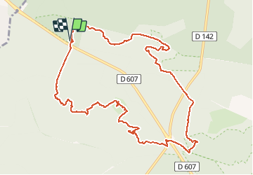
Trail Walking of 12.6 km to be discovered at Ile-de-France, Seine-et-Marne, Fontainebleau. This trail is proposed by TaxiMarne.
Description
Départ du Carrefour de l'épine traversée du rocher cuvier chatillon par le GR1, passage sur les hauteurs de la Solle, traversée de la N7 au carrefour du Grand veneur, passage dans le désert d'Apremont et retour par la route de la solitude.
Points of interest
Positioning
Country:
France
Region :
Ile-de-France
Department/Province :
Seine-et-Marne
Municipality :
Fontainebleau
Location:
Unknown
Start:(Dec)
Start:(UTM)
473168 ; 5365977 (31U) N.
Comments
Trails nearby
![Trail Walking Barbizon - Sentier des peintres - Photo](https://media.geolcdn.com/t/375/260/ext.jpg?maxdim=2&url=https%3A%2F%2Fservices.sitytrail.com%2FGeolivesWS%2FDownloadMedia.ashx%3FTrailID%3D188736%26Media%3D187396bd-9ee4-4169-9310-5793d2588587.jpeg)
![Walking Walking](https://static1.geolcdn.com/sitytour/trail-icons/101.png)
Sentier des peintres
Walking
Medium
(11)
Barbizon,
Ile-de-France,
Seine-et-Marne,
France
![](/images/other/stat-length.png)
7.5 km | 8.2 km-effort
1h 25min
![](https://static1.geolcdn.com/siteimages/upload/files/16400158638029165_repeat_loop_refresh_sync_direction_icon.png)
Yes
![Trail Walking Fontainebleau - Sur les traces de Césaire Sempité - Fontainebleau rocher canon - Photo](https://media.geolcdn.com/t/375/260/b9aa5b48-fd03-4263-8213-67fa0706433b.jpg&format=jpg&maxdim=2)
![Walking Walking](https://static1.geolcdn.com/sitytour/trail-icons/101.png)
Sur les traces de Césaire Sempité - Fontainebleau rocher canon
Walking
Easy
(1)
Fontainebleau,
Ile-de-France,
Seine-et-Marne,
France
![](/images/other/stat-length.png)
17.3 km | 21 km-effort
4h 8min
![](https://static1.geolcdn.com/siteimages/upload/files/16400158638029165_repeat_loop_refresh_sync_direction_icon.png)
Yes
![Trail Walking Fontainebleau - 3pi-150428 - DésertApremont-Jupiter - Photo](https://media.geolcdn.com/t/375/260/ext.jpg?maxdim=2&url=https%3A%2F%2Fservices.sitytrail.com%2FGeolivesWS%2FDownloadMedia.ashx%3FTrailID%3D414037%26Media%3D22942274-9308-46bb-bc6d-06c82c3e8751.jpg)
![Walking Walking](https://static1.geolcdn.com/sitytour/trail-icons/101.png)
3pi-150428 - DésertApremont-Jupiter
Walking
Easy
(1)
Fontainebleau,
Ile-de-France,
Seine-et-Marne,
France
![](/images/other/stat-length.png)
16 km | 19.4 km-effort
6h 30min
![](https://static1.geolcdn.com/siteimages/upload/files/16400158638029165_repeat_loop_refresh_sync_direction_icon.png)
Yes
![Trail Walking Fontainebleau - Boucle Barbizon - Arbonne 26 km - Photo](https://media.geolcdn.com/t/375/260/d3a133ff-ea77-47a6-826a-54bbe45391c4.jpg&format=jpg&maxdim=2)
![Walking Walking](https://static1.geolcdn.com/sitytour/trail-icons/101.png)
Boucle Barbizon - Arbonne 26 km
Walking
Medium
Fontainebleau,
Ile-de-France,
Seine-et-Marne,
France
![](/images/other/stat-length.png)
26 km | 30 km-effort
5h 6min
![](https://static1.geolcdn.com/siteimages/upload/files/16400158638029165_repeat_loop_refresh_sync_direction_icon.png)
Yes
![Trail On foot Fontainebleau - Fontainebleau les monts de Fay - Photo](https://media.geolcdn.com/t/375/260/44c84e7a-206d-494a-bf60-bcd1709cbc23.jpg&format=jpg&maxdim=2)
![On foot On foot](https://static1.geolcdn.com/sitytour/trail-icons/100.png)
Fontainebleau les monts de Fay
On foot
Medium
Fontainebleau,
Ile-de-France,
Seine-et-Marne,
France
![](/images/other/stat-length.png)
22 km | 27 km-effort
6h 12min
![](https://static1.geolcdn.com/siteimages/upload/files/16400158638029165_repeat_loop_refresh_sync_direction_icon.png)
Yes
![Trail Walking Fontainebleau - SityTrail - JC 71 Fontainebleau Rocher Cassepot, Tour Denecourt - Photo](https://media.geolcdn.com/t/375/260/ext.jpg?maxdim=2&url=https%3A%2F%2Fstatic1.geolcdn.com%2Fsiteimages%2Fupload%2Ffiles%2F1553511878bg_sport_marche.png)
![Walking Walking](https://static1.geolcdn.com/sitytour/trail-icons/101.png)
SityTrail - JC 71 Fontainebleau Rocher Cassepot, Tour Denecourt
Walking
Difficult
(1)
Fontainebleau,
Ile-de-France,
Seine-et-Marne,
France
![](/images/other/stat-length.png)
16.9 km | 22 km-effort
4h 55min
![](https://static1.geolcdn.com/siteimages/upload/files/16400158638029165_repeat_loop_refresh_sync_direction_icon.png)
Yes
![Trail On foot Fontainebleau - Rando des trois châteaux parcours 42 km Fontainebleau Vaux le vicomte Blandy les tours - Photo](https://media.geolcdn.com/t/375/260/d6540ba5-9e95-4c55-9c15-89101ab2c33e.jpg&format=jpg&maxdim=2)
![On foot On foot](https://static1.geolcdn.com/sitytour/trail-icons/100.png)
Rando des trois châteaux parcours 42 km Fontainebleau Vaux le vicomte Blandy ...
On foot
Very difficult
Fontainebleau,
Ile-de-France,
Seine-et-Marne,
France
![](/images/other/stat-length.png)
43 km | 50 km-effort
11h 23min
![](https://static1.geolcdn.com/siteimages/upload/files/16400158638029165_repeat_loop_refresh_sync_direction_icon.png)
No
![Trail Walking Fontainebleau - Boucle Fontainebleau - Photo](https://media.geolcdn.com/t/375/260/17f2c6e1-3b09-4e9b-8122-f375fab45f61.jpg&format=jpg&maxdim=2)
![Walking Walking](https://static1.geolcdn.com/sitytour/trail-icons/101.png)
Boucle Fontainebleau
Walking
Medium
Fontainebleau,
Ile-de-France,
Seine-et-Marne,
France
![](/images/other/stat-length.png)
29 km | 34 km-effort
5h 49min
![](https://static1.geolcdn.com/siteimages/upload/files/16400158638029165_repeat_loop_refresh_sync_direction_icon.png)
Yes
![Trail On foot Fontainebleau - SityTrail - JC 60 Fontainebleau, les rochers du long boyau, du Mt Morillon, des Demoiselles... - Photo](https://media.geolcdn.com/t/375/260/ext.jpg?maxdim=2&url=https%3A%2F%2Fstatic1.geolcdn.com%2Fsiteimages%2Fupload%2Ffiles%2F1545311037marcheuse_200dpi.jpg)
![On foot On foot](https://static1.geolcdn.com/sitytour/trail-icons/100.png)
SityTrail - JC 60 Fontainebleau, les rochers du long boyau, du Mt Morillon, d...
On foot
Difficult
(2)
Fontainebleau,
Ile-de-France,
Seine-et-Marne,
France
![](/images/other/stat-length.png)
14.6 km | 17.3 km-effort
3h 56min
![](https://static1.geolcdn.com/siteimages/upload/files/16400158638029165_repeat_loop_refresh_sync_direction_icon.png)
Yes