![](/images/other/stat-length.png)
![Trail Walking Vimoutiers - Marche de la libération Vimoutiers - Photo](https://media.geolcdn.com/t/1900/400/ext.pjpeg?maxdim=2&url=https%3A%2F%2Fstatic1.geolcdn.com%2Fsiteimages%2Fupload%2Ffiles%2F1553511878bg_sport_marche.png)
Marche de la libération Vimoutiers
guy.presier
User
![Length](/images/other/stat-length.png)
Length
11 km
![Max alt](https://static1.geolcdn.com/siteimages/upload/files/1508320355ic_sort_altitude_max_24dp.png)
Max alt
226 m
![Uphill gradient](https://static1.geolcdn.com/siteimages/upload/files/1508320355ic_sort_den_pos_24dp.png)
Uphill gradient
149 m
![Km-Effort](/images/other/stat-length.png)
Km-Effort
13 km
![Min alt](https://static1.geolcdn.com/siteimages/upload/files/1508320355ic_sort_altitude_min_24dp.png)
Min alt
144 m
![Downhill gradient](https://static1.geolcdn.com/siteimages/upload/files/1508320355ic_sort_den_neg_24dp.png)
Downhill gradient
150 m
![Boucle](https://static1.geolcdn.com/siteimages/upload/files/16400158638029165_repeat_loop_refresh_sync_direction_icon.png)
Boucle
Yes
Creation date :
2019-05-07 02:32:19.179
Updated on :
2019-05-07 02:32:19.179
![Walking](https://static1.geolcdn.com/sitytour/trail-icons/101.png)
2h38
Difficulty : Medium
![Scan this QR Code to open this trail in the SityTrail application](https://capi.geolives.com/qq0zvz2zws4bq2lad0pu/sitytour/trails/1143616/qr.png?size=200)
FREE GPS app for hiking
About
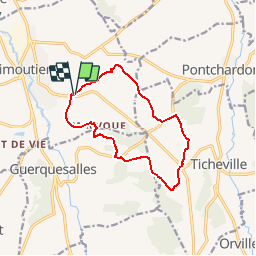
Trail Walking of 11 km to be discovered at Normandy, Orne, Vimoutiers. This trail is proposed by guy.presier.
Description
Balade de 11Km en passant par le château de Vimer transformé en hôpital après les bombardement de Vimoutiers le 14 juin 1944.
Retour par le château du Mézeray.
Positioning
Country:
France
Region :
Normandy
Department/Province :
Orne
Municipality :
Vimoutiers
Location:
Unknown
Start:(Dec)
Start:(UTM)
295982 ; 5422727 (31U) N.
Comments
Trails nearby
![Trail Mountain bike Vimoutiers - Espace VTT FFC du Pays d'Auge Ornais- Circuit n°15 - Plateau du Sap - Photo](https://media.geolcdn.com/t/375/260/ext.jpg?maxdim=2&url=https%3A%2F%2Fservices.sitytrail.com%2FGeolivesWS%2FDownloadMedia.ashx%3FTrailID%3D102043%26Media%3D2364_2.jpg)
![Mountain bike Mountain bike](https://static1.geolcdn.com/sitytour/trail-icons/202.png)
Espace VTT FFC du Pays d'Auge Ornais- Circuit n°15 - Plateau du Sap
Mountain bike
Difficult
(2)
Vimoutiers,
Normandy,
Orne,
France
![](/images/other/stat-length.png)
40 km | 47 km-effort
3h 15min
![](https://static1.geolcdn.com/siteimages/upload/files/16400158638029165_repeat_loop_refresh_sync_direction_icon.png)
Yes
![Trail Walking Lisores - Lisores - Photo](https://media.geolcdn.com/t/375/260/fb89d089-a4c5-4080-be7d-7565f57f6a48.jpg&format=jpg&maxdim=2)
![Walking Walking](https://static1.geolcdn.com/sitytour/trail-icons/101.png)
![Trail 4x4 Lisores - Sortie land61 1/3/20 - Photo](https://media.geolcdn.com/t/375/260/c2c1dcc0-d716-4b78-8e62-a2996a29eb43.jpg&format=jpg&maxdim=2)
![4x4 4x4](https://static1.geolcdn.com/sitytour/trail-icons/403.png)
Sortie land61 1/3/20
4x4
Very difficult
Lisores,
Normandy,
Calvados,
France
![](/images/other/stat-length.png)
38 km | 46 km-effort
3h 32min
![](https://static1.geolcdn.com/siteimages/upload/files/16400158638029165_repeat_loop_refresh_sync_direction_icon.png)
No
![Trail Walking Vimoutiers - Au pays de Marie Harel - Vimoutiers - Photo](https://media.geolcdn.com/t/375/260/ext.jpg?maxdim=2&url=https%3A%2F%2Fservices.sitytrail.com%2FGeolivesWS%2FDownloadMedia.ashx%3FTrailID%3D317650%26Media%3D16926_6.jpg)
![Walking Walking](https://static1.geolcdn.com/sitytour/trail-icons/101.png)
Au pays de Marie Harel - Vimoutiers
Walking
Difficult
Vimoutiers,
Normandy,
Orne,
France
![](/images/other/stat-length.png)
20 km | 24 km-effort
5h 0min
![](https://static1.geolcdn.com/siteimages/upload/files/16400158638029165_repeat_loop_refresh_sync_direction_icon.png)
Yes
![Trail Walking Vimoutiers - Au pays du Camembert - Vimoutiers - Photo](https://media.geolcdn.com/t/375/260/ext.jpg?maxdim=2&url=https%3A%2F%2Fservices.sitytrail.com%2FGeolivesWS%2FDownloadMedia.ashx%3FTrailID%3D111659%26Media%3D7897_3.jpg)
![Walking Walking](https://static1.geolcdn.com/sitytour/trail-icons/101.png)
Au pays du Camembert - Vimoutiers
Walking
Difficult
Vimoutiers,
Normandy,
Orne,
France
![](/images/other/stat-length.png)
18 km | 24 km-effort
5h 0min
![](https://static1.geolcdn.com/siteimages/upload/files/16400158638029165_repeat_loop_refresh_sync_direction_icon.png)
Yes
![Trail Walking Vimoutiers - Vimoutier - Photo](https://media.geolcdn.com/t/375/260/a7564173-ba23-46de-9387-05203aa51f87.jpg&format=jpg&maxdim=2)
![Walking Walking](https://static1.geolcdn.com/sitytour/trail-icons/101.png)
![Trail Walking Canapville - camapville 61 - Photo](https://media.geolcdn.com/t/375/260/02c54343-4376-445b-8cd3-5ab243f48f72.jpg&format=jpg&maxdim=2)
![Walking Walking](https://static1.geolcdn.com/sitytour/trail-icons/101.png)
camapville 61
Walking
Very easy
Canapville,
Normandy,
Orne,
France
![](/images/other/stat-length.png)
13.1 km | 15.3 km-effort
2h 40min
![](https://static1.geolcdn.com/siteimages/upload/files/16400158638029165_repeat_loop_refresh_sync_direction_icon.png)
Yes
![Trail Walking Vimoutiers - Vimoutiers 11102020 - Photo](https://media.geolcdn.com/t/375/260/b9f69f9c-7406-46c7-83b8-8941596ba983.jpg&format=jpg&maxdim=2)
![Walking Walking](https://static1.geolcdn.com/sitytour/trail-icons/101.png)
Vimoutiers 11102020
Walking
Medium
Vimoutiers,
Normandy,
Orne,
France
![](/images/other/stat-length.png)
18.3 km | 25 km-effort
3h 50min
![](https://static1.geolcdn.com/siteimages/upload/files/16400158638029165_repeat_loop_refresh_sync_direction_icon.png)
Yes
![Trail Walking Val-de-Vie - Ste Foy de Montgommery - Photo](https://media.geolcdn.com/t/375/260/cf94b937-e308-4b54-9dcd-889c5442372a.jpg&format=jpg&maxdim=2)
![Walking Walking](https://static1.geolcdn.com/sitytour/trail-icons/101.png)
Ste Foy de Montgommery
Walking
Medium
Val-de-Vie,
Normandy,
Calvados,
France
![](/images/other/stat-length.png)
17.4 km | 21 km-effort
3h 31min
![](https://static1.geolcdn.com/siteimages/upload/files/16400158638029165_repeat_loop_refresh_sync_direction_icon.png)
Yes