![](/images/other/stat-length.png)
![Trail Walking Neuillé-Pont-Pierre - Neuillé-Pont-Pierre circuit nord - Photo](https://media.geolcdn.com/t/1900/400/ext.pjpeg?maxdim=2&url=https%3A%2F%2Fstatic1.geolcdn.com%2Fsiteimages%2Fupload%2Ffiles%2F1553511878bg_sport_marche.png)
Neuillé-Pont-Pierre circuit nord
LEMENIO
User
![Length](/images/other/stat-length.png)
Length
12.9 km
![Max alt](https://static1.geolcdn.com/siteimages/upload/files/1508320355ic_sort_altitude_max_24dp.png)
Max alt
122 m
![Uphill gradient](https://static1.geolcdn.com/siteimages/upload/files/1508320355ic_sort_den_pos_24dp.png)
Uphill gradient
91 m
![Km-Effort](/images/other/stat-length.png)
Km-Effort
14.1 km
![Min alt](https://static1.geolcdn.com/siteimages/upload/files/1508320355ic_sort_altitude_min_24dp.png)
Min alt
80 m
![Downhill gradient](https://static1.geolcdn.com/siteimages/upload/files/1508320355ic_sort_den_neg_24dp.png)
Downhill gradient
89 m
![Boucle](https://static1.geolcdn.com/siteimages/upload/files/16400158638029165_repeat_loop_refresh_sync_direction_icon.png)
Boucle
Yes
Creation date :
2014-12-10 00:00:00.0
Updated on :
2014-12-10 00:00:00.0
![Walking](https://static1.geolcdn.com/sitytour/trail-icons/101.png)
2h56
Difficulty : Easy
![Scan this QR Code to open this trail in the SityTrail application](https://capi.geolives.com/qq0zvz2zws4bq2lad0pu/sitytour/trails/114117/qr.png?size=200)
FREE GPS app for hiking
About
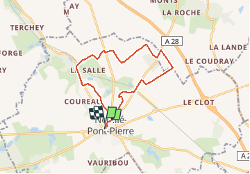
Trail Walking of 12.9 km to be discovered at Centre-Loire Valley, Indre-et-Loire, Neuillé-Pont-Pierre. This trail is proposed by LEMENIO.
Description
Départ Place du Mail. Au lieu-dit "les maisons blanches" traverser la cour pour prendre de chemin (30 mètres). Après la Godardière (à 9,7 Km), 500 mètres de route goudronnée (D68) et prendre le chemin 100 mètres après le passage à niveau.
Positioning
Country:
France
Region :
Centre-Loire Valley
Department/Province :
Indre-et-Loire
Municipality :
Neuillé-Pont-Pierre
Location:
Unknown
Start:(Dec)
Start:(UTM)
315286 ; 5268910 (31T) N.
Comments
Trails nearby
![Trail Walking Neuillé-Pont-Pierre - Neuillé-Pont-Pierre - la Gare - 13.2km 95m 3h00 - 2021 06 06 - Photo](https://media.geolcdn.com/t/375/260/cfc5750c-c28e-4015-8ebd-f7d2fbbd4acb.jpg&format=jpg&maxdim=2)
![Walking Walking](https://static1.geolcdn.com/sitytour/trail-icons/101.png)
Neuillé-Pont-Pierre - la Gare - 13.2km 95m 3h00 - 2021 06 06
Walking
Easy
Neuillé-Pont-Pierre,
Centre-Loire Valley,
Indre-et-Loire,
France
![](/images/other/stat-length.png)
13.2 km | 14.4 km-effort
3h 0min
![](https://static1.geolcdn.com/siteimages/upload/files/16400158638029165_repeat_loop_refresh_sync_direction_icon.png)
Yes
![Trail Walking Neuillé-Pont-Pierre - Neuillé-Pont-Pierre - Circuit 1 - 9.9km 75m 2h00 - 2020 08 22 - Photo](https://media.geolcdn.com/t/375/260/9539092d-241c-4ca6-b996-b5b5dff06d3f.jpg&format=jpg&maxdim=2)
![Walking Walking](https://static1.geolcdn.com/sitytour/trail-icons/101.png)
Neuillé-Pont-Pierre - Circuit 1 - 9.9km 75m 2h00 - 2020 08 22
Walking
Very easy
Neuillé-Pont-Pierre,
Centre-Loire Valley,
Indre-et-Loire,
France
![](/images/other/stat-length.png)
9.9 km | 10.9 km-effort
2h 0min
![](https://static1.geolcdn.com/siteimages/upload/files/16400158638029165_repeat_loop_refresh_sync_direction_icon.png)
Yes
![Trail Walking Sonzay - Sonzay nord - Photo](https://media.geolcdn.com/t/375/260/ext.jpg?maxdim=2&url=https%3A%2F%2Fstatic1.geolcdn.com%2Fsiteimages%2Fupload%2Ffiles%2F1553511878bg_sport_marche.png)
![Walking Walking](https://static1.geolcdn.com/sitytour/trail-icons/101.png)
Sonzay nord
Walking
Very easy
Sonzay,
Centre-Loire Valley,
Indre-et-Loire,
France
![](/images/other/stat-length.png)
9.1 km | 10.2 km-effort
2h 1min
![](https://static1.geolcdn.com/siteimages/upload/files/16400158638029165_repeat_loop_refresh_sync_direction_icon.png)
Yes
![Trail Walking Semblançay - Neuillé Pont Pierre - 8,4 km - Le 10 Juillet 2014 - Auteur tintin37 - Photo](https://media.geolcdn.com/t/375/260/ext.jpg?maxdim=2&url=https%3A%2F%2Fstatic1.geolcdn.com%2Fsiteimages%2Fupload%2Ffiles%2F1553511878bg_sport_marche.png)
![Walking Walking](https://static1.geolcdn.com/sitytour/trail-icons/101.png)
Neuillé Pont Pierre - 8,4 km - Le 10 Juillet 2014 - Auteur tintin37
Walking
Easy
Semblançay,
Centre-Loire Valley,
Indre-et-Loire,
France
![](/images/other/stat-length.png)
8.4 km | 9.2 km-effort
2h 6min
![](https://static1.geolcdn.com/siteimages/upload/files/16400158638029165_repeat_loop_refresh_sync_direction_icon.png)
Yes
![Trail Mountain bike Saint-Paterne-Racan - saint paterne-sonzay - Photo](https://media.geolcdn.com/t/375/260/ext.jpg?maxdim=2&url=https%3A%2F%2Fstatic1.geolcdn.com%2Fsiteimages%2Fupload%2Ffiles%2F1524743154velo.jpg)
![Mountain bike Mountain bike](https://static1.geolcdn.com/sitytour/trail-icons/202.png)
saint paterne-sonzay
Mountain bike
Medium
Saint-Paterne-Racan,
Centre-Loire Valley,
Indre-et-Loire,
France
![](/images/other/stat-length.png)
28 km | 31 km-effort
1h 57min
![](https://static1.geolcdn.com/siteimages/upload/files/16400158638029165_repeat_loop_refresh_sync_direction_icon.png)
Yes
![Trail Walking Neuillé-Pont-Pierre - Neuillé-Pont-Pierre circuit sud - Photo](https://media.geolcdn.com/t/375/260/ext.jpg?maxdim=2&url=https%3A%2F%2Fstatic1.geolcdn.com%2Fsiteimages%2Fupload%2Ffiles%2F1553511878bg_sport_marche.png)
![Walking Walking](https://static1.geolcdn.com/sitytour/trail-icons/101.png)
Neuillé-Pont-Pierre circuit sud
Walking
Easy
Neuillé-Pont-Pierre,
Centre-Loire Valley,
Indre-et-Loire,
France
![](/images/other/stat-length.png)
10.9 km | 12 km-effort
2h 22min
![](https://static1.geolcdn.com/siteimages/upload/files/16400158638029165_repeat_loop_refresh_sync_direction_icon.png)
No
![Trail Walking Sonzay - Sonzay variante chevreuils 12,2km - Photo](https://media.geolcdn.com/t/375/260/ext.jpg?maxdim=2&url=https%3A%2F%2Fstatic1.geolcdn.com%2Fsiteimages%2Fupload%2Ffiles%2F1553511878bg_sport_marche.png)
![Walking Walking](https://static1.geolcdn.com/sitytour/trail-icons/101.png)
Sonzay variante chevreuils 12,2km
Walking
Easy
Sonzay,
Centre-Loire Valley,
Indre-et-Loire,
France
![](/images/other/stat-length.png)
12.2 km | 13.6 km-effort
2h 30min
![](https://static1.geolcdn.com/siteimages/upload/files/16400158638029165_repeat_loop_refresh_sync_direction_icon.png)
Yes
![Trail Walking Semblançay - 2023.12.14 - 8.7 km - Neuillé bois du Moines - Photo](https://media.geolcdn.com/t/375/260/ext.jpg?maxdim=2&url=https%3A%2F%2Fstatic1.geolcdn.com%2Fsiteimages%2Fupload%2Ffiles%2F1553511878bg_sport_marche.png)
![Walking Walking](https://static1.geolcdn.com/sitytour/trail-icons/101.png)
2023.12.14 - 8.7 km - Neuillé bois du Moines
Walking
Medium
Semblançay,
Centre-Loire Valley,
Indre-et-Loire,
France
![](/images/other/stat-length.png)
8.7 km | 9.6 km-effort
2h 29min
![](https://static1.geolcdn.com/siteimages/upload/files/16400158638029165_repeat_loop_refresh_sync_direction_icon.png)
Yes
![Trail Walking Semblançay - Le 2022.10.27-8.7 km-Neuillé Pont Pierre Bois du Mortier aux Moines - Photo](https://media.geolcdn.com/t/375/260/ext.jpg?maxdim=2&url=https%3A%2F%2Fstatic1.geolcdn.com%2Fsiteimages%2Fupload%2Ffiles%2F1553511878bg_sport_marche.png)
![Walking Walking](https://static1.geolcdn.com/sitytour/trail-icons/101.png)
Le 2022.10.27-8.7 km-Neuillé Pont Pierre Bois du Mortier aux Moines
Walking
Medium
Semblançay,
Centre-Loire Valley,
Indre-et-Loire,
France
![](/images/other/stat-length.png)
8.7 km | 9.6 km-effort
2h 26min
![](https://static1.geolcdn.com/siteimages/upload/files/16400158638029165_repeat_loop_refresh_sync_direction_icon.png)
Yes