Trail Walking Sanary-sur-Mer - camping Sanary camping - Photo
 pesce
pesce

User

© OpenStreetMap contributors
Length
Length
18.6 km
Max alt
Max alt
54 m
Uphill gradient
Uphill gradient
167 m
Km-Effort
Km-Effort  
21 km
Min alt
Min alt
0 m
Downhill gradient
Downhill gradient
200 m
Boucle
Boucle
No
Creation date :
2019-05-07 01:29:42.216
Updated on :
2019-05-07 01:29:42.216

(0 Reviews)

Walking
Walking
2h25
Difficulty : Unknown

Scan this QR Code to open this trail in the SityTrail application

FREE GPS app for hiking

Logo SityTrail SityTrail

IGN / Geographical institutes

Download SityTrail from the App Store Download SityTrail from Google Play

Logo SityTrail SityTrail World

The world is yours!

Download SityTrail from the App Store Download SityTrail from Google Play Download SityTrail on Huawei AppGallery

About

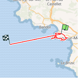
Trail Walking of 18.6 km to be discovered at Provence-Alpes-Côte d'Azur, Var, Sanary-sur-Mer. This trail is proposed by pesce.

Description

camping mogador Sanary retour camping par bord de mer

Elevation profile

Positioning

Country:
France
Region :
Provence-Alpes-Côte d'Azur
Department/Province :
Var
Municipality :
Sanary-sur-Mer
Location:
Unknown
Start:(UTM)
726796 ; 4778322 (31T) N.

Trails nearby

Trail Walking Bandol - SityTrail - fregate - Photo
Walking
GUIDE
affinetataille

Walking

Easy
(1)
Bandol, Provence-Alpes-Côte d'Azur, Var, France
8.7 km | 11.4 km-effort
3h 15min
Yes
Trail Walking Six-Fours-les-Plages - ND de Pepiole via colline du fort de Six-Fours, retour par Les Lônes - Photo
Walking
Daniel.BRUN-PICARD

Walking

Easy
(1)
Six-Fours-les-Plages, Provence-Alpes-Côte d'Azur, Var, France
8.2 km | 10.7 km-effort
3h 0min
Yes
Trail Walking Bandol - SityTrail - Tour du golf de la Fregate (version longue ) - Photo
Walking
GUIDE
affinetataille

Walking

Very difficult
(1)
Bandol, Provence-Alpes-Côte d'Azur, Var, France
13.5 km | 19 km-effort
4h 19min
Yes
Trail Walking Six-Fours-les-Plages - ND de Pepiole via colline du fort de Six-Fours - Photo
Walking
Daniel.BRUN-PICARD

Walking

Easy
(1)
Six-Fours-les-Plages, Provence-Alpes-Côte d'Azur, Var, France
8.7 km | 12.3 km-effort
3h 0min
Yes
Trail Walking Évenos - Sainte Anne d'Evenos Le Gros Cerveau - Photo
Walking
tracegps

Walking

Difficult
(3)
Évenos, Provence-Alpes-Côte d'Azur, Var, France
7 km | 11.8 km-effort
3h 30min
Yes
Trail Walking Bandol - Rando Bandol - Port d'Alon - Bandol - Photo
Walking
tracegps

Walking

Difficult
(1)
Bandol, Provence-Alpes-Côte d'Azur, Var, France
7.2 km | 9.4 km-effort
2h 30min
Yes
Trail Walking Évenos - 83 grès ste anne - Photo
Walking
GUIDE
randodyssée

Walking

Medium
Évenos, Provence-Alpes-Côte d'Azur, Var, France
3.4 km | 6.1 km-effort
2h 23min
Yes
Trail Walking Ollioules - 83 grotte st Martin destel - Photo
Walking
GUIDE
randodyssée

Walking

Medium
Ollioules, Provence-Alpes-Côte d'Azur, Var, France
4.6 km | 8.8 km-effort
5h 28min
Yes
Trail Walking Bandol - SityTrail - Boucle Bandol - Port d'Alon - Dune de sable - La Madrague - Port d'Alon - Bandol - Photo
Walking
GUIDE
affinetataille

Walking

Medium
(2)
Bandol, Provence-Alpes-Côte d'Azur, Var, France
14.1 km | 19.7 km-effort
6h 0min
Yes


Close
My subscriptions