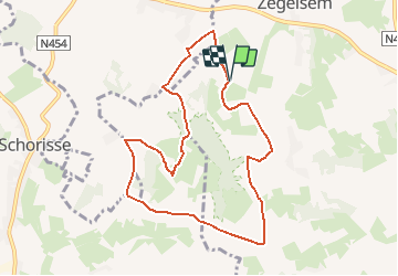
![](/images/other/stat-length.png)
![Trail Walking Brakel - De bronnen van het Burreken - Photo](https://media.geolcdn.com/t/1900/400/ext.pjpeg?maxdim=2&url=https%3A%2F%2Fstatic1.geolcdn.com%2Fsiteimages%2Fupload%2Ffiles%2F1553511878bg_sport_marche.png)
De bronnen van het Burreken
Evasaegerman
User
![Length](/images/other/stat-length.png)
![Max alt](https://static1.geolcdn.com/siteimages/upload/files/1508320355ic_sort_altitude_max_24dp.png)
![Uphill gradient](https://static1.geolcdn.com/siteimages/upload/files/1508320355ic_sort_den_pos_24dp.png)
![Km-Effort](/images/other/stat-length.png)
![Min alt](https://static1.geolcdn.com/siteimages/upload/files/1508320355ic_sort_altitude_min_24dp.png)
![Downhill gradient](https://static1.geolcdn.com/siteimages/upload/files/1508320355ic_sort_den_neg_24dp.png)
![Boucle](https://static1.geolcdn.com/siteimages/upload/files/16400158638029165_repeat_loop_refresh_sync_direction_icon.png)
![Walking](https://static1.geolcdn.com/sitytour/trail-icons/101.png)
--
Difficulty : Easy
![Scan this QR Code to open this trail in the SityTrail application](https://capi.geolives.com/qq0zvz2zws4bq2lad0pu/sitytour/trails/1132923/qr.png?size=200)
FREE GPS app for hiking
About
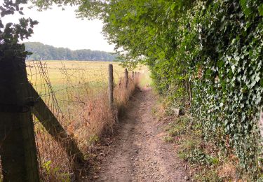
Trail Walking of 8.1 km to be discovered at Flanders, East Flanders, Brakel. This trail is proposed by Evasaegerman.
Description
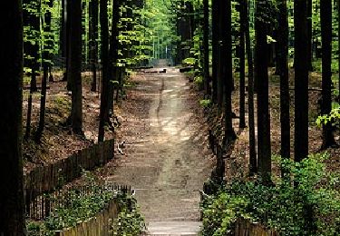
Eén van de meest schilderachtige dorpjes van Vlaanderen, Zegelsem, vormt het startpunt van deze wandeling. Je verkent één van de mooiste stukjes natuur in de Vlaamse Ardennen: Het Burreken. Dit natuurgebied ligt tussen Brakel, Maarkedal en Horebeke verscholen. Door het afwisselende heuvellandschap bekijk het landschap steeds weer opnieuw vanuit een ander oogpunt.
Points of interest
Positioning
Comments
Trails nearby
![Trail On foot Brakel - Toeppad - Photo](https://media.geolcdn.com/t/375/260/09e5ced1-9302-45ec-a2ea-0bc749e41ee5.jpeg&format=jpg&maxdim=2)
![On foot On foot](https://static1.geolcdn.com/sitytour/trail-icons/100.png)
![Trail On foot Brakel - Tweebossenpad - Photo](https://media.geolcdn.com/t/375/260/0ea6d16c-e6be-4ad6-877d-eae169d349af.jpeg&format=jpg&maxdim=2)
![On foot On foot](https://static1.geolcdn.com/sitytour/trail-icons/100.png)
On foot
![](/images/other/stat-length.png)
![](https://static1.geolcdn.com/siteimages/upload/files/16400158638029165_repeat_loop_refresh_sync_direction_icon.png)
![Trail On foot Maarkedal - Muziekboswandeling - Photo](https://media.geolcdn.com/t/375/260/fc075cd6-bf31-4841-9a67-11027de5cfbf.jpeg&format=jpg&maxdim=2)
![On foot On foot](https://static1.geolcdn.com/sitytour/trail-icons/100.png)
On foot
![](/images/other/stat-length.png)
![](https://static1.geolcdn.com/siteimages/upload/files/16400158638029165_repeat_loop_refresh_sync_direction_icon.png)
![Trail On foot Flobecq - Dans le Brakelbos - Photo](https://media.geolcdn.com/t/375/260/ext.jpg?maxdim=2&url=https%3A%2F%2Fpivotmedia.tourismewallonie.be%2FANX-02-000EUU%2FANX-02-000EUU.jpg)
![On foot On foot](https://static1.geolcdn.com/sitytour/trail-icons/100.png)
On foot
![](/images/other/stat-length.png)
![](https://static1.geolcdn.com/siteimages/upload/files/16400158638029165_repeat_loop_refresh_sync_direction_icon.png)
![Trail Walking Maarkedal - TOV - Photo](https://media.geolcdn.com/t/375/260/ext.jpg?maxdim=2&url=https%3A%2F%2Fstatic1.geolcdn.com%2Fsiteimages%2Fupload%2Ffiles%2F1553511878bg_sport_marche.png)
![Walking Walking](https://static1.geolcdn.com/sitytour/trail-icons/101.png)
Walking
![](/images/other/stat-length.png)
![](https://static1.geolcdn.com/siteimages/upload/files/16400158638029165_repeat_loop_refresh_sync_direction_icon.png)
![Trail Walking Maarkedal - Louise-Marie 10,6 km - Photo](https://media.geolcdn.com/t/375/260/6023404c-b086-4737-b987-9220bedc6186.jpg&format=jpg&maxdim=2)
![Walking Walking](https://static1.geolcdn.com/sitytour/trail-icons/101.png)
Walking
![](/images/other/stat-length.png)
![](https://static1.geolcdn.com/siteimages/upload/files/16400158638029165_repeat_loop_refresh_sync_direction_icon.png)
![Trail Walking Maarkedal - Schorisse 15 km - Photo](https://media.geolcdn.com/t/375/260/0c4906d8-a1ee-498e-88c8-dff0ab201549.jpg&format=jpg&maxdim=2)
![Walking Walking](https://static1.geolcdn.com/sitytour/trail-icons/101.png)
Walking
![](/images/other/stat-length.png)
![](https://static1.geolcdn.com/siteimages/upload/files/16400158638029165_repeat_loop_refresh_sync_direction_icon.png)
![Trail Walking Zwalm - Sint-Blasius Boeckel 16,2 km - Photo](https://media.geolcdn.com/t/375/260/a23d2ae7-4c1c-4f06-8319-0207cd98ef62.jpg&format=jpg&maxdim=2)
![Walking Walking](https://static1.geolcdn.com/sitytour/trail-icons/101.png)
Walking
![](/images/other/stat-length.png)
![](https://static1.geolcdn.com/siteimages/upload/files/16400158638029165_repeat_loop_refresh_sync_direction_icon.png)
![Trail Walking Maarkedal - Louise Marie 12,7 km - Photo](https://media.geolcdn.com/t/375/260/ed2c1723-3b5d-420e-ad50-3366af758796.jpg&format=jpg&maxdim=2)
![Walking Walking](https://static1.geolcdn.com/sitytour/trail-icons/101.png)
Walking
![](/images/other/stat-length.png)
![](https://static1.geolcdn.com/siteimages/upload/files/16400158638029165_repeat_loop_refresh_sync_direction_icon.png)