![](/images/other/stat-length.png)
![Trail Walking Allemagne-en-Provence - Allemagne-en-Provence - Photo](https://media.geolcdn.com/t/1900/400/ext.pjpeg?maxdim=2&url=https%3A%2F%2Fservices.sitytrail.com%2FGeolivesWS%2FDownloadMedia.ashx%3FTrailID%3D1132383%26Media%3D5be306e1-af1e-4974-9647-490a25c43c91.jpg)
Allemagne-en-Provence
aubr
User
![Length](/images/other/stat-length.png)
![Max alt](https://static1.geolcdn.com/siteimages/upload/files/1508320355ic_sort_altitude_max_24dp.png)
![Uphill gradient](https://static1.geolcdn.com/siteimages/upload/files/1508320355ic_sort_den_pos_24dp.png)
![Km-Effort](/images/other/stat-length.png)
![Min alt](https://static1.geolcdn.com/siteimages/upload/files/1508320355ic_sort_altitude_min_24dp.png)
![Downhill gradient](https://static1.geolcdn.com/siteimages/upload/files/1508320355ic_sort_den_neg_24dp.png)
![Boucle](https://static1.geolcdn.com/siteimages/upload/files/16400158638029165_repeat_loop_refresh_sync_direction_icon.png)
![Walking](https://static1.geolcdn.com/sitytour/trail-icons/101.png)
1h58
Difficulty : Medium
![Scan this QR Code to open this trail in the SityTrail application](https://capi.geolives.com/qq0zvz2zws4bq2lad0pu/sitytour/trails/1132383/qr.png?size=200)
FREE GPS app for hiking
About
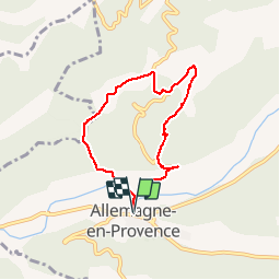
Trail Walking of 6.6 km to be discovered at Provence-Alpes-Côte d'Azur, Alpes-de-Haute-Provence, Allemagne-en-Provence. This trail is proposed by aubr.
Description
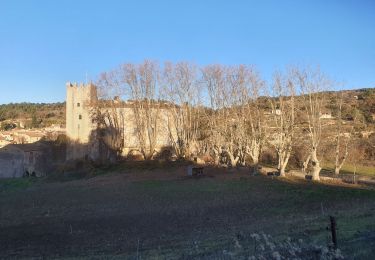
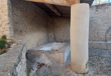
Boucle au départ du parking devant le château des Castellane
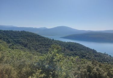
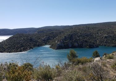
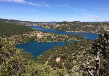
Sentier facile sur le haut qui emprunte le GR4 parmi les lavandes et chênes et vue sur les montagnes environnantes.
Chemin de montée longue et de descente difficile en raison des galets.
Positioning
Comments
Trails nearby
![Trail Walking Esparron-de-Verdon - 2023-01-10 Esparron - Côte de Vauclare - Photo](https://media.geolcdn.com/t/375/260/951ab175-50b2-413c-87ac-de9cf4d2a97c.jpg&format=jpg&maxdim=2)
![Walking Walking](https://static1.geolcdn.com/sitytour/trail-icons/101.png)
Walking
![](/images/other/stat-length.png)
![](https://static1.geolcdn.com/siteimages/upload/files/16400158638029165_repeat_loop_refresh_sync_direction_icon.png)
![Trail Walking Valensole - TOUR DESLAVANDES A VALENSOLE - Photo](https://media.geolcdn.com/t/375/260/ext.jpg?maxdim=2&url=https%3A%2F%2Fstatic1.geolcdn.com%2Fsiteimages%2Fupload%2Ffiles%2F1553511878bg_sport_marche.png)
![Walking Walking](https://static1.geolcdn.com/sitytour/trail-icons/101.png)
Walking
![](/images/other/stat-length.png)
![](https://static1.geolcdn.com/siteimages/upload/files/16400158638029165_repeat_loop_refresh_sync_direction_icon.png)
![Trail Walking Esparron-de-Verdon - esparron - Photo](https://media.geolcdn.com/t/375/260/ext.jpg?maxdim=2&url=https%3A%2F%2Fstatic1.geolcdn.com%2Fsiteimages%2Fupload%2Ffiles%2F1553511878bg_sport_marche.png)
![Walking Walking](https://static1.geolcdn.com/sitytour/trail-icons/101.png)
Walking
![](/images/other/stat-length.png)
![](https://static1.geolcdn.com/siteimages/upload/files/16400158638029165_repeat_loop_refresh_sync_direction_icon.png)
![Trail Electric bike Esparron-de-Verdon - Espérons Ste Croix et retour - Photo](https://media.geolcdn.com/t/375/260/38155cb3-abc4-4bcf-9e58-4f4b9734ae23.jpg&format=jpg&maxdim=2)
![Electric bike Electric bike](https://static1.geolcdn.com/sitytour/trail-icons/205.png)
Electric bike
![](/images/other/stat-length.png)
![](https://static1.geolcdn.com/siteimages/upload/files/16400158638029165_repeat_loop_refresh_sync_direction_icon.png)
![Trail Walking Esparron-de-Verdon - 2024-01-16 Esparron - Source des Cades - Photo](https://media.geolcdn.com/t/375/260/7a161d18-ce57-44bc-85cf-7404a3929f51.jpg&format=jpg&maxdim=2)
![Walking Walking](https://static1.geolcdn.com/sitytour/trail-icons/101.png)
Walking
![](/images/other/stat-length.png)
![](https://static1.geolcdn.com/siteimages/upload/files/16400158638029165_repeat_loop_refresh_sync_direction_icon.png)
![Trail Walking Esparron-de-Verdon - ESPARON DU VERDON . LA CARAIRE . SALLE A MANGER O M - Photo](https://media.geolcdn.com/t/375/260/7994041e-01f0-490e-9009-841a015816ce.jpg&format=jpg&maxdim=2)
![Walking Walking](https://static1.geolcdn.com/sitytour/trail-icons/101.png)
Walking
![](/images/other/stat-length.png)
![](https://static1.geolcdn.com/siteimages/upload/files/16400158638029165_repeat_loop_refresh_sync_direction_icon.png)
![Trail Electric bike Saint-Martin-de-Brômes - 04 - Gréoux-les-Bains boucle - Photo](https://media.geolcdn.com/t/375/260/7f1bbae1-091a-4c72-8da4-8a3e9ba7678c.jpg&format=jpg&maxdim=2)
![Electric bike Electric bike](https://static1.geolcdn.com/sitytour/trail-icons/205.png)
Electric bike
![](/images/other/stat-length.png)
![](https://static1.geolcdn.com/siteimages/upload/files/16400158638029165_repeat_loop_refresh_sync_direction_icon.png)
![Trail Walking Saint-Martin-de-Brômes - Entre lac et rivière.Saint Martin de Brômes - Photo](https://media.geolcdn.com/t/375/260/cbd53e0b-a69d-45e7-88ae-9ff3f6773d7a.jpg&format=jpg&maxdim=2)
![Walking Walking](https://static1.geolcdn.com/sitytour/trail-icons/101.png)
Walking
![](/images/other/stat-length.png)
![](https://static1.geolcdn.com/siteimages/upload/files/16400158638029165_repeat_loop_refresh_sync_direction_icon.png)
![Trail On foot Esparron-de-Verdon - Esparron de Verdon - Photo](https://media.geolcdn.com/t/375/260/2a9eed8b-4012-4f7b-be84-855adc5f3ef0.jpg&format=jpg&maxdim=2)
![On foot On foot](https://static1.geolcdn.com/sitytour/trail-icons/100.png)
On foot
![](/images/other/stat-length.png)
![](https://static1.geolcdn.com/siteimages/upload/files/16400158638029165_repeat_loop_refresh_sync_direction_icon.png)