Trail Walking Arinsal - And El Pic de Coma Pedrosa - Photo

And El Pic de Coma Pedrosa

 phidge
phidge

User

© OpenStreetMap contributors
Length
Length
12.7 km
Max alt
Max alt
2916 m
Uphill gradient
Uphill gradient
1360 m
Km-Effort
Km-Effort  
31 km
Min alt
Min alt
1574 m
Downhill gradient
Downhill gradient
1361 m
Boucle
Boucle
Yes
Creation date :
2019-01-19 21:16:45.136
Updated on :
2019-01-19 21:16:45.146

(0 Reviews)

Walking
Walking
--
Difficulty : Difficult

Scan this QR Code to open this trail in the SityTrail application

FREE GPS app for hiking

Logo SityTrail SityTrail

IGN / Geographical institutes

Download SityTrail from the App Store Download SityTrail from Google Play

Logo SityTrail SityTrail World

The world is yours!

Download SityTrail from the App Store Download SityTrail from Google Play Download SityTrail on Huawei AppGallery

About

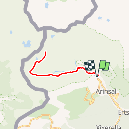
Trail Walking of 12.7 km to be discovered at Andorra. This trail is proposed by phidge.

Description

Longueur: 13,22 kilomètres
Altitude min: 1 555 mètres, max: 2 948 mètres
Dénivelé cum. montée: 1 414 mètres, descente: 1 390 mètres
Degré de difficulté: skill Modéré
Durée:   8 hours 40 minutes

Ascensio al pic mes alt d'Andorra facil pero amb un fort desnivell

Elevation profile

Positioning

Country:
Andorra
Region :
La Massana
Department/Province :
La Massana
Municipality :
Arinsal
Location:
Unknown
Start:(Dec)
Start:(UTM)
375158 ; 4715233 (31T) N.

Comments

Please log in to post a review or rate the element


Trails nearby

Trail Walking  - llorts_lac_angonella - Photo
Walking
fabtlsm

Walking

Very easy
(1)
, , , Andorra
10.4 km | 23 km-effort
5h 29min
Yes
Trail Walking  - Andorre TSM groupe 2 mardi 10 septembre après-midi  - Photo
Walking
zanogueb

Walking

Very easy
, , , Andorra
4.4 km | 5 km-effort
2h 22min
No
Trail Walking Auzat - étang de Medecourbe - Photo
Walking
rolandariege

Walking

Very easy
Auzat, Occitania, Ariège, France
5.5 km | 8 km-effort
2h 7min
No
Trail Walking  - El-Serat - Lac Estany Approximatif - Photo
Walking
phidge

Walking

Difficult
, , , Andorra
9.1 km | 22 km-effort
5min
No
Trail Motor  - a-spanje-bergen-andorra-en-spanje - Photo
Motor
gpstracks

Motor

Very easy
, , , Andorra
219 km | 497 km-effort
Unknown
Yes
Trail Walking  - Arinsal - Arans -Lliort - Photo
Walking
phidge

Walking

Medium
, , , Andorra
16.1 km | 41 km-effort
Unknown
Yes
Trail Walking  - 27 Llorts / Lacs de l'Angonella - Photo
Walking
phidge

Walking

Medium
, , , Andorra
11.2 km | 25 km-effort
Unknown
Yes
Trail Walking  - And : Cami Solà- Camí Obaga - Photo
Walking
phidge

Walking

Easy
, , , Andorra
8.2 km | 17.5 km-effort
Unknown
No
Trail Walking  - And Pics de Cataperdís, de l'Angonella i d'Arcalís - Photo
Walking
phidge

Walking

Difficult
, , , Andorra
5.5 km | 12.3 km-effort
Unknown
Yes


Close
My subscriptions