Trail Walking Villars - Villars abbaye de Boschaud - Photo

Villars abbaye de Boschaud

© OpenStreetMap contributors
Length
Length
12.4 km
Max alt
Max alt
209 m
Uphill gradient
Uphill gradient
259 m
Km-Effort
Km-Effort  
15.8 km
Min alt
Min alt
136 m
Downhill gradient
Downhill gradient
255 m
Boucle
Boucle
Yes
Creation date :
2019-03-30 16:30:19.034
Updated on :
2019-03-30 18:21:38.001

(0 Reviews)

Walking
Walking
3h58
Difficulty : Medium

Scan this QR Code to open this trail in the SityTrail application

FREE GPS app for hiking

Logo SityTrail SityTrail

IGN / Geographical institutes

Download SityTrail from the App Store Download SityTrail from Google Play

Logo SityTrail SityTrail World

The world is yours!

Download SityTrail from the App Store Download SityTrail from Google Play Download SityTrail on Huawei AppGallery

About

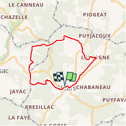
Trail Walking of 12.4 km to be discovered at New Aquitaine, Dordogne, Villars. This trail is proposed by rougilabuse.

Description

Départ sur le parking de la mairie de Villars le chemin est en partie balisé jaune. une petit partie ne l'est pas ou du moins mal indiquée. ne l'absence de balise bien suivre le tracé gps.  une portion qui peux faire douter est indiqué sur le parcours.

Elevation profile

Photos

Points of interest

Point of interest Villars - Abbaye de Boschaud - Photo
rougilabuse
Point of interest Quinsac - balisage inexistant  - Photo
rougilabuse
Point of interest Quinsac - chemin pas tres visible - Photo
rougilabuse

Positioning

Country:
France
Region :
New Aquitaine
Department/Province :
Dordogne
Municipality :
Villars
Location:
Unknown
Start:(UTM)
324170 ; 5032110 (31T) N.

Trails nearby

Trail Walking Villars - Puyguilhem - Grotte de Villars - Photo
Walking
Zygomat

Walking

Difficult
(1)
Villars, New Aquitaine, Dordogne, France
13.6 km | 17.1 km-effort
3h 44min
Yes
Trail Walking Villars - Villars Quinsac - Photo
Walking
YV24

Walking

Easy
(1)
Villars, New Aquitaine, Dordogne, France
13 km | 16.3 km-effort
3h 30min
Yes
Trail Electric bike Villars - Villars -Nontron 10/09/22 - Photo
Electric bike
zoe.vienne

Electric bike

Easy
Villars, New Aquitaine, Dordogne, France
34 km | 41 km-effort
2h 40min
No
Trail Walking Villars - randogps24-488 - Photo
Walking
swp648

Walking

Difficult
Villars, New Aquitaine, Dordogne, France
12.3 km | 15.7 km-effort
3h 34min
Yes
Trail Walking Champagnac-de-Belair - Boucle de Champagnac de bel air - Photo
Walking
Patricew

Walking

Difficult
Champagnac-de-Belair, New Aquitaine, Dordogne, France
12.7 km | 15.7 km-effort
3h 33min
Yes
Trail Mountain bike Villars - Mareuil Pauliac Brantôme Pressillac - Photo
Mountain bike
charrier

Mountain bike

Medium
Villars, New Aquitaine, Dordogne, France
109 km | 136 km-effort
8h 23min
Yes
Trail Walking Saint-Pierre-de-Côle - St Pierre de Côle Bruzac courte 12km - Photo
Walking
YV24

Walking

Easy
Saint-Pierre-de-Côle, New Aquitaine, Dordogne, France
11.5 km | 14.5 km-effort
3h 10min
Yes
Trail Walking Condat-sur-Trincou - Condat-sur-Trincou Dronne Trincou 13km - Photo
Walking
YV24

Walking

Easy
Condat-sur-Trincou, New Aquitaine, Dordogne, France
12.6 km | 15.8 km-effort
3h 26min
Yes
Trail Walking Champagnac-de-Belair - Champagnac Belair Drone Trincou - Photo
Walking
YV24

Walking

Easy
Champagnac-de-Belair, New Aquitaine, Dordogne, France
13.4 km | 16.7 km-effort
3h 36min
Yes


Close
My subscriptions