![](/images/other/stat-length.png)
![Trail Cycle Orgelet - Escapade médiévale autour d'Orgelet - Photo](https://media.geolcdn.com/t/1900/400/ext.pjpeg?maxdim=2&url=https%3A%2F%2Fservices.sitytrail.com%2FGeolivesWS%2FDownloadMedia.ashx%3FTrailID%3D112841%26Media%3D12600_6.jpg)
Escapade médiévale autour d'Orgelet
tracegps
User
![Length](/images/other/stat-length.png)
![Max alt](https://static1.geolcdn.com/siteimages/upload/files/1508320355ic_sort_altitude_max_24dp.png)
![Uphill gradient](https://static1.geolcdn.com/siteimages/upload/files/1508320355ic_sort_den_pos_24dp.png)
![Km-Effort](/images/other/stat-length.png)
![Min alt](https://static1.geolcdn.com/siteimages/upload/files/1508320355ic_sort_altitude_min_24dp.png)
![Downhill gradient](https://static1.geolcdn.com/siteimages/upload/files/1508320355ic_sort_den_neg_24dp.png)
![Boucle](https://static1.geolcdn.com/siteimages/upload/files/16400158638029165_repeat_loop_refresh_sync_direction_icon.png)
![Cycle](https://static1.geolcdn.com/sitytour/trail-icons/200.png)
1h49
Difficulty : Medium
![Scan this QR Code to open this trail in the SityTrail application](https://capi.geolives.com/qq0zvz2zws4bq2lad0pu/sitytour/trails/112841/qr.png?size=200)
FREE GPS app for hiking
About
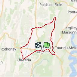
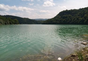
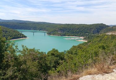
Trail Cycle of 26 km to be discovered at Bourgogne-Franche-Comté, Jura, Orgelet. This trail is proposed by tracegps.
Description
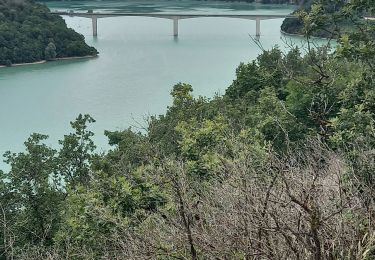
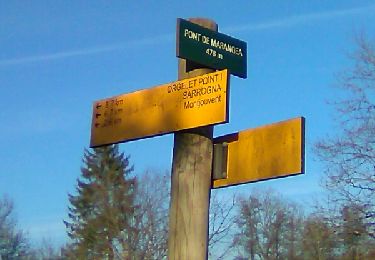
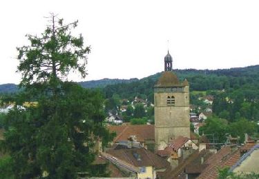
Circuit proposé par l'Office de Tourisme des lacs et petite montagne. Pas plus tranquille que ces petites routes, pour les amateurs de patrimoine, les ruines du château de Présilly, avec sentier de découverte et vue sur les Monts Jura, le château de Mérona et Orgelet, petite citée comtoise de caractère. Départ d'Orgelet. Un carnet de 16 fiches cyclo, en vente 5 € à l’Office de Tourisme, propose des circuits cyclo autour des lacs et en Petite Montagne de 15 à 100 km sur des petites routes tranquilles sans trop de dénivelé pour découvrir les curiosités de la région.
Positioning
Comments
Trails nearby
![Trail Mountain bike La Tour-du-Meix - Lac de Vouglans nord - La Tour-du-Meix - Photo](https://media.geolcdn.com/t/375/260/ext.jpg?maxdim=2&url=https%3A%2F%2Fservices.sitytrail.com%2FGeolivesWS%2FDownloadMedia.ashx%3FTrailID%3D316855%26Media%3D15926_6.jpg)
![Mountain bike Mountain bike](https://static1.geolcdn.com/sitytour/trail-icons/202.png)
Mountain bike
![](/images/other/stat-length.png)
![](https://static1.geolcdn.com/siteimages/upload/files/16400158638029165_repeat_loop_refresh_sync_direction_icon.png)
![Trail Walking La Tour-du-Meix - Vouglans depuis St Christophe - Photo](https://media.geolcdn.com/t/375/260/9bd36762-f5cb-4dda-8f17-5a560c7ed3be.jpg&format=jpg&maxdim=2)
![Walking Walking](https://static1.geolcdn.com/sitytour/trail-icons/101.png)
Walking
![](/images/other/stat-length.png)
![](https://static1.geolcdn.com/siteimages/upload/files/16400158638029165_repeat_loop_refresh_sync_direction_icon.png)
![Trail Walking La Tour-du-Meix - St Christophe - Photo](https://media.geolcdn.com/t/375/260/0205dbdc-6013-448b-89e7-ce63ee72b2d9.jpg&format=jpg&maxdim=2)
![Walking Walking](https://static1.geolcdn.com/sitytour/trail-icons/101.png)
Walking
![](/images/other/stat-length.png)
![](https://static1.geolcdn.com/siteimages/upload/files/16400158638029165_repeat_loop_refresh_sync_direction_icon.png)
![Trail Mountain bike La Tour-du-Meix - Jura - La tour du Meix VTT - Photo](https://media.geolcdn.com/t/375/260/0c7a1581-db28-406e-977d-d4746d698e0b.jpg&format=jpg&maxdim=2)
![Mountain bike Mountain bike](https://static1.geolcdn.com/sitytour/trail-icons/202.png)
Mountain bike
![](/images/other/stat-length.png)
![](https://static1.geolcdn.com/siteimages/upload/files/16400158638029165_repeat_loop_refresh_sync_direction_icon.png)
![Trail On foot Dompierre-sur-Mont - Sentier Nature - Photo](https://media.geolcdn.com/t/375/260/1a3f07bd-d187-4f4e-ba44-a642a5d0288a.jpeg&format=jpg&maxdim=2)
![On foot On foot](https://static1.geolcdn.com/sitytour/trail-icons/100.png)
On foot
![](/images/other/stat-length.png)
![](https://static1.geolcdn.com/siteimages/upload/files/16400158638029165_repeat_loop_refresh_sync_direction_icon.png)
![Trail Walking Écrille - haute vallée de la valouse - Photo](https://media.geolcdn.com/t/375/260/f4ee78c6-c78f-4bbe-a41f-50bb3d45a2ca.jpg&format=jpg&maxdim=2)
![Walking Walking](https://static1.geolcdn.com/sitytour/trail-icons/101.png)
Walking
![](/images/other/stat-length.png)
![](https://static1.geolcdn.com/siteimages/upload/files/16400158638029165_repeat_loop_refresh_sync_direction_icon.png)
![Trail Walking La Tour-du-Meix - Le pont de la pyle - Photo](https://media.geolcdn.com/t/375/260/7aa1f4c6-c492-4b91-af4e-a7a58ac922fa.jpg&format=jpg&maxdim=2)
![Walking Walking](https://static1.geolcdn.com/sitytour/trail-icons/101.png)
Walking
![](/images/other/stat-length.png)
![](https://static1.geolcdn.com/siteimages/upload/files/16400158638029165_repeat_loop_refresh_sync_direction_icon.png)
![Trail Walking Écrille - Ecrille-Bords de la Valouse - Photo](https://media.geolcdn.com/t/375/260/ext.jpg?maxdim=2&url=https%3A%2F%2Fservices.sitytrail.com%2FGeolivesWS%2FDownloadMedia.ashx%3FTrailID%3D856967%26Media%3Dfix__20171103155602.jpg)
![Walking Walking](https://static1.geolcdn.com/sitytour/trail-icons/101.png)
Walking
![](/images/other/stat-length.png)
![](https://static1.geolcdn.com/siteimages/upload/files/16400158638029165_repeat_loop_refresh_sync_direction_icon.png)
![Trail Cycle Orgelet - Entre lacs et chapelles - Orgelet - Photo](https://media.geolcdn.com/t/375/260/ext.jpg?maxdim=2&url=https%3A%2F%2Fservices.sitytrail.com%2FGeolivesWS%2FDownloadMedia.ashx%3FTrailID%3D112844%26Media%3D12609_6.jpg)
![Cycle Cycle](https://static1.geolcdn.com/sitytour/trail-icons/200.png)
Cycle
![](/images/other/stat-length.png)
![](https://static1.geolcdn.com/siteimages/upload/files/16400158638029165_repeat_loop_refresh_sync_direction_icon.png)
Leuke en afwisselende fietstocht. Goed te doen met de elektrische fiets. Op tweederde van de tocht een langere klim.