![](/images/other/stat-length.png)
![Trail Walking Autruche - Autour d'Autruche - Photo](https://media.geolcdn.com/t/1900/400/ext.pjpeg?maxdim=2&url=https%3A%2F%2Fservices.sitytrail.com%2FGeolivesWS%2FDownloadMedia.ashx%3FTrailID%3D112829%26Media%3D12552_4.jpg)
Autour d'Autruche
tracegps
User
![Length](/images/other/stat-length.png)
Length
10 km
![Max alt](https://static1.geolcdn.com/siteimages/upload/files/1508320355ic_sort_altitude_max_24dp.png)
Max alt
242 m
![Uphill gradient](https://static1.geolcdn.com/siteimages/upload/files/1508320355ic_sort_den_pos_24dp.png)
Uphill gradient
143 m
![Km-Effort](/images/other/stat-length.png)
Km-Effort
11.9 km
![Min alt](https://static1.geolcdn.com/siteimages/upload/files/1508320355ic_sort_altitude_min_24dp.png)
Min alt
172 m
![Downhill gradient](https://static1.geolcdn.com/siteimages/upload/files/1508320355ic_sort_den_neg_24dp.png)
Downhill gradient
143 m
![Boucle](https://static1.geolcdn.com/siteimages/upload/files/16400158638029165_repeat_loop_refresh_sync_direction_icon.png)
Boucle
Yes
Creation date :
2014-12-10 00:00:00.0
Updated on :
2014-12-10 00:00:00.0
![Walking](https://static1.geolcdn.com/sitytour/trail-icons/101.png)
2h30
Difficulty : Medium
![Scan this QR Code to open this trail in the SityTrail application](https://capi.geolives.com/qq0zvz2zws4bq2lad0pu/sitytour/trails/112829/qr.png?size=200)
FREE GPS app for hiking
About
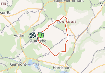
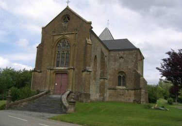
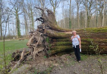
Trail Walking of 10 km to be discovered at Grand Est, Ardennes, Autruche. This trail is proposed by tracegps.
Description
Circuit proposé par la commune de Le Chesne et le Comité d'Animation Cantonale. Départ de la mairie d'Autruche. Retrouvez le circuit et son descriptif sur le site de la commune de Le Chesne.
Positioning
Country:
France
Region :
Grand Est
Department/Province :
Ardennes
Municipality :
Autruche
Location:
Unknown
Start:(Dec)
Start:(UTM)
637669 ; 5479707 (31U) N.
Comments
Trails nearby
![Trail On foot Buzancy - La Chapelle de Masmes - Photo](https://media.geolcdn.com/t/375/260/1ba88a5e-476b-495e-87eb-836291ac2ca5.jpeg&format=jpg&maxdim=2)
![On foot On foot](https://static1.geolcdn.com/sitytour/trail-icons/100.png)
La Chapelle de Masmes
On foot
Easy
Buzancy,
Grand Est,
Ardennes,
France
![](/images/other/stat-length.png)
11.4 km | 14.1 km-effort
3h 11min
![](https://static1.geolcdn.com/siteimages/upload/files/16400158638029165_repeat_loop_refresh_sync_direction_icon.png)
Yes
![Trail Walking Saint-Pierremont - De St Pierremont à Vaux en Dieulet - Photo](https://media.geolcdn.com/t/375/260/ext.jpg?maxdim=2&url=https%3A%2F%2Fservices.sitytrail.com%2FGeolivesWS%2FDownloadMedia.ashx%3FTrailID%3D172836%26Media%3D14275_6.jpg)
![Walking Walking](https://static1.geolcdn.com/sitytour/trail-icons/101.png)
De St Pierremont à Vaux en Dieulet
Walking
Difficult
Saint-Pierremont,
Grand Est,
Ardennes,
France
![](/images/other/stat-length.png)
16.3 km | 19.9 km-effort
3h 34min
![](https://static1.geolcdn.com/siteimages/upload/files/16400158638029165_repeat_loop_refresh_sync_direction_icon.png)
Yes
![Trail Mountain bike Autruche - Autour d'Autruche - Photo](https://media.geolcdn.com/t/375/260/ext.jpg?maxdim=2&url=https%3A%2F%2Fservices.sitytrail.com%2FGeolivesWS%2FDownloadMedia.ashx%3FTrailID%3D112830%26Media%3D12552_2.jpg)
![Mountain bike Mountain bike](https://static1.geolcdn.com/sitytour/trail-icons/202.png)
Autour d'Autruche
Mountain bike
Easy
Autruche,
Grand Est,
Ardennes,
France
![](/images/other/stat-length.png)
10 km | 11.9 km-effort
30min
![](https://static1.geolcdn.com/siteimages/upload/files/16400158638029165_repeat_loop_refresh_sync_direction_icon.png)
Yes
![Trail Walking Boult-aux-Bois - Projet AA Boult aux bois](https://media.geolcdn.com/t/375/260/d40d4cc3-566e-430c-9fc1-38aee142d01e.jpg&format=jpg&maxdim=2)
![Walking Walking](https://static1.geolcdn.com/sitytour/trail-icons/101.png)
Projet AA Boult aux bois " Sentier des Templiers "
Walking
Difficult
Boult-aux-Bois,
Grand Est,
Ardennes,
France
![](/images/other/stat-length.png)
10.2 km | 12.8 km-effort
2h 54min
![](https://static1.geolcdn.com/siteimages/upload/files/16400158638029165_repeat_loop_refresh_sync_direction_icon.png)
Yes
![Trail Electric bike Buzancy - Balade en forêt d'Argonne - Photo](https://media.geolcdn.com/t/375/260/ext.jpg?maxdim=2&url=https%3A%2F%2Fstatic1.geolcdn.com%2Fsiteimages%2Fupload%2Ffiles%2F1524743154velo.jpg)
![Electric bike Electric bike](https://static1.geolcdn.com/sitytour/trail-icons/205.png)
Balade en forêt d'Argonne
Electric bike
Very easy
Buzancy,
Grand Est,
Ardennes,
France
![](/images/other/stat-length.png)
33 km | 37 km-effort
Unknown
![](https://static1.geolcdn.com/siteimages/upload/files/16400158638029165_repeat_loop_refresh_sync_direction_icon.png)
Yes
![Trail Cycle Buzancy - f-frankrijk-rond-buzancy - Photo](https://media.geolcdn.com/t/375/260/ext.jpg?maxdim=2&url=https%3A%2F%2Fstatic1.geolcdn.com%2Fsiteimages%2Fupload%2Ffiles%2F1524743154velo.jpg)
![Cycle Cycle](https://static1.geolcdn.com/sitytour/trail-icons/200.png)
f-frankrijk-rond-buzancy
Cycle
Very easy
Buzancy,
Grand Est,
Ardennes,
France
![](/images/other/stat-length.png)
41 km | 48 km-effort
Unknown
![](https://static1.geolcdn.com/siteimages/upload/files/16400158638029165_repeat_loop_refresh_sync_direction_icon.png)
Yes
![Trail Walking Buzancy - w-frankrijk-de-omgeving-van-buzancy-te-voet - Photo](https://media.geolcdn.com/t/375/260/ext.jpg?maxdim=2&url=https%3A%2F%2Fstatic1.geolcdn.com%2Fsiteimages%2Fupload%2Ffiles%2F1553511878bg_sport_marche.png)
![Walking Walking](https://static1.geolcdn.com/sitytour/trail-icons/101.png)
w-frankrijk-de-omgeving-van-buzancy-te-voet
Walking
Very easy
Buzancy,
Grand Est,
Ardennes,
France
![](/images/other/stat-length.png)
12.1 km | 14.7 km-effort
Unknown
![](https://static1.geolcdn.com/siteimages/upload/files/16400158638029165_repeat_loop_refresh_sync_direction_icon.png)
Yes