![](/images/other/stat-length.png)
![Trail Cycle Estissac - Circuit d'Etissac - Photo](https://media.geolcdn.com/t/1900/400/ext.pjpeg?maxdim=2&url=https%3A%2F%2Fservices.sitytrail.com%2FGeolivesWS%2FDownloadMedia.ashx%3FTrailID%3D112785%26Media%3D12392_5.jpg)
Circuit d'Etissac
tracegps
User
![Length](/images/other/stat-length.png)
![Max alt](https://static1.geolcdn.com/siteimages/upload/files/1508320355ic_sort_altitude_max_24dp.png)
![Uphill gradient](https://static1.geolcdn.com/siteimages/upload/files/1508320355ic_sort_den_pos_24dp.png)
![Km-Effort](/images/other/stat-length.png)
![Min alt](https://static1.geolcdn.com/siteimages/upload/files/1508320355ic_sort_altitude_min_24dp.png)
![Downhill gradient](https://static1.geolcdn.com/siteimages/upload/files/1508320355ic_sort_den_neg_24dp.png)
![Boucle](https://static1.geolcdn.com/siteimages/upload/files/16400158638029165_repeat_loop_refresh_sync_direction_icon.png)
![Cycle](https://static1.geolcdn.com/sitytour/trail-icons/200.png)
1h30
Difficulty : Easy
![Scan this QR Code to open this trail in the SityTrail application](https://capi.geolives.com/qq0zvz2zws4bq2lad0pu/sitytour/trails/112785/qr.png?size=200)
FREE GPS app for hiking
About
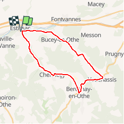
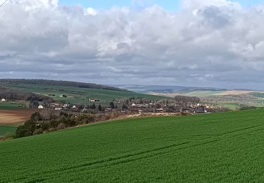
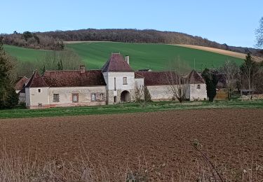
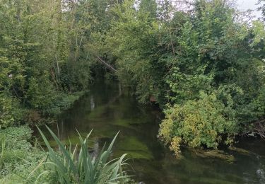
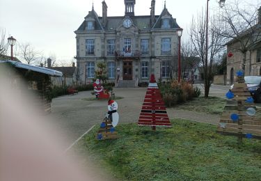
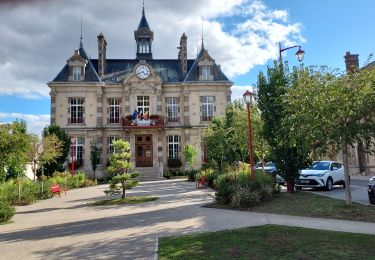
Trail Cycle of 25 km to be discovered at Grand Est, Aube, Estissac. This trail is proposed by tracegps.
Description
Circuit proposé par l'office de Tourisme du Pays d'Othe, vallée de la Vanne et le Cyclo Club Othéen. Départ place de la mairie d'Etissac. La halle d'Estissac fut dressée durant la première partie du XVIIIème siècle en tant qu'élément du domaine seigneurial. Elle sert d'abri au pressoir et sert également de lieu de marché à grains et de foires. La municipalité l'achète en 1801. Un marché s'y tient le dimanche matin depuis le XXème siècle. Retrouvez le circuit a télécharger sur le site de l'office de tourisme du Pays d'Othe, vallée de la Vanne.
Positioning
Comments
Trails nearby
![Trail Walking Bucey-en-Othe - Au dessus de BUCEY EN OTHE - Photo](https://media.geolcdn.com/t/375/260/35008645-73de-4efb-a96c-d0d684570ae0.jpg&format=jpg&maxdim=2)
![Walking Walking](https://static1.geolcdn.com/sitytour/trail-icons/101.png)
Walking
![](/images/other/stat-length.png)
![](https://static1.geolcdn.com/siteimages/upload/files/16400158638029165_repeat_loop_refresh_sync_direction_icon.png)
![Trail Walking Bucey-en-Othe - Bucey en Othe - Photo](https://media.geolcdn.com/t/375/260/5c3adecb-99f2-402f-8840-28b9ce614624.jpg&format=jpg&maxdim=2)
![Walking Walking](https://static1.geolcdn.com/sitytour/trail-icons/101.png)
Walking
![](/images/other/stat-length.png)
![](https://static1.geolcdn.com/siteimages/upload/files/16400158638029165_repeat_loop_refresh_sync_direction_icon.png)
![Trail Walking Chennegy - Randonnée à Chennegy - Photo](https://media.geolcdn.com/t/375/260/666caa5e-9668-4e17-9e4d-980944e36ad5.jpg&format=jpg&maxdim=2)
![Walking Walking](https://static1.geolcdn.com/sitytour/trail-icons/101.png)
Walking
![](/images/other/stat-length.png)
![](https://static1.geolcdn.com/siteimages/upload/files/16400158638029165_repeat_loop_refresh_sync_direction_icon.png)
![Trail Walking Bucey-en-Othe - Balade autour de Bicey - Photo](https://media.geolcdn.com/t/375/260/98615ad1-cbf1-4979-baef-35b7e1343f2e.jpg&format=jpg&maxdim=2)
![Walking Walking](https://static1.geolcdn.com/sitytour/trail-icons/101.png)
Walking
![](/images/other/stat-length.png)
![](https://static1.geolcdn.com/siteimages/upload/files/16400158638029165_repeat_loop_refresh_sync_direction_icon.png)
![Trail Walking Bucey-en-Othe - Bucey en Othe - Photo](https://media.geolcdn.com/t/375/260/3a00c592-7942-4888-b55e-9a28bdf9eb19.jpg&format=jpg&maxdim=2)
![Walking Walking](https://static1.geolcdn.com/sitytour/trail-icons/101.png)
Walking
![](/images/other/stat-length.png)
![](https://static1.geolcdn.com/siteimages/upload/files/16400158638029165_repeat_loop_refresh_sync_direction_icon.png)
![Trail Walking Estissac - Randonnée Bucey 01 août, 2023 - Photo](https://media.geolcdn.com/t/375/260/73372dab-7bdc-4eae-ba52-6410be568c17.jpg&format=jpg&maxdim=2)
![Walking Walking](https://static1.geolcdn.com/sitytour/trail-icons/101.png)
Walking
![](/images/other/stat-length.png)
![](https://static1.geolcdn.com/siteimages/upload/files/16400158638029165_repeat_loop_refresh_sync_direction_icon.png)
![Trail Walking Estissac - Randonnée Club - Photo](https://media.geolcdn.com/t/375/260/3f183a86-fb71-4e1c-bc68-3aefbf52e304.jpg&format=jpg&maxdim=2)
![Walking Walking](https://static1.geolcdn.com/sitytour/trail-icons/101.png)
![Trail Road bike Estissac - EXT125 Estissac-01 - Photo](https://media.geolcdn.com/t/375/260/ac8a0968-d794-4f70-8e18-1fd419623ff1.jpg&format=jpg&maxdim=2)
![Road bike Road bike](https://static1.geolcdn.com/sitytour/trail-icons/201.png)
Road bike
![](/images/other/stat-length.png)
![](https://static1.geolcdn.com/siteimages/upload/files/16400158638029165_repeat_loop_refresh_sync_direction_icon.png)
![Trail Walking Bucey-en-Othe - Au dessus de Bucey et Messon - Photo](https://media.geolcdn.com/t/375/260/60700a73-91d2-41e6-ac18-57bc0b49cc95.jpg&format=jpg&maxdim=2)
![Walking Walking](https://static1.geolcdn.com/sitytour/trail-icons/101.png)
Walking
![](/images/other/stat-length.png)
![](https://static1.geolcdn.com/siteimages/upload/files/16400158638029165_repeat_loop_refresh_sync_direction_icon.png)