![](/images/other/stat-length.png)
![Trail Walking Clamensane - L'Aqueduc des Sagniéres - Clamensane - Photo](https://media.geolcdn.com/t/1900/400/ext.pjpeg?maxdim=2&url=https%3A%2F%2Fservices.sitytrail.com%2FGeolivesWS%2FDownloadMedia.ashx%3FTrailID%3D112782%26Media%3D12380_5.jpg)
L'Aqueduc des Sagniéres - Clamensane
tracegps
User
![Length](/images/other/stat-length.png)
![Max alt](https://static1.geolcdn.com/siteimages/upload/files/1508320355ic_sort_altitude_max_24dp.png)
![Uphill gradient](https://static1.geolcdn.com/siteimages/upload/files/1508320355ic_sort_den_pos_24dp.png)
![Km-Effort](/images/other/stat-length.png)
![Min alt](https://static1.geolcdn.com/siteimages/upload/files/1508320355ic_sort_altitude_min_24dp.png)
![Downhill gradient](https://static1.geolcdn.com/siteimages/upload/files/1508320355ic_sort_den_neg_24dp.png)
![Boucle](https://static1.geolcdn.com/siteimages/upload/files/16400158638029165_repeat_loop_refresh_sync_direction_icon.png)
![Walking](https://static1.geolcdn.com/sitytour/trail-icons/101.png)
2h00
Difficulty : Medium
![Scan this QR Code to open this trail in the SityTrail application](https://capi.geolives.com/qq0zvz2zws4bq2lad0pu/sitytour/trails/112782/qr.png?size=200)
FREE GPS app for hiking
About
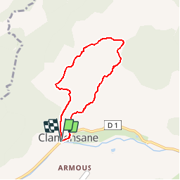
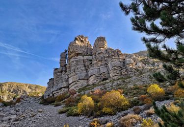
Trail Walking of 5.9 km to be discovered at Provence-Alpes-Côte d'Azur, Alpes-de-Haute-Provence, Clamensane. This trail is proposed by tracegps.
Description
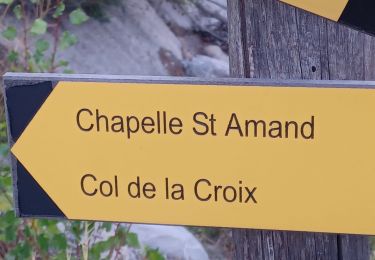
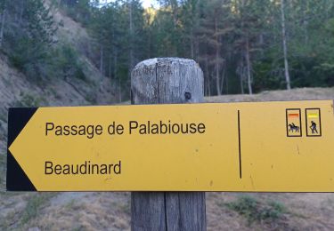
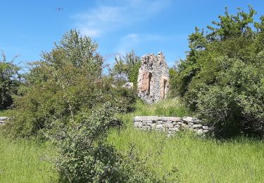
Départ à proximité du pont au Sud-Ouest du village. Le départ de cette jolie boucle démarre au sud ouest du village, à proximité du pont qui enjambe le torrent de Vermeil. Par un court sentier, vous rejoignez la piste qui porte le même nom. 1km plus loin, un magnifique sentier ombragé vous guidera jusqu’à l’aqueduc des Sagnières. Poursuivez votre circuit par une piste jusqu’aux Basses-Graves. Redescendre par cette route goudronnée durant 1km, que vous quitterez sur la droite pour rejoindre Clamensane par le haut du village. Retrouvez le circuit sur le site des Hautes Terres de Provence.
Positioning
Comments
Trails nearby
![Trail Walking Clamensane - Clamensane - Col de la Croix - Chapelle St-Amand - Photo](https://media.geolcdn.com/t/375/260/03bf31a1-ae5a-4bc8-81f0-352f4f7d4b3d.jpg&format=jpg&maxdim=2)
![Walking Walking](https://static1.geolcdn.com/sitytour/trail-icons/101.png)
Walking
![](/images/other/stat-length.png)
![](https://static1.geolcdn.com/siteimages/upload/files/16400158638029165_repeat_loop_refresh_sync_direction_icon.png)
![Trail Walking Valavoire - Sommet de Jouère - Photo](https://media.geolcdn.com/t/375/260/d8443deb-7a4b-44b3-ac6b-fcb5789c326f.jpg&format=jpg&maxdim=2)
![Walking Walking](https://static1.geolcdn.com/sitytour/trail-icons/101.png)
Walking
![](/images/other/stat-length.png)
![](https://static1.geolcdn.com/siteimages/upload/files/16400158638029165_repeat_loop_refresh_sync_direction_icon.png)
![Trail Walking Clamensane - CLAMENSANE. TROU DU DIABLR . CHAPELLE S AMAND . COL LA CROIX . O L M S. IX - Photo](https://media.geolcdn.com/t/375/260/10d9eaa1-fd55-4233-9c4f-5d12e1744ffc.jpg&format=jpg&maxdim=2)
![Walking Walking](https://static1.geolcdn.com/sitytour/trail-icons/101.png)
Walking
![](/images/other/stat-length.png)
![](https://static1.geolcdn.com/siteimages/upload/files/16400158638029165_repeat_loop_refresh_sync_direction_icon.png)
![Trail Walking Clamensane - VALAVOIRE Pas de Palabiouse , bergerie de Premarche o l s - Photo](https://media.geolcdn.com/t/375/260/0c200d5e-0f59-43cc-96e6-d7b8947343f2.jpg&format=jpg&maxdim=2)
![Walking Walking](https://static1.geolcdn.com/sitytour/trail-icons/101.png)
Walking
![](/images/other/stat-length.png)
![](https://static1.geolcdn.com/siteimages/upload/files/16400158638029165_repeat_loop_refresh_sync_direction_icon.png)
![Trail Walking Clamensane - VALAVOIRE. Pas de Palabrouse. Fontaine de Pouille o l s - Photo](https://media.geolcdn.com/t/375/260/d94e99f0-0c27-4f39-bd9c-c7d2b68f013f.jpg&format=jpg&maxdim=2)
![Walking Walking](https://static1.geolcdn.com/sitytour/trail-icons/101.png)
Walking
![](/images/other/stat-length.png)
![](https://static1.geolcdn.com/siteimages/upload/files/16400158638029165_repeat_loop_refresh_sync_direction_icon.png)
![Trail Walking La Motte-du-Caire - LA MOTTE DU CAIRE .Le tour de la Blachere o - Photo](https://media.geolcdn.com/t/375/260/181c511a-92a7-4933-9888-9e2bc6024806.jpg&format=jpg&maxdim=2)
![Walking Walking](https://static1.geolcdn.com/sitytour/trail-icons/101.png)
Walking
![](/images/other/stat-length.png)
![](https://static1.geolcdn.com/siteimages/upload/files/16400158638029165_repeat_loop_refresh_sync_direction_icon.png)
![Trail Walking Valavoire - Château de la mole - Col de la Sapie - Photo](https://media.geolcdn.com/t/375/260/4daf6a52-01d9-480a-9c8c-120e5682afb7.jpg&format=jpg&maxdim=2)
![Walking Walking](https://static1.geolcdn.com/sitytour/trail-icons/101.png)
Walking
![](/images/other/stat-length.png)
![](https://static1.geolcdn.com/siteimages/upload/files/16400158638029165_repeat_loop_refresh_sync_direction_icon.png)
![Trail Walking Nibles - NIBLES . CANAL DU MOULIN . PASSAGE DE L HOMME MORT . S JACQUES O L - Photo](https://media.geolcdn.com/t/375/260/2fa73386-20dc-44c2-aea9-4ca90b12e862.jpg&format=jpg&maxdim=2)
![Walking Walking](https://static1.geolcdn.com/sitytour/trail-icons/101.png)
Walking
![](/images/other/stat-length.png)
![](https://static1.geolcdn.com/siteimages/upload/files/16400158638029165_repeat_loop_refresh_sync_direction_icon.png)
![Trail Walking Clamensane - CLAMENSANE BERGERIE BERGIE ROCHER CHABRIER O S L - Photo](https://media.geolcdn.com/t/375/260/220e1021-cc5e-48e0-8055-b6a13c355da7.jpg&format=jpg&maxdim=2)
![Walking Walking](https://static1.geolcdn.com/sitytour/trail-icons/101.png)
Walking
![](/images/other/stat-length.png)
![](https://static1.geolcdn.com/siteimages/upload/files/16400158638029165_repeat_loop_refresh_sync_direction_icon.png)