![](/images/other/stat-length.png)
![Trail Walking Mirecourt - Sentier des Luthiers - Mirecourt - Photo](https://media.geolcdn.com/t/1900/400/ext.pjpeg?maxdim=2&url=https%3A%2F%2Fservices.sitytrail.com%2FGeolivesWS%2FDownloadMedia.ashx%3FTrailID%3D112780%26Media%3D12361_5.jpg)
Sentier des Luthiers - Mirecourt
tracegps
User
![Length](/images/other/stat-length.png)
Length
2.4 km
![Max alt](https://static1.geolcdn.com/siteimages/upload/files/1508320355ic_sort_altitude_max_24dp.png)
Max alt
283 m
![Uphill gradient](https://static1.geolcdn.com/siteimages/upload/files/1508320355ic_sort_den_pos_24dp.png)
Uphill gradient
26 m
![Km-Effort](/images/other/stat-length.png)
Km-Effort
2.8 km
![Min alt](https://static1.geolcdn.com/siteimages/upload/files/1508320355ic_sort_altitude_min_24dp.png)
Min alt
264 m
![Downhill gradient](https://static1.geolcdn.com/siteimages/upload/files/1508320355ic_sort_den_neg_24dp.png)
Downhill gradient
27 m
![Boucle](https://static1.geolcdn.com/siteimages/upload/files/16400158638029165_repeat_loop_refresh_sync_direction_icon.png)
Boucle
Yes
Creation date :
2014-12-10 00:00:00.0
Updated on :
2014-12-10 00:00:00.0
![Walking](https://static1.geolcdn.com/sitytour/trail-icons/101.png)
40m
Difficulty : Easy
![Scan this QR Code to open this trail in the SityTrail application](https://capi.geolives.com/qq0zvz2zws4bq2lad0pu/sitytour/trails/112780/qr.png?size=200)
FREE GPS app for hiking
About
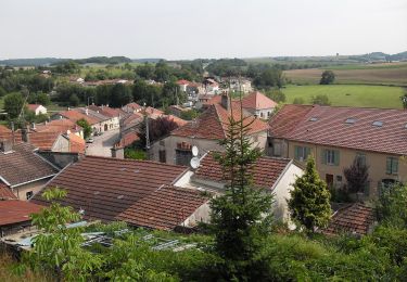
Trail Walking of 2.4 km to be discovered at Grand Est, Vosges, Mirecourt. This trail is proposed by tracegps.
Description
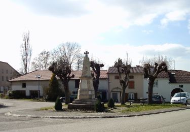
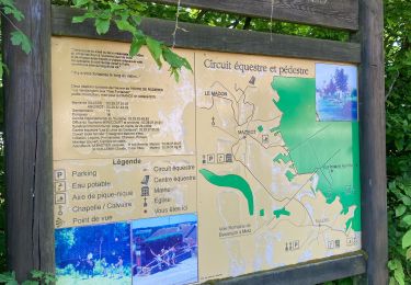
Circuit proposé par la communauté de communes de Mirecourt. Départ de la cour Stanislas devant le musée des Luthiers à Mirecourt. Retrouvez les circuits de la communauté de communes de Mirecourt sur leur site.
Positioning
Country:
France
Region :
Grand Est
Department/Province :
Vosges
Municipality :
Mirecourt
Location:
Unknown
Start:(Dec)
Start:(UTM)
287612 ; 5353802 (32U) N.
Comments
Trails nearby
![Trail On foot Mirecourt - Sentier des Écoliers - Photo](https://media.geolcdn.com/t/375/260/37a85499-65f3-411c-b514-fd76b1c94f58.jpeg&format=jpg&maxdim=2)
![On foot On foot](https://static1.geolcdn.com/sitytour/trail-icons/100.png)
Sentier des Écoliers
On foot
Easy
Mirecourt,
Grand Est,
Vosges,
France
![](/images/other/stat-length.png)
7.3 km | 9.1 km-effort
2h 4min
![](https://static1.geolcdn.com/siteimages/upload/files/16400158638029165_repeat_loop_refresh_sync_direction_icon.png)
Yes
![Trail On foot Mazirot - Sentier des Trois Fontaines - Photo](https://media.geolcdn.com/t/375/260/3195c67f-6fc7-4a51-b3fc-afb10c20cd4c.jpeg&format=jpg&maxdim=2)
![On foot On foot](https://static1.geolcdn.com/sitytour/trail-icons/100.png)
Sentier des Trois Fontaines
On foot
Easy
Mazirot,
Grand Est,
Vosges,
France
![](/images/other/stat-length.png)
10.7 km | 13.1 km-effort
2h 59min
![](https://static1.geolcdn.com/siteimages/upload/files/16400158638029165_repeat_loop_refresh_sync_direction_icon.png)
Yes
![Trail On foot Domvallier - Sentier Victor Hugo - Photo](https://media.geolcdn.com/t/375/260/847969bb-b882-4d7a-93e4-f8a52a5951e6.jpeg&format=jpg&maxdim=2)
![On foot On foot](https://static1.geolcdn.com/sitytour/trail-icons/100.png)
Sentier Victor Hugo
On foot
Easy
Domvallier,
Grand Est,
Vosges,
France
![](/images/other/stat-length.png)
13.8 km | 17.1 km-effort
3h 52min
![](https://static1.geolcdn.com/siteimages/upload/files/16400158638029165_repeat_loop_refresh_sync_direction_icon.png)
Yes
![Trail On foot Mirecourt - Sentier des Luthiers et des Dentellières - Photo](https://media.geolcdn.com/t/375/260/224ec8ee-02f7-4835-910b-c43f2bba21e0.jpeg&format=jpg&maxdim=2)
![On foot On foot](https://static1.geolcdn.com/sitytour/trail-icons/100.png)
Sentier des Luthiers et des Dentellières
On foot
Easy
Mirecourt,
Grand Est,
Vosges,
France
![](/images/other/stat-length.png)
14.6 km | 17.1 km-effort
3h 53min
![](https://static1.geolcdn.com/siteimages/upload/files/16400158638029165_repeat_loop_refresh_sync_direction_icon.png)
Yes
![Trail On foot Puzieux - Sentier Sainte-Menne - Photo](https://media.geolcdn.com/t/375/260/d09aae78-2027-4ee8-af6c-352934fc41fe.jpeg&format=jpg&maxdim=2)
![On foot On foot](https://static1.geolcdn.com/sitytour/trail-icons/100.png)
Sentier Sainte-Menne
On foot
Easy
Puzieux,
Grand Est,
Vosges,
France
![](/images/other/stat-length.png)
12.4 km | 14.1 km-effort
3h 12min
![](https://static1.geolcdn.com/siteimages/upload/files/16400158638029165_repeat_loop_refresh_sync_direction_icon.png)
Yes
![Trail On foot Villers - GR 507 (variante) - Photo](https://media.geolcdn.com/t/375/260/d09aae78-2027-4ee8-af6c-352934fc41fe.jpeg&format=jpg&maxdim=2)
![On foot On foot](https://static1.geolcdn.com/sitytour/trail-icons/100.png)
GR 507 (variante)
On foot
Easy
Villers,
Grand Est,
Vosges,
France
![](/images/other/stat-length.png)
5.6 km | 7.1 km-effort
1h 36min
![](https://static1.geolcdn.com/siteimages/upload/files/16400158638029165_repeat_loop_refresh_sync_direction_icon.png)
No
![Trail sport Mazirot - Sentier des 3 fontaines - Photo](https://media.geolcdn.com/t/375/260/7a6b2516-fa41-4a74-82f6-03130015cbc5.jpg&format=jpg&maxdim=2)
Sentier des 3 fontaines
sport
Very easy
Mazirot,
Grand Est,
Vosges,
France
![](/images/other/stat-length.png)
11.7 km | 14.3 km-effort
Unknown
![](https://static1.geolcdn.com/siteimages/upload/files/16400158638029165_repeat_loop_refresh_sync_direction_icon.png)
Yes
![Trail On foot Mattaincourt - Sentier du bois de Malaumont - Photo](https://media.geolcdn.com/t/375/260/881a2747-b482-491a-9e7a-bbf923a2a0ab.jpeg&format=jpg&maxdim=2)
![On foot On foot](https://static1.geolcdn.com/sitytour/trail-icons/100.png)
Sentier du bois de Malaumont
On foot
Easy
Mattaincourt,
Grand Est,
Vosges,
France
![](/images/other/stat-length.png)
3.5 km | 4.5 km-effort
1h 1min
![](https://static1.geolcdn.com/siteimages/upload/files/16400158638029165_repeat_loop_refresh_sync_direction_icon.png)
Yes
![Trail Walking Mirecourt - Sentier des luthiers et des dentellières - Mirecourt - Photo](https://media.geolcdn.com/t/375/260/ext.jpg?maxdim=2&url=https%3A%2F%2Fservices.sitytrail.com%2FGeolivesWS%2FDownloadMedia.ashx%3FTrailID%3D112764%26Media%3D12113_5.jpg)
![Walking Walking](https://static1.geolcdn.com/sitytour/trail-icons/101.png)
Sentier des luthiers et des dentellières - Mirecourt
Walking
Difficult
Mirecourt,
Grand Est,
Vosges,
France
![](/images/other/stat-length.png)
15 km | 17.7 km-effort
3h 45min
![](https://static1.geolcdn.com/siteimages/upload/files/16400158638029165_repeat_loop_refresh_sync_direction_icon.png)
Yes