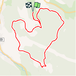
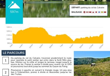
![](/images/other/stat-length.png)
![Trail Walking Plainfaing - Tour du Bramont - Plainfaing - Photo](https://media.geolcdn.com/t/1900/400/ext.pjpeg?maxdim=2&url=https%3A%2F%2Fservices.sitytrail.com%2FGeolivesWS%2FDownloadMedia.ashx%3FTrailID%3D112733%26Media%3D11771_1.jpg)
Tour du Bramont - Plainfaing
tracegps
User
![Length](/images/other/stat-length.png)
![Max alt](https://static1.geolcdn.com/siteimages/upload/files/1508320355ic_sort_altitude_max_24dp.png)
![Uphill gradient](https://static1.geolcdn.com/siteimages/upload/files/1508320355ic_sort_den_pos_24dp.png)
![Km-Effort](/images/other/stat-length.png)
![Min alt](https://static1.geolcdn.com/siteimages/upload/files/1508320355ic_sort_altitude_min_24dp.png)
![Downhill gradient](https://static1.geolcdn.com/siteimages/upload/files/1508320355ic_sort_den_neg_24dp.png)
![Boucle](https://static1.geolcdn.com/siteimages/upload/files/16400158638029165_repeat_loop_refresh_sync_direction_icon.png)
![Walking](https://static1.geolcdn.com/sitytour/trail-icons/101.png)
2h30
Difficulty : Medium
![Scan this QR Code to open this trail in the SityTrail application](https://capi.geolives.com/qq0zvz2zws4bq2lad0pu/sitytour/trails/112733/qr.png?size=200)
FREE GPS app for hiking
About
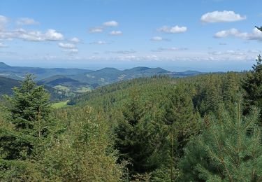
Trail Walking of 10.5 km to be discovered at Grand Est, Vosges, Plainfaing. This trail is proposed by tracegps.
Description
Circuit proposé par l'Office de Tourisme Hautes-Vosges Nature. Par un sentier tout en balcon au dessus de Plainfaing et de ses hameaux, cet agréable circuit vous fera découvrir des pâturages où les agriculteurs travaillent «dur» au maintien des fermes dans nos montagne... Départ de la ferme-auberge des Grands Prés. Accès: 1 km après le centre de Plainfaing sur la N 415 montant en direction du col du Bonhomme. Un chemin part sur la droite, monte vers la ferme-auberge des Grands Prés. Montez à la ferme et garez votre voiture sur le parking. Vous pouvez retrouver le topoguide avec 18 balades au pays de la Haute-Meurthe, pour 2€50, à l'Office de Tourisme Hautes-Vosges Nature.
Positioning
Comments
Trails nearby
![Trail Walking Le Bonhomme - Tête des faux . - Photo](https://media.geolcdn.com/t/375/260/84fec98d-7f8b-4bf8-a434-52c0363ad440.jpg&format=jpg&maxdim=2)
![Walking Walking](https://static1.geolcdn.com/sitytour/trail-icons/101.png)
Walking
![](/images/other/stat-length.png)
![](https://static1.geolcdn.com/siteimages/upload/files/16400158638029165_repeat_loop_refresh_sync_direction_icon.png)
![Trail Mountain bike Orbey - Lac Blanc - Têtes des Faux - Photo](https://media.geolcdn.com/t/375/260/ext.jpg?maxdim=2&url=https%3A%2F%2Fservices.sitytrail.com%2FGeolivesWS%2FDownloadMedia.ashx%3FTrailID%3D101197%26Media%3D684_1.jpg)
![Mountain bike Mountain bike](https://static1.geolcdn.com/sitytour/trail-icons/202.png)
Mountain bike
![](/images/other/stat-length.png)
![](https://static1.geolcdn.com/siteimages/upload/files/16400158638029165_repeat_loop_refresh_sync_direction_icon.png)
![Trail Horseback riding Fraize - suuntoapp-HorsebackRiding-2024-09-22T07-59-41Z - Photo](https://media.geolcdn.com/t/375/260/659ca71d-c8a1-4767-9294-a1d2bab3a6df.jpg&format=jpg&maxdim=2)
![Horseback riding Horseback riding](https://static1.geolcdn.com/sitytour/trail-icons/301.png)
Horseback riding
![](/images/other/stat-length.png)
![](https://static1.geolcdn.com/siteimages/upload/files/16400158638029165_repeat_loop_refresh_sync_direction_icon.png)
![Trail Walking Mandray - Chapelle de mangegoutte - Photo](https://media.geolcdn.com/t/375/260/ext.jpg?maxdim=2&url=https%3A%2F%2Fstatic1.geolcdn.com%2Fsiteimages%2Fupload%2Ffiles%2F1553511878bg_sport_marche.png)
![Walking Walking](https://static1.geolcdn.com/sitytour/trail-icons/101.png)
Walking
![](/images/other/stat-length.png)
![](https://static1.geolcdn.com/siteimages/upload/files/16400158638029165_repeat_loop_refresh_sync_direction_icon.png)
![Trail Horseback riding Ban-sur-Meurthe-Clefcy - Chez Delphine yoigo - Photo](https://media.geolcdn.com/t/375/260/303dc882-106e-4dee-a8f9-ee7934eaab19.jpg&format=jpg&maxdim=2)
![Horseback riding Horseback riding](https://static1.geolcdn.com/sitytour/trail-icons/301.png)
Horseback riding
![](/images/other/stat-length.png)
![](https://static1.geolcdn.com/siteimages/upload/files/16400158638029165_repeat_loop_refresh_sync_direction_icon.png)
![Trail Walking Orbey - Vallée des 5 lacs - Photo](https://media.geolcdn.com/t/375/260/96031f65-b958-4b6d-af19-7cecb860729d.jpg&format=jpg&maxdim=2)
![Walking Walking](https://static1.geolcdn.com/sitytour/trail-icons/101.png)
Walking
![](/images/other/stat-length.png)
![](https://static1.geolcdn.com/siteimages/upload/files/16400158638029165_repeat_loop_refresh_sync_direction_icon.png)
![Trail Walking Orbey - Col du Calvaire ➡️ Lac Blanc - Photo](https://media.geolcdn.com/t/375/260/d45f3e65-0b13-4169-803a-9a82fdb05a2b.jpg&format=jpg&maxdim=2)
![Walking Walking](https://static1.geolcdn.com/sitytour/trail-icons/101.png)
Walking
![](/images/other/stat-length.png)
![](https://static1.geolcdn.com/siteimages/upload/files/16400158638029165_repeat_loop_refresh_sync_direction_icon.png)
![Trail Electric bike Le Bonhomme - Lac blanc col de la schlucht Six fours lac noir - Photo](https://media.geolcdn.com/t/375/260/5114f748-f66d-451b-a007-e5776d8e4296.jpg&format=jpg&maxdim=2)
![Electric bike Electric bike](https://static1.geolcdn.com/sitytour/trail-icons/205.png)
Electric bike
![](/images/other/stat-length.png)
![](https://static1.geolcdn.com/siteimages/upload/files/16400158638029165_repeat_loop_refresh_sync_direction_icon.png)
![Trail Walking Le Bonhomme - 2024-07-24_18h18m55_230110313 - Photo](https://media.geolcdn.com/t/375/260/bcc841ee-2355-4f5f-b080-3ea14fb8fa2e.jpg&format=jpg&maxdim=2)
![Walking Walking](https://static1.geolcdn.com/sitytour/trail-icons/101.png)
Walking
![](/images/other/stat-length.png)
![](https://static1.geolcdn.com/siteimages/upload/files/16400158638029165_repeat_loop_refresh_sync_direction_icon.png)
Lorsque vous arrivez aux 48°8`50,44`` 7°1`25,26`` prenez à gauche rond bleu car le chemin se. perd sous la ligne ht si non très bon circuit