![](/images/other/stat-length.png)
![Trail Walking Gresse-en-Vercors - GTV - Tour du Vercors à pied - Gresse en Vercors - les Nonnières - Photo](https://media.geolcdn.com/t/1900/400/ext.pjpeg?maxdim=2&url=https%3A%2F%2Fservices.sitytrail.com%2FGeolivesWS%2FDownloadMedia.ashx%3FTrailID%3D112636%26Media%3D11312_2.jpg)
GTV - Tour du Vercors à pied - Gresse en Vercors - les Nonnières
tracegps
User
![Length](/images/other/stat-length.png)
![Max alt](https://static1.geolcdn.com/siteimages/upload/files/1508320355ic_sort_altitude_max_24dp.png)
![Uphill gradient](https://static1.geolcdn.com/siteimages/upload/files/1508320355ic_sort_den_pos_24dp.png)
![Km-Effort](/images/other/stat-length.png)
![Min alt](https://static1.geolcdn.com/siteimages/upload/files/1508320355ic_sort_altitude_min_24dp.png)
![Downhill gradient](https://static1.geolcdn.com/siteimages/upload/files/1508320355ic_sort_den_neg_24dp.png)
![Boucle](https://static1.geolcdn.com/siteimages/upload/files/16400158638029165_repeat_loop_refresh_sync_direction_icon.png)
![Walking](https://static1.geolcdn.com/sitytour/trail-icons/101.png)
14h00
Difficulty : Difficult
![Scan this QR Code to open this trail in the SityTrail application](https://capi.geolives.com/qq0zvz2zws4bq2lad0pu/sitytour/trails/112636/qr.png?size=200)
FREE GPS app for hiking
About
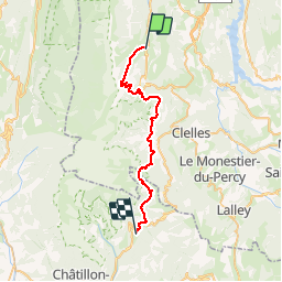
Trail Walking of 32 km to be discovered at Auvergne-Rhône-Alpes, Isère, Gresse-en-Vercors. This trail is proposed by tracegps.
Description
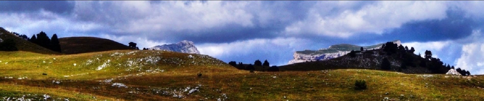
GTV - Tour du Vercors à pied - Gresse en Vercors - les Nonnières Départ du plus haut village du massif (1240m). Attention le balcon Est devient un itinéraire impraticable l’hiver, et très délicat au printemps en raison des coulées de neige. Suivre le balisage jaune-vert jusqu’à la croix de Serre Monet, puis le balisage jaune-rouge jusqu’au champ de l’Herse (sentier central) et à nouveau jaune-vert jusqu’à Chez Cotte, puis jaune-rouge jusqu’au Col des Pellas. Puis une portion qui passe par Trésanne et Chichilianne, deux villages qui ont poussé à l’ombre du Mont Aiguille. Chichilianne abrite un relais d’information du Parc du Vercors. L’itinéraire ne comporte pas de difficulté notable, si ce n’est une bonne montée pour accéder au Pas de l’Essaure. Entre clairières et passages en sous-bois, il emprunte alternativement des sentiers, des chemins et des routes. Le Pas de l’Essaure représente l’une des portes d’entrée vers la Réserve des Hauts Plateaux depuis le Trièves. Puis vous descendez vers les magnifiques prairies du vallon de Combau. Le chemin est toujours bien marqué, mais il n’y a pas de balisage car cette portion se situe dans la Réserve des Hauts Plateaux. Aux granges de Combau, le sentier traverse un bois d’épicéas et de pins à crochets pour déboucher au Col de Côte Chèvre. Panorama exceptionnel ! Tracé officiel labellisé GTV. Le découpage proposé est indicatif et les tronçons ne sont pas imposés. Construisez autour votre propre itinéraire en fonction de votre forme physique et des conditions climatiques. Pour vous aider, consultez les informations de Vercors-GTV.com et retrouvez les itinéraires en détail dans les topo-guides du Parc.
Positioning
Comments
Trails nearby
![Trail Walking Saint-Michel-les-Portes - Grand Ceymont par la face Sud - Photo](https://media.geolcdn.com/t/375/260/d58be866-4722-407f-9e9c-e7428ea96660.jpg&format=jpg&maxdim=2)
![Walking Walking](https://static1.geolcdn.com/sitytour/trail-icons/101.png)
Walking
![](/images/other/stat-length.png)
![](https://static1.geolcdn.com/siteimages/upload/files/16400158638029165_repeat_loop_refresh_sync_direction_icon.png)
![Trail Walking Gresse-en-Vercors - Quinquambaye - crête du Brisou - Photo](https://media.geolcdn.com/t/375/260/686aed71-19ef-4a34-8333-a2b65dd9c4d5.jpg&format=jpg&maxdim=2)
![Walking Walking](https://static1.geolcdn.com/sitytour/trail-icons/101.png)
Walking
![](/images/other/stat-length.png)
![](https://static1.geolcdn.com/siteimages/upload/files/16400158638029165_repeat_loop_refresh_sync_direction_icon.png)
![Trail Walking Gresse-en-Vercors - Traversée du Rocher du Baconnet - Photo](https://media.geolcdn.com/t/375/260/ext.jpg?maxdim=2&url=https%3A%2F%2Fservices.sitytrail.com%2FGeolivesWS%2FDownloadMedia.ashx%3FTrailID%3D105962%26Media%3D10040_1.jpg)
![Walking Walking](https://static1.geolcdn.com/sitytour/trail-icons/101.png)
Walking
![](/images/other/stat-length.png)
![](https://static1.geolcdn.com/siteimages/upload/files/16400158638029165_repeat_loop_refresh_sync_direction_icon.png)
![Trail Walking Saint-Michel-les-Portes - Tour du Mont Aiguille - Photo](https://media.geolcdn.com/t/375/260/13641da4-549e-49b9-8e23-d4a17f7e4345.jpg&format=jpg&maxdim=2)
![Walking Walking](https://static1.geolcdn.com/sitytour/trail-icons/101.png)
Walking
![](/images/other/stat-length.png)
![](https://static1.geolcdn.com/siteimages/upload/files/16400158638029165_repeat_loop_refresh_sync_direction_icon.png)
![Trail Walking Gresse-en-Vercors - le grand veymont depuis gresse en vercors et par le pas de la ville - Photo](https://media.geolcdn.com/t/375/260/ext.jpg?maxdim=2&url=https%3A%2F%2Fstatic1.geolcdn.com%2Fsiteimages%2Fupload%2Ffiles%2F1553511878bg_sport_marche.png)
![Walking Walking](https://static1.geolcdn.com/sitytour/trail-icons/101.png)
Walking
![](/images/other/stat-length.png)
![](https://static1.geolcdn.com/siteimages/upload/files/16400158638029165_repeat_loop_refresh_sync_direction_icon.png)
![Trail Walking Saint-Michel-les-Portes - Pas de Bachassons et de la Selle - Photo](https://media.geolcdn.com/t/375/260/10e42988-cabf-4bc0-8c6b-1118178d695b.jpg&format=jpg&maxdim=2)
![Walking Walking](https://static1.geolcdn.com/sitytour/trail-icons/101.png)
Walking
![](/images/other/stat-length.png)
![](https://static1.geolcdn.com/siteimages/upload/files/16400158638029165_repeat_loop_refresh_sync_direction_icon.png)
![Trail Walking Gresse-en-Vercors - Pas de Serpaton et crêtes, de Gresse en Vercors - Photo](https://media.geolcdn.com/t/375/260/184f68f2-62ff-4093-8bd0-69314b118936.jpg&format=jpg&maxdim=2)
![Walking Walking](https://static1.geolcdn.com/sitytour/trail-icons/101.png)
Walking
![](/images/other/stat-length.png)
![](https://static1.geolcdn.com/siteimages/upload/files/16400158638029165_repeat_loop_refresh_sync_direction_icon.png)
![Trail Walking Gresse-en-Vercors - Grand Veymond de Gresse en Vercors - Photo](https://media.geolcdn.com/t/375/260/2232aaa5-57f5-4754-96ce-b8c8c04af563.jpg&format=jpg&maxdim=2)
![Walking Walking](https://static1.geolcdn.com/sitytour/trail-icons/101.png)
Walking
![](/images/other/stat-length.png)
![](https://static1.geolcdn.com/siteimages/upload/files/16400158638029165_repeat_loop_refresh_sync_direction_icon.png)
![Trail Walking Gresse-en-Vercors - Le grand veymont 2341 m - Photo](https://media.geolcdn.com/t/375/260/1c0de7b0-54c4-46b0-a110-3cbad7cf7845.jpg&format=jpg&maxdim=2)
![Walking Walking](https://static1.geolcdn.com/sitytour/trail-icons/101.png)
Walking
![](/images/other/stat-length.png)
![](https://static1.geolcdn.com/siteimages/upload/files/16400158638029165_repeat_loop_refresh_sync_direction_icon.png)