Trail Cycle Mailly-le-Camp - La Plaine Champenoise - Mailly le Camp - Photo

La Plaine Champenoise - Mailly le Camp

 tracegps
tracegps

User

© OpenStreetMap contributors
Length
Length
66 km
Max alt
Max alt
164 m
Uphill gradient
Uphill gradient
343 m
Km-Effort
Km-Effort  
71 km
Min alt
Min alt
79 m
Downhill gradient
Downhill gradient
345 m
Boucle
Boucle
Yes
Creation date :
2014-12-10 00:00:00.0
Updated on :
2014-12-10 00:00:00.0

(0 Reviews)

Cycle
Cycle
2h30
Difficulty : Medium

Scan this QR Code to open this trail in the SityTrail application

FREE GPS app for hiking

Logo SityTrail SityTrail

IGN / Geographical institutes

Download SityTrail from the App Store Download SityTrail from Google Play

Logo SityTrail SityTrail World

The world is yours!

Download SityTrail from the App Store Download SityTrail from Google Play Download SityTrail on Huawei AppGallery

About

Trail Cycle of 66 km to be discovered at Grand Est, Aube, Mailly-le-Camp. This trail is proposed by tracegps.

Description

Proposé par le Comité Départemental du Tourisme de l'Aube, un circuit créé et validé par la Fédération Départementale du Cyclotourisme de l’Aube. La Plaine Champenoise – 65 km - Église Sainte Tanche de Lhuître - Vallée de l’Aube - Église Saint-Etienne d’Arcis-sur-Aube

Elevation profile

Photos

Points of interest

Point of interest Mailly-le-Camp - cycloguide N?14 La Plaine Champenoise 66.174 km - Photo
tracegps

Positioning

Country:
France
Region :
Grand Est
Department/Province :
Aube
Municipality :
Mailly-le-Camp
Location:
Unknown
Start:(Dec)
Start:(UTM)
587701 ; 5392006 (31U) N.

Trails nearby

Trail Cycle Mailly-le-Camp - de Mailly-le-camp à chelles - Photo
Cycle
destras

Cycle

Medium
Mailly-le-Camp, Grand Est, Aube, France
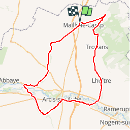
139 km | 156 km-effort
6h 40min
No


Close
My subscriptions