![](/images/other/stat-length.png)
![Trail Cycle Bayel - Terre des Grands Hommes - Photo](https://media.geolcdn.com/t/1900/400/ext.pjpeg?maxdim=2&url=https%3A%2F%2Fservices.sitytrail.com%2FGeolivesWS%2FDownloadMedia.ashx%3FTrailID%3D112583%26Media%3D11030_1.jpg)
Terre des Grands Hommes
tracegps
User
![Length](/images/other/stat-length.png)
![Max alt](https://static1.geolcdn.com/siteimages/upload/files/1508320355ic_sort_altitude_max_24dp.png)
![Uphill gradient](https://static1.geolcdn.com/siteimages/upload/files/1508320355ic_sort_den_pos_24dp.png)
![Km-Effort](/images/other/stat-length.png)
![Min alt](https://static1.geolcdn.com/siteimages/upload/files/1508320355ic_sort_altitude_min_24dp.png)
![Downhill gradient](https://static1.geolcdn.com/siteimages/upload/files/1508320355ic_sort_den_neg_24dp.png)
![Boucle](https://static1.geolcdn.com/siteimages/upload/files/16400158638029165_repeat_loop_refresh_sync_direction_icon.png)
![Cycle](https://static1.geolcdn.com/sitytour/trail-icons/200.png)
3h00
Difficulty : Medium
![Scan this QR Code to open this trail in the SityTrail application](https://capi.geolives.com/qq0zvz2zws4bq2lad0pu/sitytour/trails/112583/qr.png?size=200)
FREE GPS app for hiking
About
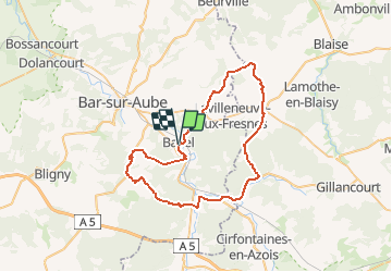
Trail Cycle of 53 km to be discovered at Grand Est, Aube, Bayel. This trail is proposed by tracegps.
Description
Proposé par le Comité Départemental du Tourisme de l'Aube, un circuit créé et validé par la Fédération Départementale du Cyclotourisme de l’Aube. Terre des Grands Hommes – 52 km – Niveau Moyen A voir lors de votre circuit : - Cristallerie royale de Champagne à Bayel - Abbaye cistercienne de Clairvaux XIIème siècle - Musée et Mémorial Charles-de-Gaulle à Colombey les 2 Eglises - Caves de champagne - Eglises d’Arconville et de Bayel A proximité : Château de Cirey sur Blaise – fleuristerie d’Orge
Positioning
Comments
Trails nearby
![Trail Walking Longchamp-sur-Aujon - château de la sue - Photo](https://media.geolcdn.com/t/375/260/ext.jpg?maxdim=2&url=https%3A%2F%2Fstatic1.geolcdn.com%2Fsiteimages%2Fupload%2Ffiles%2F1553511878bg_sport_marche.png)
![Walking Walking](https://static1.geolcdn.com/sitytour/trail-icons/101.png)
Walking
![](/images/other/stat-length.png)
![](https://static1.geolcdn.com/siteimages/upload/files/16400158638029165_repeat_loop_refresh_sync_direction_icon.png)
Parcours très agréable. Cependant il faudrait préciser qu'à 2km de l'arrivée le parcours emprunté un chemin forestier.