![](/images/other/stat-length.png)
![Trail Walking Vernon - Les Carrières - Vernon - Photo](https://media.geolcdn.com/t/1900/400/ext.pjpeg?maxdim=2&url=https%3A%2F%2Fservices.sitytrail.com%2FGeolivesWS%2FDownloadMedia.ashx%3FTrailID%3D112574%26Media%3D10989_5.jpg)
Les Carrières - Vernon
tracegps
User
![Length](/images/other/stat-length.png)
Length
4 km
![Max alt](https://static1.geolcdn.com/siteimages/upload/files/1508320355ic_sort_altitude_max_24dp.png)
Max alt
127 m
![Uphill gradient](https://static1.geolcdn.com/siteimages/upload/files/1508320355ic_sort_den_pos_24dp.png)
Uphill gradient
101 m
![Km-Effort](/images/other/stat-length.png)
Km-Effort
5.4 km
![Min alt](https://static1.geolcdn.com/siteimages/upload/files/1508320355ic_sort_altitude_min_24dp.png)
Min alt
17 m
![Downhill gradient](https://static1.geolcdn.com/siteimages/upload/files/1508320355ic_sort_den_neg_24dp.png)
Downhill gradient
101 m
![Boucle](https://static1.geolcdn.com/siteimages/upload/files/16400158638029165_repeat_loop_refresh_sync_direction_icon.png)
Boucle
Yes
Creation date :
2014-12-10 00:00:00.0
Updated on :
2014-12-10 00:00:00.0
![Walking](https://static1.geolcdn.com/sitytour/trail-icons/101.png)
1h00
Difficulty : Easy
![Scan this QR Code to open this trail in the SityTrail application](https://capi.geolives.com/qq0zvz2zws4bq2lad0pu/sitytour/trails/112574/qr.png?size=200)
FREE GPS app for hiking
About
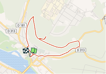
Trail Walking of 4 km to be discovered at Normandy, Eure, Vernon. This trail is proposed by tracegps.
Description
Circuit proposé par la commune de Vernon. Départ du château des Tourelles. Circuit de difficulté moyenne et accessible aux VTT non débutants. Avant de partir ou au retour, visitez le Parc du Château des Tourelles et admirez le Vieux Moulin. Retrouvez les circuits de Vernon sur le site de Vernon.
Positioning
Country:
France
Region :
Normandy
Department/Province :
Eure
Municipality :
Vernon
Location:
Unknown
Start:(Dec)
Start:(UTM)
389703 ; 5439482 (31U) N.
Comments
Trails nearby
![Trail Walking Vernon - Les falaises de Seine de Vernon à Mantes la Jolie - Photo](https://media.geolcdn.com/t/375/260/5fb6d91d-220e-4b46-8986-f386f1d9411e.jpg&format=jpg&maxdim=2)
![Walking Walking](https://static1.geolcdn.com/sitytour/trail-icons/101.png)
Les falaises de Seine de Vernon à Mantes la Jolie
Walking
Difficult
Vernon,
Normandy,
Eure,
France
![](/images/other/stat-length.png)
37 km | 47 km-effort
7h 38min
![](https://static1.geolcdn.com/siteimages/upload/files/16400158638029165_repeat_loop_refresh_sync_direction_icon.png)
No
![Trail Walking Giverny - 076-104-Giverny Matin 12km-526-030- - Photo](https://media.geolcdn.com/t/375/260/2efe6bca-4705-4852-8c25-252c9af261ae.jpg&format=jpg&maxdim=2)
![Walking Walking](https://static1.geolcdn.com/sitytour/trail-icons/101.png)
076-104-Giverny Matin 12km-526-030-
Walking
Easy
(2)
Giverny,
Normandy,
Eure,
France
![](/images/other/stat-length.png)
9.2 km | 11.5 km-effort
2h 32min
![](https://static1.geolcdn.com/siteimages/upload/files/16400158638029165_repeat_loop_refresh_sync_direction_icon.png)
Yes
![Trail Walking La Chapelle-Longueville - Saint Just - Les coteaux de Seine - Photo](https://media.geolcdn.com/t/375/260/ext.jpg?maxdim=2&url=https%3A%2F%2Fstatic1.geolcdn.com%2Fsiteimages%2Fupload%2Ffiles%2F1553511878bg_sport_marche.png)
![Walking Walking](https://static1.geolcdn.com/sitytour/trail-icons/101.png)
Saint Just - Les coteaux de Seine
Walking
Easy
(4)
La Chapelle-Longueville,
Normandy,
Eure,
France
![](/images/other/stat-length.png)
10.5 km | 13.8 km-effort
2h 57min
![](https://static1.geolcdn.com/siteimages/upload/files/16400158638029165_repeat_loop_refresh_sync_direction_icon.png)
Yes
![Trail Walking Giverny - Giverny Le lézard vert - Photo](https://media.geolcdn.com/t/375/260/b5c62cc3-3474-47fb-9b85-16cd33879457.jpg&format=jpg&maxdim=2)
![Walking Walking](https://static1.geolcdn.com/sitytour/trail-icons/101.png)
Giverny Le lézard vert
Walking
Difficult
Giverny,
Normandy,
Eure,
France
![](/images/other/stat-length.png)
5.7 km | 7.5 km-effort
1h 57min
![](https://static1.geolcdn.com/siteimages/upload/files/16400158638029165_repeat_loop_refresh_sync_direction_icon.png)
No
![Trail Walking Giverny - Giverny : les coteaux vers le Vexin 13 km - Photo](https://media.geolcdn.com/t/375/260/c82fb9e5-5a3f-476d-97d5-3fb681dd4a31.jpg&format=jpg&maxdim=2)
![Walking Walking](https://static1.geolcdn.com/sitytour/trail-icons/101.png)
Giverny : les coteaux vers le Vexin 13 km
Walking
Very easy
Giverny,
Normandy,
Eure,
France
![](/images/other/stat-length.png)
14.7 km | 17.8 km-effort
4h 51min
![](https://static1.geolcdn.com/siteimages/upload/files/16400158638029165_repeat_loop_refresh_sync_direction_icon.png)
No
![Trail Motor Giverny - Giverny , les Coteaux avril 2019 - Photo](https://media.geolcdn.com/t/375/260/ext.jpg?maxdim=2&url=https%3A%2F%2Fservices.sitytrail.com%2FGeolivesWS%2FDownloadMedia.ashx%3FTrailID%3D1143131%26Media%3Dfix__20190408160534.jpg)
![Motor Motor](https://static1.geolcdn.com/sitytour/trail-icons/400.png)
Giverny , les Coteaux avril 2019
Motor
Medium
Giverny,
Normandy,
Eure,
France
![](/images/other/stat-length.png)
13.6 km | 16.5 km-effort
3h 28min
![](https://static1.geolcdn.com/siteimages/upload/files/16400158638029165_repeat_loop_refresh_sync_direction_icon.png)
No
![Trail Motor Giverny - Giverny , les Coteaux avril 2019 - Photo](https://media.geolcdn.com/t/375/260/ext.jpg?maxdim=2&url=https%3A%2F%2Fservices.sitytrail.com%2FGeolivesWS%2FDownloadMedia.ashx%3FTrailID%3D1134663%26Media%3Dfix__20190408160534.jpg)
![Motor Motor](https://static1.geolcdn.com/sitytour/trail-icons/400.png)
Giverny , les Coteaux avril 2019
Motor
Medium
Giverny,
Normandy,
Eure,
France
![](/images/other/stat-length.png)
13.6 km | 16.5 km-effort
3h 28min
![](https://static1.geolcdn.com/siteimages/upload/files/16400158638029165_repeat_loop_refresh_sync_direction_icon.png)
No
![Trail Motor Giverny - Giverny , les Coteaux avril 2019 - Photo](https://media.geolcdn.com/t/375/260/ext.jpg?maxdim=2&url=https%3A%2F%2Fservices.sitytrail.com%2FGeolivesWS%2FDownloadMedia.ashx%3FTrailID%3D1132418%26Media%3Dfix__20190408160534.jpg)
![Motor Motor](https://static1.geolcdn.com/sitytour/trail-icons/400.png)
Giverny , les Coteaux avril 2019
Motor
Medium
Giverny,
Normandy,
Eure,
France
![](/images/other/stat-length.png)
13.6 km | 16.5 km-effort
3h 28min
![](https://static1.geolcdn.com/siteimages/upload/files/16400158638029165_repeat_loop_refresh_sync_direction_icon.png)
No
![Trail Mountain bike Vernon - Les prés de Vernonnet - Vernon - Photo](https://media.geolcdn.com/t/375/260/ext.jpg?maxdim=2&url=https%3A%2F%2Fservices.sitytrail.com%2FGeolivesWS%2FDownloadMedia.ashx%3FTrailID%3D112611%26Media%3D11135_5.jpg)
![Mountain bike Mountain bike](https://static1.geolcdn.com/sitytour/trail-icons/202.png)
Les prés de Vernonnet - Vernon
Mountain bike
Easy
Vernon,
Normandy,
Eure,
France
![](/images/other/stat-length.png)
3.3 km | 3.7 km-effort
19min
![](https://static1.geolcdn.com/siteimages/upload/files/16400158638029165_repeat_loop_refresh_sync_direction_icon.png)
Yes