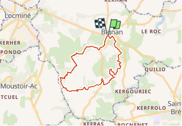
![](/images/other/stat-length.png)
![Trail Walking Bignan - Sentier des landes - Bignan - Photo](https://media.geolcdn.com/t/1900/400/ext.pjpeg?maxdim=2&url=https%3A%2F%2Fstatic1.geolcdn.com%2Fsiteimages%2Fupload%2Ffiles%2F1553511878bg_sport_marche.png)
Sentier des landes - Bignan
tracegps
User
![Length](/images/other/stat-length.png)
![Max alt](https://static1.geolcdn.com/siteimages/upload/files/1508320355ic_sort_altitude_max_24dp.png)
![Uphill gradient](https://static1.geolcdn.com/siteimages/upload/files/1508320355ic_sort_den_pos_24dp.png)
![Km-Effort](/images/other/stat-length.png)
![Min alt](https://static1.geolcdn.com/siteimages/upload/files/1508320355ic_sort_altitude_min_24dp.png)
![Downhill gradient](https://static1.geolcdn.com/siteimages/upload/files/1508320355ic_sort_den_neg_24dp.png)
![Boucle](https://static1.geolcdn.com/siteimages/upload/files/16400158638029165_repeat_loop_refresh_sync_direction_icon.png)
![Walking](https://static1.geolcdn.com/sitytour/trail-icons/101.png)
4h00
Difficulty : Difficult
![Scan this QR Code to open this trail in the SityTrail application](https://capi.geolives.com/qq0zvz2zws4bq2lad0pu/sitytour/trails/112541/qr.png?size=200)
FREE GPS app for hiking
About
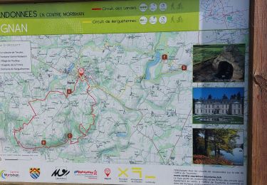
Trail Walking of 13.1 km to be discovered at Brittany, Morbihan, Bignan. This trail is proposed by tracegps.
Description
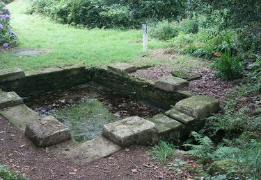
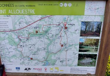
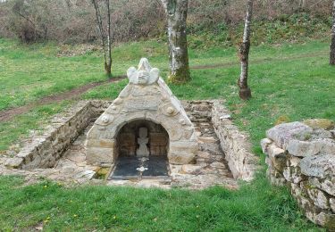
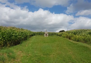
Point de départ ; Salle des Sports de Bignan (rue Yves Le Thieis, près du Calvaire) - (coordonnées GPS : 02° 46’ 15’’ O / 47° 52’ 41’’ N) - Distance : 14 km (4h) A voir en chemin: Le calvaire de Treuliec : c’est une jolie croix en forme de trèfle à quatre feuilles. Elle est du XVIème siècle (1583) et est classée aux monuments historiques. Ce calvaire, qui représente la crucifixion d’un côté et la descente de croix de l’autre, a été restauré cette année 2010 par M. Floch. La fontaine Sainte Noyale : elle était totalement enfouie sous les ronces, la terre, les gravas… et complètement désintégrée. Une équipe de jeunes et de gens du secteur l’a remise en état, il y a une trentaine d’années. Une association s’occupe désormais de cet espace. Sainte Noyale (ou Sainte Nolwenn), selon la légende, venant du pays de Galles, arriva au Bézo. Refusant un certain Nizan, amoureux d’elle, Noyale eut la tête coupée par ce personnage. La fontaine serait le jaillissement de son sang ! Le village de Poublay : situé à contre pente, non loin du terrain de motocross, ce village est constitué de maisons anciennes en pierre.
Positioning
Comments
Trails nearby
![Trail Walking Saint-Jean-Brévelay - Circuit du Carado - Saint Jean Brévelay - Photo](https://media.geolcdn.com/t/375/260/ext.jpg?maxdim=2&url=https%3A%2F%2Fstatic1.geolcdn.com%2Fsiteimages%2Fupload%2Ffiles%2F1553511878bg_sport_marche.png)
![Walking Walking](https://static1.geolcdn.com/sitytour/trail-icons/101.png)
Walking
![](/images/other/stat-length.png)
![](https://static1.geolcdn.com/siteimages/upload/files/16400158638029165_repeat_loop_refresh_sync_direction_icon.png)
![Trail Walking Moustoir-Ac - PR_56_Moustoir-Ac_BA_02_Circuit1b_Des-Cretes_20240724 - Photo](https://media.geolcdn.com/t/375/260/9e6aa16e-42a2-4de2-9a77-dc547244deff.jpg&format=jpg&maxdim=2)
![Walking Walking](https://static1.geolcdn.com/sitytour/trail-icons/101.png)
Walking
![](/images/other/stat-length.png)
![](https://static1.geolcdn.com/siteimages/upload/files/16400158638029165_repeat_loop_refresh_sync_direction_icon.png)
![Trail Walking Saint-Allouestre - PR_56_St-Allouestre_AA_01_Circuit1b_De-La-Lande-Justice_20240326 - Photo](https://media.geolcdn.com/t/375/260/a231c566-4f90-44a1-a1f6-f3bde377255e.jpg&format=jpg&maxdim=2)
![Walking Walking](https://static1.geolcdn.com/sitytour/trail-icons/101.png)
Walking
![](/images/other/stat-length.png)
![](https://static1.geolcdn.com/siteimages/upload/files/16400158638029165_repeat_loop_refresh_sync_direction_icon.png)
![Trail Walking Bignan - PR_56_Bignan_BA_02_Circuit1b_De-Kerguehennec_20231007 - Photo](https://media.geolcdn.com/t/375/260/fdb71b49-38a1-40cc-b7bd-76b1449d177e.jpg&format=jpg&maxdim=2)
![Walking Walking](https://static1.geolcdn.com/sitytour/trail-icons/101.png)
Walking
![](/images/other/stat-length.png)
![](https://static1.geolcdn.com/siteimages/upload/files/16400158638029165_repeat_loop_refresh_sync_direction_icon.png)
![Trail Walking Bignan - Circuit n°56 de Kerguéhennec - Photo](https://media.geolcdn.com/t/375/260/ae25770b-5f0a-4b8f-aa2f-9bff1cdfbaab.jpg&format=jpg&maxdim=2)
![Walking Walking](https://static1.geolcdn.com/sitytour/trail-icons/101.png)
Walking
![](/images/other/stat-length.png)
![](https://static1.geolcdn.com/siteimages/upload/files/16400158638029165_repeat_loop_refresh_sync_direction_icon.png)
![Trail Walking Bignan - PR_56_Bignan_AA_01_Circuit1b_Des-Landes_20230405 - Photo](https://media.geolcdn.com/t/375/260/4c3fd8ab-a849-4bb7-860c-7a48fe42f33e.jpg&format=jpg&maxdim=2)
![Walking Walking](https://static1.geolcdn.com/sitytour/trail-icons/101.png)
Walking
![](/images/other/stat-length.png)
![](https://static1.geolcdn.com/siteimages/upload/files/16400158638029165_repeat_loop_refresh_sync_direction_icon.png)
![Trail Walking Saint-Jean-Brévelay - PR_56_St-Jean-Brevelay_AA_01_Circuit1b_Du-Carado_20190901 - Photo](https://media.geolcdn.com/t/375/260/481c6017-952d-490e-81bf-aaa89cc5d295.jpg&format=jpg&maxdim=2)
![Walking Walking](https://static1.geolcdn.com/sitytour/trail-icons/101.png)
Walking
![](/images/other/stat-length.png)
![](https://static1.geolcdn.com/siteimages/upload/files/16400158638029165_repeat_loop_refresh_sync_direction_icon.png)
![Trail Walking Saint-Allouestre - CA 20191114 MATIN KERGUEHENNEC - Photo](https://media.geolcdn.com/t/375/260/c1e8fe48-66c9-48e8-b867-b3caecf451c7.jpg&format=jpg&maxdim=2)
![Walking Walking](https://static1.geolcdn.com/sitytour/trail-icons/101.png)
Walking
![](/images/other/stat-length.png)
![](https://static1.geolcdn.com/siteimages/upload/files/16400158638029165_repeat_loop_refresh_sync_direction_icon.png)
![Trail Walking Locminé - PR_56_Locmine_AA_01_Circuit1b_Du-Tarun_20190818 - Photo](https://media.geolcdn.com/t/375/260/80e9e0ed-1399-4d77-9a71-1f0c22519a8a.jpg&format=jpg&maxdim=2)
![Walking Walking](https://static1.geolcdn.com/sitytour/trail-icons/101.png)
Walking
![](/images/other/stat-length.png)
![](https://static1.geolcdn.com/siteimages/upload/files/16400158638029165_repeat_loop_refresh_sync_direction_icon.png)