![](/images/other/stat-length.png)
![Trail Walking Paimpont - Vallées et bois du Rauco - Campénéac - Photo](https://media.geolcdn.com/t/1900/400/ext.pjpeg?maxdim=2&url=https%3A%2F%2Fstatic1.geolcdn.com%2Fsiteimages%2Fupload%2Ffiles%2F1553511878bg_sport_marche.png)
Vallées et bois du Rauco - Campénéac
tracegps
User
![Length](/images/other/stat-length.png)
![Max alt](https://static1.geolcdn.com/siteimages/upload/files/1508320355ic_sort_altitude_max_24dp.png)
![Uphill gradient](https://static1.geolcdn.com/siteimages/upload/files/1508320355ic_sort_den_pos_24dp.png)
![Km-Effort](/images/other/stat-length.png)
![Min alt](https://static1.geolcdn.com/siteimages/upload/files/1508320355ic_sort_altitude_min_24dp.png)
![Downhill gradient](https://static1.geolcdn.com/siteimages/upload/files/1508320355ic_sort_den_neg_24dp.png)
![Boucle](https://static1.geolcdn.com/siteimages/upload/files/16400158638029165_repeat_loop_refresh_sync_direction_icon.png)
![Walking](https://static1.geolcdn.com/sitytour/trail-icons/101.png)
3h30
Difficulty : Medium
![Scan this QR Code to open this trail in the SityTrail application](https://capi.geolives.com/qq0zvz2zws4bq2lad0pu/sitytour/trails/112536/qr.png?size=200)
FREE GPS app for hiking
About
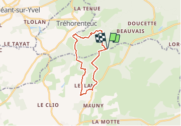
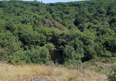
Trail Walking of 10.4 km to be discovered at Brittany, Ille-et-Vilaine, Paimpont. This trail is proposed by tracegps.
Description
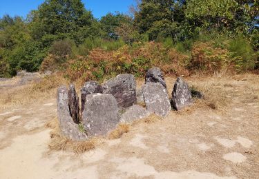
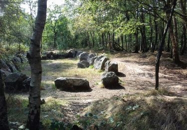
Point de départ : Parking de la Touche Guérin (à Campénéac, prendre direction château de Trécésson puis après la chapelle St Jean vers l’Hotié de Viviane) - Coordonnées GPS : 02°16’01’’O / 47°59’42’’N - Distance : 11 km - 3 h 30 A voir en chemin: 1. Le château de Trécesson (Privé) : bâti à la fin du 15è siècle par Jean de Trécesson, connétable de Bretagne, il garde le souvenir tragique de cette mariée, enlevée de son carrosse par deux gentilshommes masqués et enterrée vivante dans le jardin du château. 2. L’arbre d’or : situé à l’entrée du Val sans Retour, il y a été implanté en 1991 suite à l’incendie qui a ravagé près de 500 hectares de la forêt en septembre 1990. Oeuvre de Francois Davin, ce châtaignier doré à la feuille d’or symbolise la fragilité de la forêt face au risque d’incendie, la renaissance de la nature ainsi que la bêtise humaine qui est très souvent à l’origine des catastrophes naturelles. 3. Le Val sans Retour fait partie des sites les plus reconnus et les plus magiques de la forêt de Brocéliande. Les paysages que l’on y rencontre et l’atmosphère qui y règne transparaissent parfaitement le caractère merveilleux de Brocéliande. Le nom de ce site reflète bien le mystère planant en Brocéliande, cette vallée est en effet le domaine de la Fée Morgane qui y enferme les chevaliers infidèles… 4. L’hôtié de Viviane ou «tombeau des druides» (2500 ans av. JC) : monument mégalithique ayant la forme d’un coffre, cette sépulture contenait du matériel intéressant, attestant de l’existence d’une agriculture dans la région de Paimpont vers 1200 av. JC. Contact: Office de tourisme de Ploërmel « Terres de légendes ». Tel : 02 97 74 02 70 - Email : accueil (at) tourisme-ploermel.com
Positioning
Comments
Trails nearby
![Trail Horseback riding Néant-sur-Yvel - Broceliande - Photo](https://media.geolcdn.com/t/375/260/203abf06-19c3-4c8f-9ce2-990712cb0787.jpg&format=jpg&maxdim=2)
![Horseback riding Horseback riding](https://static1.geolcdn.com/sitytour/trail-icons/301.png)
Horseback riding
![](/images/other/stat-length.png)
![](https://static1.geolcdn.com/siteimages/upload/files/16400158638029165_repeat_loop_refresh_sync_direction_icon.png)
![Trail Walking Campénéac - Château de TRECESSON - Tombeau du Géant - L'Hotié de la Fée Viviane - (8/2019) - Photo](https://media.geolcdn.com/t/375/260/6dc55585-1341-4962-8006-32206bea207b.jpg&format=jpg&maxdim=2)
![Walking Walking](https://static1.geolcdn.com/sitytour/trail-icons/101.png)
Walking
![](/images/other/stat-length.png)
![](https://static1.geolcdn.com/siteimages/upload/files/16400158638029165_repeat_loop_refresh_sync_direction_icon.png)
![Trail Walking Tréhorenteuc - les landes de Gurwant et le Val sans retour - Photo](https://media.geolcdn.com/t/375/260/8ebdb65c-0df1-4e76-a908-0321b1ff5945.jpg&format=jpg&maxdim=2)
![Walking Walking](https://static1.geolcdn.com/sitytour/trail-icons/101.png)
Walking
![](/images/other/stat-length.png)
![](https://static1.geolcdn.com/siteimages/upload/files/16400158638029165_repeat_loop_refresh_sync_direction_icon.png)
![Trail Walking Tréhorenteuc - Tréhorenteuc - Photo](https://media.geolcdn.com/t/375/260/d78e64c2-e4c4-446d-80e9-2d94e7737353.jpg&format=jpg&maxdim=2)
![Walking Walking](https://static1.geolcdn.com/sitytour/trail-icons/101.png)
![Trail Walking Paimpont - GR_37_CE_39_Paimpont_Mauron_20220924 - Photo](https://media.geolcdn.com/t/375/260/d0e9fad4-0af6-4e10-b643-661a6c1313a8.jpg&format=jpg&maxdim=2)
![Walking Walking](https://static1.geolcdn.com/sitytour/trail-icons/101.png)
Walking
![](/images/other/stat-length.png)
![](https://static1.geolcdn.com/siteimages/upload/files/16400158638029165_repeat_loop_refresh_sync_direction_icon.png)
![Trail Walking Tréhorenteuc - Broceliande - Photo](https://media.geolcdn.com/t/375/260/81018fdd-76b5-4b1a-8652-c9a532731623.jpg&format=jpg&maxdim=2)
![Walking Walking](https://static1.geolcdn.com/sitytour/trail-icons/101.png)
Walking
![](/images/other/stat-length.png)
![](https://static1.geolcdn.com/siteimages/upload/files/16400158638029165_repeat_loop_refresh_sync_direction_icon.png)
![Trail On foot Campénéac - Les Landes de Gurwan - Photo](https://media.geolcdn.com/t/375/260/b737382d-2b17-4f2d-90a4-5777864a81d4.jpeg&format=jpg&maxdim=2)
![On foot On foot](https://static1.geolcdn.com/sitytour/trail-icons/100.png)
On foot
![](/images/other/stat-length.png)
![](https://static1.geolcdn.com/siteimages/upload/files/16400158638029165_repeat_loop_refresh_sync_direction_icon.png)
![Trail Walking Néant-sur-Yvel - TUMULUS DU JARDIN AUX MOINES (9/20) - Photo](https://media.geolcdn.com/t/375/260/7bb9903b-d90a-4ad2-bb6c-2c00df8bd974.jpg&format=jpg&maxdim=2)
![Walking Walking](https://static1.geolcdn.com/sitytour/trail-icons/101.png)
Walking
![](/images/other/stat-length.png)
![](https://static1.geolcdn.com/siteimages/upload/files/16400158638029165_repeat_loop_refresh_sync_direction_icon.png)
![Trail Walking Néant-sur-Yvel - Autour des étangs à partir du gîte de tante Phonsine - Photo](https://media.geolcdn.com/t/375/260/c9087903-e076-4035-95d3-8fbe645b66c6.jpg&format=jpg&maxdim=2)
![Walking Walking](https://static1.geolcdn.com/sitytour/trail-icons/101.png)
Walking
![](/images/other/stat-length.png)
![](https://static1.geolcdn.com/siteimages/upload/files/16400158638029165_repeat_loop_refresh_sync_direction_icon.png)