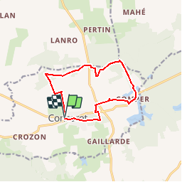
![](/images/other/stat-length.png)
![Trail Walking Concoret - Le château de Comper - Concoret - Photo](https://media.geolcdn.com/t/1900/400/ext.pjpeg?maxdim=2&url=https%3A%2F%2Fstatic1.geolcdn.com%2Fsiteimages%2Fupload%2Ffiles%2F1553511878bg_sport_marche.png)
Le château de Comper - Concoret
tracegps
User
![Length](/images/other/stat-length.png)
![Max alt](https://static1.geolcdn.com/siteimages/upload/files/1508320355ic_sort_altitude_max_24dp.png)
![Uphill gradient](https://static1.geolcdn.com/siteimages/upload/files/1508320355ic_sort_den_pos_24dp.png)
![Km-Effort](/images/other/stat-length.png)
![Min alt](https://static1.geolcdn.com/siteimages/upload/files/1508320355ic_sort_altitude_min_24dp.png)
![Downhill gradient](https://static1.geolcdn.com/siteimages/upload/files/1508320355ic_sort_den_neg_24dp.png)
![Boucle](https://static1.geolcdn.com/siteimages/upload/files/16400158638029165_repeat_loop_refresh_sync_direction_icon.png)
![Walking](https://static1.geolcdn.com/sitytour/trail-icons/101.png)
3h00
Difficulty : Medium
![Scan this QR Code to open this trail in the SityTrail application](https://capi.geolives.com/qq0zvz2zws4bq2lad0pu/sitytour/trails/112532/qr.png?size=200)
FREE GPS app for hiking
About
Trail Walking of 10.6 km to be discovered at Brittany, Morbihan, Concoret. This trail is proposed by tracegps.
Description
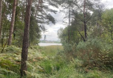
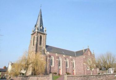
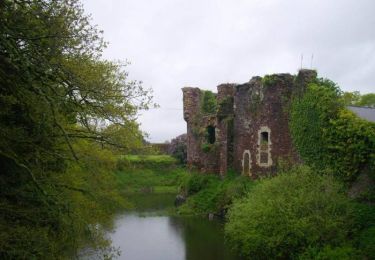
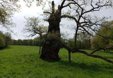
Point de départ : église de Concoret - Coordonnées GPS : 02°12’27’’O / 48°03’50’’N - Distance : 10 km - 3 h 00 A voir en chemin: 1. Concoret : commune du Patrimoine Rural de Bretagne. Vers 850, les seigneurs de Barenton et d’Isaugouët eurent un différent, et se réconcilièrent de façon miraculeuse : ils érigèrent alors la 1ère chapelle, pour Notre-Dame de la Concorde (épisode que l’on retrouve ans un vitrail du chœur). L’église actuelle est du 20ème siècle. Le clocher de cette église est tombé pendant la tempête de 1990 : il n’avait en fait jamais été fixé… 2. Château de Comper : château de la Dame du Lac dans la légende arthurienne. Murailles du XIIIème siècle, château en partie rénové au XIXème siècle. Occupé par le Centre de l’Imaginaire Arthurien, le château est visitable d’avril à octobre et abrite des expositions sur les légendes arthuriennes : le Graal, Merlin, la Dame du Lac, etc. 3. Les trois Roches de Trébran : trois gros blocs de poudingue reposent sur une ancienne voie romaine. Selon la croyance populaire, trois fées les transportaient vers le Mont Saint Michel, alors en construction. A l’annonce de la fin des travaux, les trois fées, soulagées, auraient laissé tomber les trois pierres là où elles se trouvent encore aujourd’hui. Office de tourisme du pays de Mauron en Brocéliande. Tel : 02 97 93 05 12 - Email : tourisme (at) valsansretour.com
Positioning
Comments
Trails nearby
![Trail Walking Paimpont - Paimpont entre deux étangs 9,7km - Photo](https://media.geolcdn.com/t/375/260/ext.jpg?maxdim=2&url=https%3A%2F%2Fstatic1.geolcdn.com%2Fsiteimages%2Fupload%2Ffiles%2F1553511878bg_sport_marche.png)
![Walking Walking](https://static1.geolcdn.com/sitytour/trail-icons/101.png)
Walking
![](/images/other/stat-length.png)
![](https://static1.geolcdn.com/siteimages/upload/files/16400158638029165_repeat_loop_refresh_sync_direction_icon.png)
![Trail Walking Paimpont - Paimpont 1 - Photo](https://media.geolcdn.com/t/375/260/c7f0a2a0-5b39-4bd2-80dc-5bfa400f8989.jpg&format=jpg&maxdim=2)
![Walking Walking](https://static1.geolcdn.com/sitytour/trail-icons/101.png)
![Trail Equestrian Paimpont - Les portes de la forêt de Paimpont côté Morbihan - Photo](https://media.geolcdn.com/t/375/260/ext.jpg?maxdim=2&url=https%3A%2F%2Fservices.sitytrail.com%2FGeolivesWS%2FDownloadMedia.ashx%3FTrailID%3D317276%26Media%3D16460_5.jpg)
![Equestrian Equestrian](https://static1.geolcdn.com/sitytour/trail-icons/300.png)
Equestrian
![](/images/other/stat-length.png)
![](https://static1.geolcdn.com/siteimages/upload/files/16400158638029165_repeat_loop_refresh_sync_direction_icon.png)
![Trail Equestrian Concoret - Le château de Comper - Concoret - Photo](https://media.geolcdn.com/t/375/260/ext.jpg?maxdim=2&url=https%3A%2F%2Fservices.sitytrail.com%2FGeolivesWS%2FDownloadMedia.ashx%3FTrailID%3D112818%26Media%3D12514_6.jpg)
![Equestrian Equestrian](https://static1.geolcdn.com/sitytour/trail-icons/300.png)
Equestrian
![](/images/other/stat-length.png)
![](https://static1.geolcdn.com/siteimages/upload/files/16400158638029165_repeat_loop_refresh_sync_direction_icon.png)
![Trail Mountain bike Concoret - Le château de Comper - Concoret - Photo](https://media.geolcdn.com/t/375/260/ext.jpg?maxdim=2&url=https%3A%2F%2Fservices.sitytrail.com%2FGeolivesWS%2FDownloadMedia.ashx%3FTrailID%3D112817%26Media%3D12514_6.jpg)
![Mountain bike Mountain bike](https://static1.geolcdn.com/sitytour/trail-icons/202.png)
Mountain bike
![](/images/other/stat-length.png)
![](https://static1.geolcdn.com/siteimages/upload/files/16400158638029165_repeat_loop_refresh_sync_direction_icon.png)
![Trail Walking Concoret - Le château de Comper - Concoret - Photo](https://media.geolcdn.com/t/375/260/ext.jpg?maxdim=2&url=https%3A%2F%2Fservices.sitytrail.com%2FGeolivesWS%2FDownloadMedia.ashx%3FTrailID%3D112816%26Media%3D12514_6.jpg)
![Walking Walking](https://static1.geolcdn.com/sitytour/trail-icons/101.png)
Walking
![](/images/other/stat-length.png)
![](https://static1.geolcdn.com/siteimages/upload/files/16400158638029165_repeat_loop_refresh_sync_direction_icon.png)
![Trail Walking Concoret - Vers le château de Comper - Concoret - Photo](https://media.geolcdn.com/t/375/260/ext.jpg?maxdim=2&url=https%3A%2F%2Fservices.sitytrail.com%2FGeolivesWS%2FDownloadMedia.ashx%3FTrailID%3D112683%26Media%3D11475_4.jpg)
![Walking Walking](https://static1.geolcdn.com/sitytour/trail-icons/101.png)
Walking
![](/images/other/stat-length.png)
![](https://static1.geolcdn.com/siteimages/upload/files/16400158638029165_repeat_loop_refresh_sync_direction_icon.png)
![Trail Walking Paimpont - PAIMPONT - Photo](https://media.geolcdn.com/t/375/260/caf6292e-29eb-440a-8b85-0ee040f025a9.jpg&format=jpg&maxdim=2)
![Walking Walking](https://static1.geolcdn.com/sitytour/trail-icons/101.png)
Walking
![](/images/other/stat-length.png)
![](https://static1.geolcdn.com/siteimages/upload/files/16400158638029165_repeat_loop_refresh_sync_direction_icon.png)
![Trail Walking Paimpont - Paimpont 2 - Photo](https://media.geolcdn.com/t/375/260/1cdfd923-ed8f-47fa-80af-7f6de225d6ed.jpg&format=jpg&maxdim=2)
![Walking Walking](https://static1.geolcdn.com/sitytour/trail-icons/101.png)
Walking
![](/images/other/stat-length.png)
![](https://static1.geolcdn.com/siteimages/upload/files/16400158638029165_repeat_loop_refresh_sync_direction_icon.png)