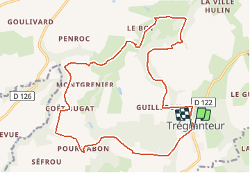
![](/images/other/stat-length.png)
![Trail Walking Guégon - Circuit de Trégranteur - Guégon - Photo](https://media.geolcdn.com/t/1900/400/ext.pjpeg?maxdim=2&url=https%3A%2F%2Fstatic1.geolcdn.com%2Fsiteimages%2Fupload%2Ffiles%2F1553511878bg_sport_marche.png)
Circuit de Trégranteur - Guégon
tracegps
User
![Length](/images/other/stat-length.png)
![Max alt](https://static1.geolcdn.com/siteimages/upload/files/1508320355ic_sort_altitude_max_24dp.png)
![Uphill gradient](https://static1.geolcdn.com/siteimages/upload/files/1508320355ic_sort_den_pos_24dp.png)
![Km-Effort](/images/other/stat-length.png)
![Min alt](https://static1.geolcdn.com/siteimages/upload/files/1508320355ic_sort_altitude_min_24dp.png)
![Downhill gradient](https://static1.geolcdn.com/siteimages/upload/files/1508320355ic_sort_den_neg_24dp.png)
![Boucle](https://static1.geolcdn.com/siteimages/upload/files/16400158638029165_repeat_loop_refresh_sync_direction_icon.png)
![Walking](https://static1.geolcdn.com/sitytour/trail-icons/101.png)
2h30
Difficulty : Medium
![Scan this QR Code to open this trail in the SityTrail application](https://capi.geolives.com/qq0zvz2zws4bq2lad0pu/sitytour/trails/112505/qr.png?size=200)
FREE GPS app for hiking
About
Trail Walking of 11.1 km to be discovered at Brittany, Morbihan, Guégon. This trail is proposed by tracegps.
Description
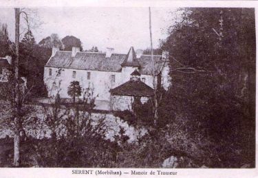
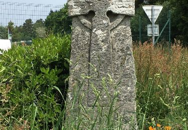
Point de départ : Église de Trégranteur (commune de Guégon). Coordonnées GPS : 02°32’41’’O / 47°54’04’’N - Distance : 11 km - 2 h 30 A voir en chemin: 1.Trégranteur : le manoir de Trégranteur est la propriété de la même famille depuis 1264, il a été construit par l’architecte Hippolyte de Brilhac. Ce manoir présente toutes les caractéristiques de la grande époque Louis XV. Le portail en ferronnerie date de 1750, il est attribué à Eustache Roussin, auteur de la chaire à prêcher de Josselin. En centre bourg, l’église Saint Mélec construite au 16ème siècle par les seigneurs de Trégarantec (ancien nom de Trégranteur) et Jean Thomé, recteur de Guégon, conserve une belle façade occidentale de style flamboyant. La Colonne de Justice (16ème-17ème siècle), très rare en Bretagne, située devant l’église est le symbole de l’autorité seigneuriale (armoiries sculptées). 2.Le moulin de Coët Digo : au détour du chemin, vous apercevrez le moulin de Coët Digo. Autrefois, la vallée du Sedon était bercée par le chant des moulins à eau. Malheureusement aujourd’hui, les moulins ne chantent plus… 3.La Croix de Mongrenier : cette croix aux dimensions imposantes fut érigée en 1827. 4.Bourg de Coët Bugat : l’église actuelle Notre Dame édifiée au 19ème siècle a remplacé l’édifice original. Elle a su conserver le style ogival du 13ème siècle. Elle abrite un véritable trésor, un tympan* classé en 1935. (* En architecture religieuse, surface plane située au-dessus du portail d’une église). Contact Office de tourisme de Josselin . Email : ot.josselin (at)wanadoo.fr
Positioning
Comments
Trails nearby
![Trail On foot Lizio - Sentier Botanique - Photo](https://media.geolcdn.com/t/375/260/e7996e9d-dd9b-4259-b3d2-d9a1e8e7f0ed.jpeg&format=jpg&maxdim=2)
![On foot On foot](https://static1.geolcdn.com/sitytour/trail-icons/100.png)
On foot
![](/images/other/stat-length.png)
![](https://static1.geolcdn.com/siteimages/upload/files/16400158638029165_repeat_loop_refresh_sync_direction_icon.png)
![Trail Walking Saint-Servant - GR_347_AE_05_St-Servant_Josselin_20190830 - Photo](https://media.geolcdn.com/t/375/260/688882ab-8277-4be6-b3d4-bcd62681374a.jpg&format=jpg&maxdim=2)
![Walking Walking](https://static1.geolcdn.com/sitytour/trail-icons/101.png)
Walking
![](/images/other/stat-length.png)
![](https://static1.geolcdn.com/siteimages/upload/files/16400158638029165_repeat_loop_refresh_sync_direction_icon.png)
![Trail On foot Lizio - Sentier des Landes - Photo](https://media.geolcdn.com/t/375/260/ext.jpg?maxdim=2&url=https%3A%2F%2Fstatic1.geolcdn.com%2Fsiteimages%2Fupload%2Ffiles%2F1545311037marcheuse_200dpi.jpg)
![On foot On foot](https://static1.geolcdn.com/sitytour/trail-icons/100.png)
On foot
![](/images/other/stat-length.png)
![](https://static1.geolcdn.com/siteimages/upload/files/16400158638029165_repeat_loop_refresh_sync_direction_icon.png)
![Trail Walking Cruguel - Guegon - Circuit des Picouras - Photo](https://media.geolcdn.com/t/375/260/ext.jpg?maxdim=2&url=https%3A%2F%2Fservices.sitytrail.com%2FGeolivesWS%2FDownloadMedia.ashx%3FTrailID%3D492161%26Media%3D20151110140037.jpg)
![Walking Walking](https://static1.geolcdn.com/sitytour/trail-icons/101.png)
Walking
![](/images/other/stat-length.png)
![](https://static1.geolcdn.com/siteimages/upload/files/16400158638029165_repeat_loop_refresh_sync_direction_icon.png)
![Trail Walking Lizio - lizio bis - Photo](https://media.geolcdn.com/t/375/260/926c4c0b-1b70-42f8-9e3d-9d115a92ee85.jpg&format=jpg&maxdim=2)
![Walking Walking](https://static1.geolcdn.com/sitytour/trail-icons/101.png)
![Trail Walking Lizio - Lizio morbihan - Photo](https://media.geolcdn.com/t/375/260/ext.jpg?maxdim=2&url=https%3A%2F%2Fstatic1.geolcdn.com%2Fsiteimages%2Fupload%2Ffiles%2F1553511878bg_sport_marche.png)
![Walking Walking](https://static1.geolcdn.com/sitytour/trail-icons/101.png)
Walking
![](/images/other/stat-length.png)
![](https://static1.geolcdn.com/siteimages/upload/files/16400158638029165_repeat_loop_refresh_sync_direction_icon.png)
![Trail Walking Guillac - lA croix des AnglaiS - Photo](https://media.geolcdn.com/t/375/260/ext.jpg?maxdim=2&url=https%3A%2F%2Fservices.sitytrail.com%2FGeolivesWS%2FDownloadMedia.ashx%3FTrailID%3D576920%26Media%3D20160530140730.jpg)
![Walking Walking](https://static1.geolcdn.com/sitytour/trail-icons/101.png)
Walking
![](/images/other/stat-length.png)
![](https://static1.geolcdn.com/siteimages/upload/files/16400158638029165_repeat_loop_refresh_sync_direction_icon.png)
![Trail Other activity Guillac - Canal Nantes-Brest (4) - Photo](https://media.geolcdn.com/t/375/260/ext.jpg?maxdim=2&url=https%3A%2F%2Fstatic1.geolcdn.com%2Fsiteimages%2Fupload%2Ffiles%2F1545311037marcheuse_200dpi.jpg)
![Other activity Other activity](https://static1.geolcdn.com/sitytour/trail-icons/900.png)
Other activity
![](/images/other/stat-length.png)
![](https://static1.geolcdn.com/siteimages/upload/files/16400158638029165_repeat_loop_refresh_sync_direction_icon.png)
![Trail Walking Lizio - Lizio sentier botanique - Photo](https://media.geolcdn.com/t/375/260/ext.jpg?maxdim=2&url=https%3A%2F%2Fstatic1.geolcdn.com%2Fsiteimages%2Fupload%2Ffiles%2F1553511878bg_sport_marche.png)
![Walking Walking](https://static1.geolcdn.com/sitytour/trail-icons/101.png)
Walking
![](/images/other/stat-length.png)
![](https://static1.geolcdn.com/siteimages/upload/files/16400158638029165_repeat_loop_refresh_sync_direction_icon.png)
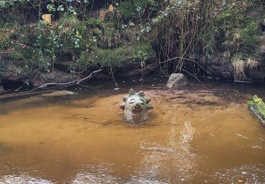
circuit à déconseillé en ce moment(20/11), de nombreux arbres, branches sont tombés suite à la tempête.Le déblaiement est en cours.