![](/images/other/stat-length.png)
![Trail Walking Porcaro - Boucle de la vallée de l'Oyon - Porcaro - Photo](https://media.geolcdn.com/t/1900/400/ext.pjpeg?maxdim=2&url=https%3A%2F%2Fstatic1.geolcdn.com%2Fsiteimages%2Fupload%2Ffiles%2F1553511878bg_sport_marche.png)
Boucle de la vallée de l'Oyon - Porcaro
tracegps
User
![Length](/images/other/stat-length.png)
![Max alt](https://static1.geolcdn.com/siteimages/upload/files/1508320355ic_sort_altitude_max_24dp.png)
![Uphill gradient](https://static1.geolcdn.com/siteimages/upload/files/1508320355ic_sort_den_pos_24dp.png)
![Km-Effort](/images/other/stat-length.png)
![Min alt](https://static1.geolcdn.com/siteimages/upload/files/1508320355ic_sort_altitude_min_24dp.png)
![Downhill gradient](https://static1.geolcdn.com/siteimages/upload/files/1508320355ic_sort_den_neg_24dp.png)
![Boucle](https://static1.geolcdn.com/siteimages/upload/files/16400158638029165_repeat_loop_refresh_sync_direction_icon.png)
![Walking](https://static1.geolcdn.com/sitytour/trail-icons/101.png)
4h45
Difficulty : Medium
![Scan this QR Code to open this trail in the SityTrail application](https://capi.geolives.com/qq0zvz2zws4bq2lad0pu/sitytour/trails/112502/qr.png?size=200)
FREE GPS app for hiking
About
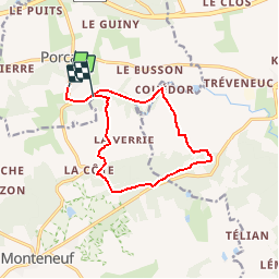
Trail Walking of 11 km to be discovered at Brittany, Morbihan, Porcaro. This trail is proposed by tracegps.
Description
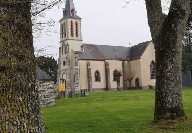
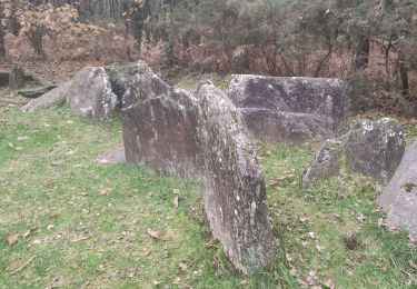
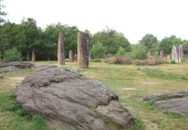
Point de départ : maison des motards, bourg de Porcaro (coordonnées GPS : 02°11’57’’O / 47°54’33’’N) Distance : 16 km - 4 h 45 A voir en chemin : 1. L’étang de la Priaudais : la tranquillité du lieu vous invite à en faire le tour et ainsi vous plonger dans la vallée de l’Oyon. 2. Le Prieuré Saint-Étienne : cet ancien grand village est l’un des principaux centres historiques du Pays de Guer. La chapelle, la plus ancienne du Morbihan (832) est classée Monument Historique. Durant la période gallo-romaine, St Etienne fut un centre administratif, militaire et résidentiel d’importance. 3. La Pierre Tremblante : non reconnu officiellement comme monument mégalithique, ce site n’en demeure pas moins mystérieux avec la fontaine limpide, sa table à sacrifice et surtout un énorme bloc en pierre. 4. La Tête de Gore : émergence rocheuse remarquable par son abrupt belvédère qui domine le cours de l’Oyon. Contact Office de tourisme du Pays de Guer-Coëtquidan - 02 97 22 04 78 – email :contact (at)guer-coetquidan-tourisme.com
Positioning
Comments
Trails nearby
![Trail Walking Monteneuf - PR_56_Monteneuf_AA_01_Circuit1b_Boucle-Des-Megalithes_20220508 - Photo](https://media.geolcdn.com/t/375/260/80cdb1b4-53c8-4d6d-96c2-422c67c4e04c.jpg&format=jpg&maxdim=2)
![Walking Walking](https://static1.geolcdn.com/sitytour/trail-icons/101.png)
Walking
![](/images/other/stat-length.png)
![](https://static1.geolcdn.com/siteimages/upload/files/16400158638029165_repeat_loop_refresh_sync_direction_icon.png)
![Trail On foot Monteneuf - La Boucle du Chaperon-Rouge - Photo](https://media.geolcdn.com/t/375/260/3270e6a7-4aba-47d6-9bf3-560c5ab3cd4e.jpeg&format=jpg&maxdim=2)
![On foot On foot](https://static1.geolcdn.com/sitytour/trail-icons/100.png)
On foot
![](/images/other/stat-length.png)
![](https://static1.geolcdn.com/siteimages/upload/files/16400158638029165_repeat_loop_refresh_sync_direction_icon.png)
![Trail Walking Monteneuf - alignement Monteneuf - Photo](https://media.geolcdn.com/t/375/260/fc983100-b7ff-4e05-891c-98ae4da66695.jpg&format=jpg&maxdim=2)
![Walking Walking](https://static1.geolcdn.com/sitytour/trail-icons/101.png)
Walking
![](/images/other/stat-length.png)
![](https://static1.geolcdn.com/siteimages/upload/files/16400158638029165_repeat_loop_refresh_sync_direction_icon.png)
![Trail Walking Porcaro - 214- rando de la vallée de l'Oyon par Porcaro - Photo](https://media.geolcdn.com/t/375/260/e0e2e920-cb3d-45e1-aea1-7273d613aaf1.jpg&format=jpg&maxdim=2)
![Walking Walking](https://static1.geolcdn.com/sitytour/trail-icons/101.png)
Walking
![](/images/other/stat-length.png)
![](https://static1.geolcdn.com/siteimages/upload/files/16400158638029165_repeat_loop_refresh_sync_direction_icon.png)
![Trail Walking Monteneuf - monteneuf randoplo - Photo](https://media.geolcdn.com/t/375/260/d6e67f36-f1aa-4b96-a17a-fd74c27067f4.jpg&format=jpg&maxdim=2)
![Walking Walking](https://static1.geolcdn.com/sitytour/trail-icons/101.png)
Walking
![](/images/other/stat-length.png)
![](https://static1.geolcdn.com/siteimages/upload/files/16400158638029165_repeat_loop_refresh_sync_direction_icon.png)
![Trail On foot Monteneuf - Boucle de l'étang de Quéhéon - Photo](https://media.geolcdn.com/t/375/260/62377f27-ad71-4b92-9f68-464cfc37b4f8.jpeg&format=jpg&maxdim=2)
![On foot On foot](https://static1.geolcdn.com/sitytour/trail-icons/100.png)
On foot
![](/images/other/stat-length.png)
![](https://static1.geolcdn.com/siteimages/upload/files/16400158638029165_repeat_loop_refresh_sync_direction_icon.png)
![Trail On foot Monteneuf - Boucle de la pièce couverte - Photo](https://media.geolcdn.com/t/375/260/62377f27-ad71-4b92-9f68-464cfc37b4f8.jpeg&format=jpg&maxdim=2)
![On foot On foot](https://static1.geolcdn.com/sitytour/trail-icons/100.png)
On foot
![](/images/other/stat-length.png)
![](https://static1.geolcdn.com/siteimages/upload/files/16400158638029165_repeat_loop_refresh_sync_direction_icon.png)
![Trail On foot Monteneuf - Boucle de la loge Morinais - Photo](https://media.geolcdn.com/t/375/260/62377f27-ad71-4b92-9f68-464cfc37b4f8.jpeg&format=jpg&maxdim=2)
![On foot On foot](https://static1.geolcdn.com/sitytour/trail-icons/100.png)
On foot
![](/images/other/stat-length.png)
![](https://static1.geolcdn.com/siteimages/upload/files/16400158638029165_repeat_loop_refresh_sync_direction_icon.png)
![Trail Walking Monteneuf - Monteneuf - Photo](https://media.geolcdn.com/t/375/260/235f03b1-4bbf-42d0-bd3c-2ec9e3c0cb77.jpg&format=jpg&maxdim=2)
![Walking Walking](https://static1.geolcdn.com/sitytour/trail-icons/101.png)