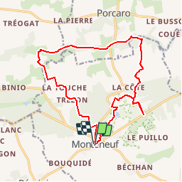
![](/images/other/stat-length.png)
![Trail Walking Monteneuf - Circuit du chaperon rouge - Monteneuf - Photo](https://media.geolcdn.com/t/1900/400/ext.pjpeg?maxdim=2&url=https%3A%2F%2Fstatic1.geolcdn.com%2Fsiteimages%2Fupload%2Ffiles%2F1553511878bg_sport_marche.png)
Circuit du chaperon rouge - Monteneuf
tracegps
User
![Length](/images/other/stat-length.png)
![Max alt](https://static1.geolcdn.com/siteimages/upload/files/1508320355ic_sort_altitude_max_24dp.png)
![Uphill gradient](https://static1.geolcdn.com/siteimages/upload/files/1508320355ic_sort_den_pos_24dp.png)
![Km-Effort](/images/other/stat-length.png)
![Min alt](https://static1.geolcdn.com/siteimages/upload/files/1508320355ic_sort_altitude_min_24dp.png)
![Downhill gradient](https://static1.geolcdn.com/siteimages/upload/files/1508320355ic_sort_den_neg_24dp.png)
![Boucle](https://static1.geolcdn.com/siteimages/upload/files/16400158638029165_repeat_loop_refresh_sync_direction_icon.png)
![Walking](https://static1.geolcdn.com/sitytour/trail-icons/101.png)
4h00
Difficulty : Medium
![Scan this QR Code to open this trail in the SityTrail application](https://capi.geolives.com/qq0zvz2zws4bq2lad0pu/sitytour/trails/112499/qr.png?size=200)
FREE GPS app for hiking
About
Trail Walking of 16.8 km to be discovered at Brittany, Morbihan, Monteneuf. This trail is proposed by tracegps.
Description
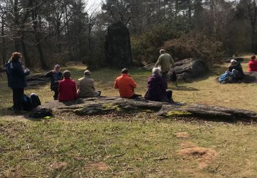
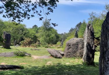
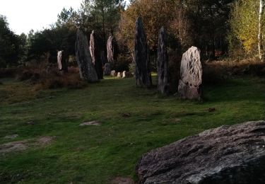
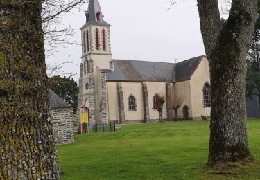
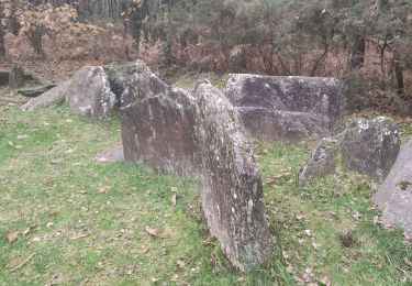
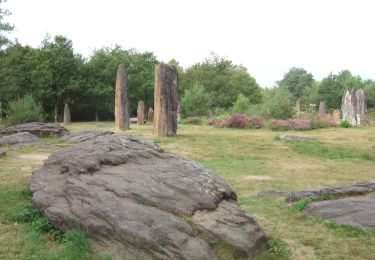
A voir en chemin: 1. Etang du Chaperon Rouge : dans les rochers affleurant, sur le côté de la digue, vous découvrirez le refuge du « bonnet rouge », un révolutionnaire sous Louis XIV se cachant, avait taillé la pierre à cet endroit pour en faire un siège. 2. Etang de Quéhéon : si vous avez du temps, contournez l’étang par le nord, engagez-vous dans la tourbière sur la droite à la sortie. Vous aurez peut-être la chance d’y voir des gentianes, de la drosera, fleurs protégées et au moins trois variétés de bruyère. 3. La Loge Morinais : elle est certainement la plus charmante des allées couvertes en raison de sa situation au milieu de la lande. Entre landes sèches et landes humides on rencontre une grande diversité faune / flore. 4. La Vallée de l’Oyon : vous pourrez découvrir le Tombeau des Rochettes (tertre tumulaire de l’âge de bronze), la tête de Gore (belvédère dominant le cours de l’Oyon) et l’étang de la Priaudais. Contact Office de tourisme du Pays de Guer-Coëtquidan - 02 97 22 04 78 Contact (at)guer-coetquidan-tourisme.com
Positioning
Comments
Trails nearby
![Trail Walking Monteneuf - PR_56_Monteneuf_AA_01_Circuit1b_Boucle-Des-Megalithes_20220508 - Photo](https://media.geolcdn.com/t/375/260/80cdb1b4-53c8-4d6d-96c2-422c67c4e04c.jpg&format=jpg&maxdim=2)
![Walking Walking](https://static1.geolcdn.com/sitytour/trail-icons/101.png)
Walking
![](/images/other/stat-length.png)
![](https://static1.geolcdn.com/siteimages/upload/files/16400158638029165_repeat_loop_refresh_sync_direction_icon.png)
![Trail On foot Monteneuf - La Boucle du Chaperon-Rouge - Photo](https://media.geolcdn.com/t/375/260/3270e6a7-4aba-47d6-9bf3-560c5ab3cd4e.jpeg&format=jpg&maxdim=2)
![On foot On foot](https://static1.geolcdn.com/sitytour/trail-icons/100.png)
On foot
![](/images/other/stat-length.png)
![](https://static1.geolcdn.com/siteimages/upload/files/16400158638029165_repeat_loop_refresh_sync_direction_icon.png)
![Trail Walking Monteneuf - alignement Monteneuf - Photo](https://media.geolcdn.com/t/375/260/fc983100-b7ff-4e05-891c-98ae4da66695.jpg&format=jpg&maxdim=2)
![Walking Walking](https://static1.geolcdn.com/sitytour/trail-icons/101.png)
Walking
![](/images/other/stat-length.png)
![](https://static1.geolcdn.com/siteimages/upload/files/16400158638029165_repeat_loop_refresh_sync_direction_icon.png)
![Trail Walking Porcaro - 214- rando de la vallée de l'Oyon par Porcaro - Photo](https://media.geolcdn.com/t/375/260/e0e2e920-cb3d-45e1-aea1-7273d613aaf1.jpg&format=jpg&maxdim=2)
![Walking Walking](https://static1.geolcdn.com/sitytour/trail-icons/101.png)
Walking
![](/images/other/stat-length.png)
![](https://static1.geolcdn.com/siteimages/upload/files/16400158638029165_repeat_loop_refresh_sync_direction_icon.png)
![Trail Walking Monteneuf - monteneuf randoplo - Photo](https://media.geolcdn.com/t/375/260/d6e67f36-f1aa-4b96-a17a-fd74c27067f4.jpg&format=jpg&maxdim=2)
![Walking Walking](https://static1.geolcdn.com/sitytour/trail-icons/101.png)
Walking
![](/images/other/stat-length.png)
![](https://static1.geolcdn.com/siteimages/upload/files/16400158638029165_repeat_loop_refresh_sync_direction_icon.png)
![Trail On foot Monteneuf - Boucle de l'étang de Quéhéon - Photo](https://media.geolcdn.com/t/375/260/62377f27-ad71-4b92-9f68-464cfc37b4f8.jpeg&format=jpg&maxdim=2)
![On foot On foot](https://static1.geolcdn.com/sitytour/trail-icons/100.png)
On foot
![](/images/other/stat-length.png)
![](https://static1.geolcdn.com/siteimages/upload/files/16400158638029165_repeat_loop_refresh_sync_direction_icon.png)
![Trail On foot Monteneuf - Boucle de la pièce couverte - Photo](https://media.geolcdn.com/t/375/260/62377f27-ad71-4b92-9f68-464cfc37b4f8.jpeg&format=jpg&maxdim=2)
![On foot On foot](https://static1.geolcdn.com/sitytour/trail-icons/100.png)
On foot
![](/images/other/stat-length.png)
![](https://static1.geolcdn.com/siteimages/upload/files/16400158638029165_repeat_loop_refresh_sync_direction_icon.png)
![Trail On foot Monteneuf - Boucle de la loge Morinais - Photo](https://media.geolcdn.com/t/375/260/62377f27-ad71-4b92-9f68-464cfc37b4f8.jpeg&format=jpg&maxdim=2)
![On foot On foot](https://static1.geolcdn.com/sitytour/trail-icons/100.png)
On foot
![](/images/other/stat-length.png)
![](https://static1.geolcdn.com/siteimages/upload/files/16400158638029165_repeat_loop_refresh_sync_direction_icon.png)
![Trail Walking Monteneuf - Monteneuf - Photo](https://media.geolcdn.com/t/375/260/235f03b1-4bbf-42d0-bd3c-2ec9e3c0cb77.jpg&format=jpg&maxdim=2)
![Walking Walking](https://static1.geolcdn.com/sitytour/trail-icons/101.png)