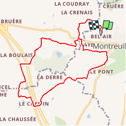
![](/images/other/stat-length.png)
![Trail Equestrian Montreuil-le-Gast - Circuit de Montboucher - Montreuil-le-Gast - Photo](https://media.geolcdn.com/t/1900/400/ext.pjpeg?maxdim=2&url=https%3A%2F%2Fservices.sitytrail.com%2FGeolivesWS%2FDownloadMedia.ashx%3FTrailID%3D112326%26Media%3D10338_3.jpg)
Circuit de Montboucher - Montreuil-le-Gast
tracegps
User
![Length](/images/other/stat-length.png)
![Max alt](https://static1.geolcdn.com/siteimages/upload/files/1508320355ic_sort_altitude_max_24dp.png)
![Uphill gradient](https://static1.geolcdn.com/siteimages/upload/files/1508320355ic_sort_den_pos_24dp.png)
![Km-Effort](/images/other/stat-length.png)
![Min alt](https://static1.geolcdn.com/siteimages/upload/files/1508320355ic_sort_altitude_min_24dp.png)
![Downhill gradient](https://static1.geolcdn.com/siteimages/upload/files/1508320355ic_sort_den_neg_24dp.png)
![Boucle](https://static1.geolcdn.com/siteimages/upload/files/16400158638029165_repeat_loop_refresh_sync_direction_icon.png)
![Equestrian](https://static1.geolcdn.com/sitytour/trail-icons/300.png)
1h30
Difficulty : Easy
![Scan this QR Code to open this trail in the SityTrail application](https://capi.geolives.com/qq0zvz2zws4bq2lad0pu/sitytour/trails/112326/qr.png?size=200)
FREE GPS app for hiking
About
Trail Equestrian of 10.5 km to be discovered at Brittany, Ille-et-Vilaine, Montreuil-le-Gast. This trail is proposed by tracegps.
Description
Circuit proposé par la Communauté de Communes du Val d’Ille. Départ de la ferme équestre de Bel Air. Montboucher fut le berceau d’une grande famille « de Montboucher ». Déjà cité en 1040, ils étaient parmi les croisés de Saint-Louis. La «Motte à Madame» enceinte défensive terroyée, encore présente à l’ouest du bois (privé), date sans doute du XIe siècle. Retrouvez la fiche du circuit sur le site de la Communauté de Communes du Val d’Ille.
Positioning
Comments
Trails nearby
![Trail On foot Melesse - Sentier des Melessiens - Photo](https://media.geolcdn.com/t/375/260/0f30e474-f118-48a0-a59b-66ca1ed3bb91.jpeg&format=jpg&maxdim=2)
![On foot On foot](https://static1.geolcdn.com/sitytour/trail-icons/100.png)
On foot
![](/images/other/stat-length.png)
![](https://static1.geolcdn.com/siteimages/upload/files/16400158638029165_repeat_loop_refresh_sync_direction_icon.png)
![Trail On foot Saint-Médard-sur-Ille - Le Bois de Cranne - Photo](https://media.geolcdn.com/t/375/260/d1c048d2-ce9b-4bbc-8166-22a8dfba9cca.jpeg&format=jpg&maxdim=2)
![On foot On foot](https://static1.geolcdn.com/sitytour/trail-icons/100.png)
On foot
![](/images/other/stat-length.png)
![](https://static1.geolcdn.com/siteimages/upload/files/16400158638029165_repeat_loop_refresh_sync_direction_icon.png)
![Trail On foot Montreuil-le-Gast - La Fosse du Loup - Photo](https://media.geolcdn.com/t/375/260/23710b22-992a-44ea-99ef-dabc47ec71b0.jpeg&format=jpg&maxdim=2)
![On foot On foot](https://static1.geolcdn.com/sitytour/trail-icons/100.png)
On foot
![](/images/other/stat-length.png)
![](https://static1.geolcdn.com/siteimages/upload/files/16400158638029165_repeat_loop_refresh_sync_direction_icon.png)
![Trail On foot La Mézière - Circuit de La Rivière - Photo](https://media.geolcdn.com/t/375/260/effb608e-9523-4c80-8eff-d9597a799e45.jpeg&format=jpg&maxdim=2)
![On foot On foot](https://static1.geolcdn.com/sitytour/trail-icons/100.png)
On foot
![](/images/other/stat-length.png)
![](https://static1.geolcdn.com/siteimages/upload/files/16400158638029165_repeat_loop_refresh_sync_direction_icon.png)
![Trail On foot Gévezé - Circuit du Cheval Blanc - Photo](https://media.geolcdn.com/t/375/260/6a65d215-7eed-44b7-9d26-d5e20ab6f1d2.jpeg&format=jpg&maxdim=2)
![On foot On foot](https://static1.geolcdn.com/sitytour/trail-icons/100.png)
On foot
![](/images/other/stat-length.png)
![](https://static1.geolcdn.com/siteimages/upload/files/16400158638029165_repeat_loop_refresh_sync_direction_icon.png)
![Trail On foot Gévezé - Sentier de la Chaussée - Photo](https://media.geolcdn.com/t/375/260/b68bfa03-18ec-4b2e-a7fc-64dc0a472980.jpeg&format=jpg&maxdim=2)
![On foot On foot](https://static1.geolcdn.com/sitytour/trail-icons/100.png)
On foot
![](/images/other/stat-length.png)
![](https://static1.geolcdn.com/siteimages/upload/files/16400158638029165_repeat_loop_refresh_sync_direction_icon.png)
![Trail On foot La Mézière - Sentier de Montgerval - Photo](https://media.geolcdn.com/t/375/260/f85f597a-f5d9-4626-9ff3-a4f1fc6b4cfc.jpeg&format=jpg&maxdim=2)
![On foot On foot](https://static1.geolcdn.com/sitytour/trail-icons/100.png)
On foot
![](/images/other/stat-length.png)
![](https://static1.geolcdn.com/siteimages/upload/files/16400158638029165_repeat_loop_refresh_sync_direction_icon.png)
![Trail On foot Gévezé - Circuit du Moulin de la Moltais - Photo](https://media.geolcdn.com/t/375/260/0b61b143-c705-414e-8194-5fcc4095b5f1.jpeg&format=jpg&maxdim=2)
![On foot On foot](https://static1.geolcdn.com/sitytour/trail-icons/100.png)
On foot
![](/images/other/stat-length.png)
![](https://static1.geolcdn.com/siteimages/upload/files/16400158638029165_repeat_loop_refresh_sync_direction_icon.png)
![Trail On foot Gévezé - Circuit de la Motte Marcillé - Photo](https://media.geolcdn.com/t/375/260/92a5fd14-c2a6-4b26-bc47-2f8fa78eecb4.jpeg&format=jpg&maxdim=2)
![On foot On foot](https://static1.geolcdn.com/sitytour/trail-icons/100.png)
On foot
![](/images/other/stat-length.png)
![](https://static1.geolcdn.com/siteimages/upload/files/16400158638029165_repeat_loop_refresh_sync_direction_icon.png)