![](/images/other/stat-length.png)
![Trail Walking Pas-en-Artois - Sentier des Bois - Pas-en-Artois - Photo](https://media.geolcdn.com/t/1900/400/ext.pjpeg?maxdim=2&url=https%3A%2F%2Fservices.sitytrail.com%2FGeolivesWS%2FDownloadMedia.ashx%3FTrailID%3D112319%26Media%3D10322_3.jpg)
Sentier des Bois - Pas-en-Artois
tracegps
User
![Length](/images/other/stat-length.png)
Length
8.7 km
![Max alt](https://static1.geolcdn.com/siteimages/upload/files/1508320355ic_sort_altitude_max_24dp.png)
Max alt
147 m
![Uphill gradient](https://static1.geolcdn.com/siteimages/upload/files/1508320355ic_sort_den_pos_24dp.png)
Uphill gradient
153 m
![Km-Effort](/images/other/stat-length.png)
Km-Effort
10.7 km
![Min alt](https://static1.geolcdn.com/siteimages/upload/files/1508320355ic_sort_altitude_min_24dp.png)
Min alt
86 m
![Downhill gradient](https://static1.geolcdn.com/siteimages/upload/files/1508320355ic_sort_den_neg_24dp.png)
Downhill gradient
153 m
![Boucle](https://static1.geolcdn.com/siteimages/upload/files/16400158638029165_repeat_loop_refresh_sync_direction_icon.png)
Boucle
Yes
Creation date :
2014-12-10 00:00:00.0
Updated on :
2014-12-10 00:00:00.0
![Walking](https://static1.geolcdn.com/sitytour/trail-icons/101.png)
2h10
Difficulty : Medium
![Scan this QR Code to open this trail in the SityTrail application](https://capi.geolives.com/qq0zvz2zws4bq2lad0pu/sitytour/trails/112319/qr.png?size=200)
FREE GPS app for hiking
About
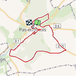
Trail Walking of 8.7 km to be discovered at Hauts-de-France, Pas-de-Calais, Pas-en-Artois. This trail is proposed by tracegps.
Description
Circuit proposé par la Communauté de Communes des 2 Sources. Départ de la Mairie de Pas-en-Artois. Retrouvez le goût de la nature, le temps d’une balade entre bois, campagne et cœur de commune. Retrouvez le circuit et son descriptif sur le site de la Communauté de Communes des 2 Sources.
Positioning
Country:
France
Region :
Hauts-de-France
Department/Province :
Pas-de-Calais
Municipality :
Pas-en-Artois
Location:
Unknown
Start:(Dec)
Start:(UTM)
463644 ; 5555907 (31U) N.
Comments
Trails nearby
![Trail On foot Authie - Autour du Prieuré d'Authie - Photo](https://media.geolcdn.com/t/375/260/615b8716-cb3c-49d0-a4d5-2a1445f622bb.jpeg&format=jpg&maxdim=2)
![On foot On foot](https://static1.geolcdn.com/sitytour/trail-icons/100.png)
Autour du Prieuré d'Authie
On foot
Easy
Authie,
Hauts-de-France,
Somme,
France
![](/images/other/stat-length.png)
10 km | 11.8 km-effort
2h 41min
![](https://static1.geolcdn.com/siteimages/upload/files/16400158638029165_repeat_loop_refresh_sync_direction_icon.png)
Yes
![Trail Walking Thièvres - Sentier de la montagne - Thièvres - Photo](https://media.geolcdn.com/t/375/260/ext.jpg?maxdim=2&url=https%3A%2F%2Fservices.sitytrail.com%2FGeolivesWS%2FDownloadMedia.ashx%3FTrailID%3D112370%26Media%3D10471_3.jpg)
![Walking Walking](https://static1.geolcdn.com/sitytour/trail-icons/101.png)
Sentier de la montagne - Thièvres
Walking
Medium
Thièvres,
Hauts-de-France,
Somme,
France
![](/images/other/stat-length.png)
8.7 km | 10.1 km-effort
2h 10min
![](https://static1.geolcdn.com/siteimages/upload/files/16400158638029165_repeat_loop_refresh_sync_direction_icon.png)
Yes
![Trail Walking Thièvres - Sentier du Fay - Grand-Rullecourt - Photo](https://media.geolcdn.com/t/375/260/ext.jpg?maxdim=2&url=https%3A%2F%2Fservices.sitytrail.com%2FGeolivesWS%2FDownloadMedia.ashx%3FTrailID%3D112321%26Media%3D10326_3.jpg)
![Walking Walking](https://static1.geolcdn.com/sitytour/trail-icons/101.png)
Sentier du Fay - Grand-Rullecourt
Walking
Very difficult
Thièvres,
Hauts-de-France,
Somme,
France
![](/images/other/stat-length.png)
8.7 km | 10.1 km-effort
4h 25min
![](https://static1.geolcdn.com/siteimages/upload/files/16400158638029165_repeat_loop_refresh_sync_direction_icon.png)
Yes
![Trail Walking Thièvres - THIEVRES - Circuit de l'arbre de Cocagne - Photo](https://media.geolcdn.com/t/375/260/8864e809-4f19-4cce-8053-ed264327b169.jpg&format=jpg&maxdim=2)
![Walking Walking](https://static1.geolcdn.com/sitytour/trail-icons/101.png)
THIEVRES - Circuit de l'arbre de Cocagne
Walking
Medium
Thièvres,
Hauts-de-France,
Pas-de-Calais,
France
![](/images/other/stat-length.png)
8.8 km | 10.6 km-effort
2h 24min
![](https://static1.geolcdn.com/siteimages/upload/files/16400158638029165_repeat_loop_refresh_sync_direction_icon.png)
Yes
![Trail Walking Authie - Autour du Prieuré d'Authie - Photo](https://media.geolcdn.com/t/375/260/ext.jpg?maxdim=2&url=https%3A%2F%2Fservices.sitytrail.com%2FGeolivesWS%2FDownloadMedia.ashx%3FTrailID%3D108846%26Media%3D2390_1.jpg)
![Walking Walking](https://static1.geolcdn.com/sitytour/trail-icons/101.png)
Autour du Prieuré d'Authie
Walking
Medium
(1)
Authie,
Hauts-de-France,
Somme,
France
![](/images/other/stat-length.png)
10.1 km | 12 km-effort
3h 19min
![](https://static1.geolcdn.com/siteimages/upload/files/16400158638029165_repeat_loop_refresh_sync_direction_icon.png)
Yes
![Trail Walking Souastre - Souastre - Couin - Coigneux - Photo](https://media.geolcdn.com/t/375/260/ext.jpg?maxdim=2&url=https%3A%2F%2Fstatic1.geolcdn.com%2Fsiteimages%2Fupload%2Ffiles%2F1553511878bg_sport_marche.png)
![Walking Walking](https://static1.geolcdn.com/sitytour/trail-icons/101.png)
Souastre - Couin - Coigneux
Walking
Medium
Souastre,
Hauts-de-France,
Pas-de-Calais,
France
![](/images/other/stat-length.png)
8.8 km | 9.9 km-effort
2h 0min
![](https://static1.geolcdn.com/siteimages/upload/files/16400158638029165_repeat_loop_refresh_sync_direction_icon.png)
Yes
![Trail Walking Thièvres - kjv - Photo](https://media.geolcdn.com/t/375/260/ext.jpg?maxdim=2&url=https%3A%2F%2Fstatic1.geolcdn.com%2Fsiteimages%2Fupload%2Ffiles%2F1553511878bg_sport_marche.png)
![Walking Walking](https://static1.geolcdn.com/sitytour/trail-icons/101.png)